Ai-Petri
Ai-Petri (Crimean Tatar: Ay Petri, Ukrainian: Ай-Петрі, romanized: Ay-Petri) is a peak in the Crimean Mountains. For administrative purposes it is in the Yalta municipality of Crimea. The name is of Greek origin, and translates as "St. Peter" (Greek: Άγιος Πέτρος, romanized: Ágios Pétros).
| Ai-Petri | |
|---|---|
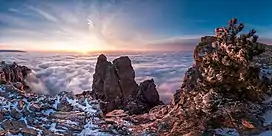 A panorama of the winter on Ai-Petri | |
| Highest point | |
| Elevation | 1,234 m (4,049 ft)[1] |
| Listing | Mountains of Ukraine |
| Coordinates | 44°27′04″N 34°3′10″E |
| Geography | |
.jpg.webp) Ai-Petri | |
| Parent range | Crimean Mountains |
Overview
Ai-Petri is one of the windiest places in Crimea. The wind blows for 125 days a year, reaching a speed of 50 m/s (110 mph).[2]
The peak is located above the city of Alupka and the town of Koreiz.
There is a cable car that takes passengers from a station near Alupka to the main area in Ai-Petri.
The Ai-Petri massif makes up one side of the Grand Canyon of Crimea, with the other side being the Boyka massif.
Climate
| Climate data for Ai-Petri (1991–2020, temperatures and humidity 1981-2010) | |||||||||||||
|---|---|---|---|---|---|---|---|---|---|---|---|---|---|
| Month | Jan | Feb | Mar | Apr | May | Jun | Jul | Aug | Sep | Oct | Nov | Dec | Year |
| Mean daily maximum °C (°F) | −0.3 (31.5) |
−0.3 (31.5) |
2.5 (36.5) |
8.2 (46.8) |
12.9 (55.2) |
16.9 (62.4) |
19.8 (67.6) |
19.6 (67.3) |
14.9 (58.8) |
10.6 (51.1) |
5.5 (41.9) |
1.3 (34.3) |
9.3 (48.7) |
| Daily mean °C (°F) | −3.1 (26.4) |
−3.4 (25.9) |
−0.7 (30.7) |
4.6 (40.3) |
9.6 (49.3) |
13.3 (55.9) |
16.0 (60.8) |
15.8 (60.4) |
11.2 (52.2) |
7.0 (44.6) |
2.4 (36.3) |
−1.4 (29.5) |
5.9 (42.6) |
| Mean daily minimum °C (°F) | −5.9 (21.4) |
−6.5 (20.3) |
−3.9 (25.0) |
1.4 (34.5) |
6.2 (43.2) |
9.8 (49.6) |
12.4 (54.3) |
12.2 (54.0) |
7.8 (46.0) |
3.6 (38.5) |
−0.8 (30.6) |
−4.3 (24.3) |
2.7 (36.9) |
| Average precipitation mm (inches) | 125 (4.9) |
118 (4.6) |
84 (3.3) |
58 (2.3) |
57 (2.2) |
69 (2.7) |
47 (1.9) |
57 (2.2) |
73 (2.9) |
84 (3.3) |
104 (4.1) |
139 (5.5) |
1,015 (39.9) |
| Average precipitation days (≥ 1.0 mm) | 14 | 11 | 12 | 8 | 7 | 7 | 5 | 6 | 7 | 8 | 9 | 13 | 107 |
| Average relative humidity (%) | 81.7 | 79.4 | 75.8 | 68.8 | 66.5 | 68.8 | 66.1 | 66.2 | 70.6 | 71.7 | 74.1 | 81.4 | 72.6 |
| Mean monthly sunshine hours | 85 | 103 | 144 | 188 | 264 | 286 | 320 | 290 | 219 | 170 | 115 | 75 | 2,259 |
| Source: NCEI[3][4] | |||||||||||||
Images
.jpg.webp) A panoramic view from Ai-Petri.
A panoramic view from Ai-Petri. View of Ai-Petri from Vorontsov's Palace in Alupka.
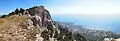 View on Ai-Petri
_da%C4%9Flar%C4%B1.jpg.webp) View of Ai-Petri from Vorontsov's Palace in Alupka.
View of Ai-Petri from Vorontsov's Palace in Alupka.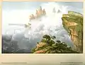 Ai-Petri in the 1850s, by Carlo Bossoli
References
Wikimedia Commons has media related to Aj-Petri.
- "Topographic map of Ai-Petri". opentopomap.org. Retrieved 2023-05-02.
- "Ai-Petri Mountain" (in Russian). Archived from the original on 2010-04-08.
- "World Meteorological Organization Climate Normals for 1991–2020: Ai-Petri" (CSV). National Canters for Environmental Information. Retrieved 30 March 2024.
- "World Meteorological Organization Climate Normals for 1981–2010". National Canters for Environmental Information. Archived from the original on 17 July 2021. Retrieved 18 July 2021.
| Mountains |
|  |
|---|---|---|
| Passes |
| |
| Landforms |
| |
| Palaces |
| |
| Fortresses |
| |
| Churches |
| |
| Ancient cities |
| |
| Others |
| |
This article is issued from Wikipedia. The text is licensed under Creative Commons - Attribution - Sharealike. Additional terms may apply for the media files.