Ankara Province
Ankara Province (Turkish: Ankara ili, pronounced [ˈaŋkaɾa iˈli]) is a province and metropolitan municipality of Turkey with the capital city Ankara. Its area is 25,632 km2,[2] and its population is 5,782,285 (2022).[1]
Ankara Province
Ankara ili | |
|---|---|
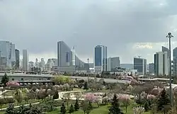
Ankara skyline | |
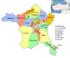
 Location of the province within Turkey | |
| Country | Turkey |
| Seat | Ankara |
| Government | |
| • Mayor | Mansur Yavaş (CHP) |
| • Vali | Vasip Şahin |
| Area | 25,632 km2 (9,897 sq mi) |
| Population (2022)[1] | 5,782,285 |
| • Density | 230/km2 (580/sq mi) |
| Time zone | UTC+3 (TRT) |
| Area code | 0312 |
| Website | www www |

Demographics
| Year | Pop. | ±% p.a. |
|---|---|---|
| 1927 | 404,720 | — |
| 1940 | 602,965 | +3.11% |
| 1950 | 819,693 | +3.12% |
| 1960 | 1,321,380 | +4.89% |
| 1970 | 2,041,658 | +4.45% |
| 1980 | 2,854,689 | +3.41% |
| 1990 | 3,236,626 | +1.26% |
| 2000 | 4,007,860 | +2.16% |
| 2010 | 4,771,716 | +1.76% |
| 2020 | 5,663,322 | +1.73% |
| 2022 | 5,782,285 | +1.04% |
| source:[3][4][5][1] | ||
History
The site of the modern city has been home to settlements by many historic Anatolian civilizations in antiquity and classical times, including Phrygians, Lydians, Persians and Alexander the Great, Romans, and Galatians. The city of Ankara became a fortified stronghold of the Byzantines; it fell to the Seljuk Turks and later the Ottoman Empire. It was finally chosen by Mustafa Kemal Atatürk and the Turkish National Movement as the site of the provisional government and the Turkish parliament in 1920, and in 1923 as the capital city of the newly established Republic of Turkey.
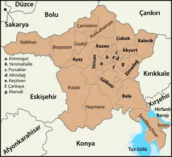
Districts
Ankara has 25 districts.[1]
| Number Plates (İlçe Kayıt) |
District | Population (31.12.2022) |
Area (km²) | Density (per km²) |
|---|---|---|---|---|
| 1872 | Akyurt | 40,625 | 369 | 110 |
| 1130 | Altındağ | 413,994 | 123 | 3,365 |
| 1157 | Ayaş | 12,998 | 1041 | 12 |
| 1167 | Bala | 20,521 | 1,851 | 11 |
| 1187 | Beypazarı | 48,357 | 1,697 | 28 |
| 1227 | Çamlıdere | 8,100 | 782 | 10 |
| 1231 | Çankaya | 942,553 | 483 | 1,951 |
| 1260 | Çubuk | 95,449 | 1,198 | 80 |
| 1302 | Elmadağ | 44,379 | 647 | 69 |
| 1922 | Etimesgut | 614,891 | 273 | 2,252 |
| 1924 | Evren | 2,952 | 222 | 13 |
| 1744 | Gölbaşı | 150,047 | 1,364 | 110 |
| 1365 | Güdül | 8,079 | 540 | 15 |
| 1387 | Haymana | 26,016 | 2,164 | 12 |
| 1815 | Kahramankazan | 59,123 | 547 | 108 |
| 1427 | Kalecik | 12,794 | 1,110 | 12 |
| 1745 | Keçiören | 939,279 | 159 | 5,907 |
| 1473 | Kızılcahamam | 26,872 | 1,623 | 17 |
| 1746 | Mamak | 687,535 | 321 | 2,142 |
| 1539 | Nallıhan | 26,553 | 2,079 | 13 |
| 1578 | Polatlı | 128,378 | 3,618 | 35 |
| 2034 | Pursaklar | 162,389 | 169 | 961 |
| 1747 | Sincan | 572,609 | 880 | 651 |
| 1658 | Şereflikoçhisar | 33,140 | 2,155 | 15 |
| 1723 | Yenimahalle | 704,652 | 219 | 3,218 |
| ANKARA City (9 districts / urban)[6] Altındağ, Çankaya, Etimesgut, Gölbaşı, Keçiören, Mamak, Pursaklar, Sincan, Yenimahalle |
5,187,949 [1] | 3,991 [2] | 1,300 | |
| TOTAL | 5,782,285 [1] | 25,632 [2] | 226 | |
| District | 1965[7] | 1970[8] | 1975[9] | 1980[10] | 1985[11] | 1990[12] | 1997[13] | 2007[14] | 2012[14] | 2017[14] | 2022[14] |
|---|---|---|---|---|---|---|---|---|---|---|---|
| City center[a] | 130,520 | 114,419 | 94,964 | 77,168 | no data | no data | no data | no data | no data | no data | no data |
| Akyurt | no data | no data | no data | no data | no data | 12,535 | 16,229 | 23,354 | 27,201 | 32,863 | 40,625 |
| Altındağ | 229,228 | 348,254 | 526,072 | 624,313 | 406,948 | 422,668 | 394,632 | 370,735 | 363,744 | 371,366 | 413,994 |
| Ayaş | 16,936 | 17,581 | 18,325 | 17,202 | 21,762 | 20,806 | 18,352 | 13,159 | 13,087 | 12,289 | 12,998 |
| Bala | 41,415 | 42,206 | 44,735 | 45,158 | 46,940 | 37,612 | 35,295 | 23,505 | 17,397 | 21,682 | 20,521 |
| Beypazarı | 34,297 | 36,435 | 37,140 | 38,568 | 42,008 | 45,977 | 46,903 | 46,884 | 46,738 | 48,476 | 48,357 |
| Çamlıdere | 19,596 | 18,982 | 19,444 | 18,521 | 18,341 | 19,365 | 20,992 | 9,329 | 6,739 | 7,389 | 8,100 |
| Çankaya | 496,953 | 683,210 | 927,809 | 968,668 | 667,351 | 714,330 | 765,354 | 792,189 | 832,075 | 921,999 | 942,553 |
| Çubuk | 47,601 | 49,539 | 53,114 | 54,616 | 57,716 | 51,964 | 63,700 | 83,826 | 82,614 | 90,063 | 95,449 |
| Elmadağ | 20,526 | 23,852 | 25,893 | 30,354 | 32,967 | 38,032 | 38,682 | 48,013 | 43,856 | 45,513 | 44,379 |
| Etimesgut | no data | no data | no data | no data | no data | 70,800 | 127,395 | 289,601 | 425,947 | 566,500 | 614,891 |
| Evren | no data | no data | no data | no data | no data | 6,928 | 6,506 | 4,027 | 3,011 | 2,753 | 2,952 |
| Gölbaşı | no data | no data | no data | no data | 31,671 | 43,522 | 49,526 | 73,670 | 110,643 | 130,363 | 150,047 |
| Güdül | 18,314 | 18,153 | 18,919 | 15,688 | 19,460 | 18,698 | 22,473 | 10,676 | 8,656 | 8,050 | 8,079 |
| Haymana | 48,908 | 51,256 | 53,275 | 56,171 | 60,823 | 55,527 | 49,730 | 39,310 | 31,058 | 27,277 | 26,016 |
| Kalecik | 28,665 | 29,784 | 27,871 | 28,446 | 27,349 | 25,043 | 25,870 | 17,007 | 13,648 | 12,897 | 12,794 |
| Kahramankazan | no data | no data | no data | no data | no data | 21,837 | 26,076 | 36,147 | 43,308 | 52,079 | 59,123 |
| Keçiören | no data | no data | no data | no data | 443,390 | 536,168 | 615,448 | 843,535 | 840,809 | 917,759 | 939,279 |
| Kızılcahamam | 42,649 | 36,645 | 36,686 | 35,513 | 32,162 | 34,456 | 37,906 | 25,288 | 24,635 | 24,947 | 26,872 |
| Mamak | no data | no data | no data | no data | 379,460 | 410,359 | 405,066 | 503,663 | 559,597 | 637,935 | 687,535 |
| Nallıhan | 31,141 | 32,713 | 32,769 | 34,389 | 35,718 | 36,779 | 39,952 | 31,768 | 30,299 | 28,621 | 26,553 |
| Polatlı | 63,895 | 74,366 | 75,332 | 86,865 | 95,401 | 99,965 | 104,203 | 118,454 | 119,349 | 124,464 | 128,378 |
| Pursaklar | no data | no data | no data | no data | no data | no data | no data | no data | 119,593 | 142,317 | 162,389 |
| Şereflikoçhisar | 69,201 | 75,675 | 82,207 | 79,330 | 87,893 | 60,701 | 55,443 | 34,808 | 35,042 | 33,599 | 33,140 |
| Sincan | no data | no data | no data | no data | 59,451 | 101,118 | 220,415 | 413,030 | 479,454 | 524,222 | 572,609 |
| Yenimahalle | 122,166 | 175,528 | 246,154 | 330,908 | 382,205 | 351,436 | 507,242 | 614,778 | 687,042 | 659,603 | 704,652 |
| Total | 1,644,302 | 2,041,658 | 2,585,293 | 2,854,689 | 3,306,327 | 3,236,626 | 3,693,390 | 4,466,756 | 4,965,542 | 5,445,026 | 5,782,285 |
^a The population of the city center was not included after 1980, due to the fact that Ankara received the metropolitan status.
Geography

Ankara is mostly in the Central Anatolia region, and partly in the Black Sea region. Ankara has mountain forests to its north, and the dry plain of Konya to its south. The province is irrigated by the Kızılırmak and Sakarya River systems, the Sarıyar reservoir and many natural lakes and pools. 50% of the land is used for agriculture, 28% is forest and another 10% is meadow and grazing land. Lake Tuz, the second largest lake in Turkey, partly lies in the Şereflikoçhisar district of the province. The highest point of the province is the 2,015 meters tall Işık Mountain in the Kızılcahamam district.
Climate
The climate is hot and dry in summer, rainy in spring and autumn, cold and snowy in winter, wetter in the north of the province than the drier plains to the south. The annual precipitation in the city of Ankara located the center of the province is 415 mm (16.3 in),[17] the annual precipitation of Kızılcahamam located in the north of the province is 592 mm (1.942 ft), and the annual precipitation of Şereflikoçhisar located in the southeast of the province is 357 mm (14.1 in).[18][19]
Places of interest
See also
- Ankara Vilayet
- Ankara Eyalet
References
- "Address-based population registration system (ADNKS) results dated 31 December 2022, Favorite Reports" (XLS). TÜİK. Retrieved 19 September 2023.
- "İl ve İlçe Yüz ölçümleri". General Directorate of Mapping. Retrieved 19 September 2023.
- Genel Nüfus Sayımları
- tuik
- "The Results of Address Based Population Registration System, 2020". Turkish Statistical Institute. Archived from the original on 2021-10-28. Retrieved 7 December 2021.
- "TURKEY: Ankara City". Citypopulation.de.
- "1965 General Census" (PDF) (in Turkish). Turkish Statistical Institute. 1965. Archived (PDF) from the original on 31 May 2022.
- "1970 General Census" (PDF) (in Turkish). Turkish Statistical Institute. 1970. Archived (PDF) from the original on 10 August 2022.
- "1975 General Census" (PDF) (in Turkish). Turkish Statistical Institute. 1975. Archived (PDF) from the original on 10 August 2022.
- "1980 General Census" (PDF) (in Turkish). Turkish Statistical Institute. 1980. Archived (PDF) from the original on 17 June 2022.
- "1985 General Census" (PDF) (in Turkish). Turkish Statistical Institute. 1986. Archived (PDF) from the original on 22 May 2021.
- "1990 General Census" (PDF) (in Turkish). Turkish Statistical Institute. 1991. Archived (PDF) from the original on 31 August 2021.
- "1997 Population Count" (PDF) (in Turkish). Turkish Statistical Institute. 1999. Archived (PDF) from the original on 30 October 2022.
- "Population Of SRE-1, SRE-2, Provinces and Districts". TÜIK. Retrieved 23 January 2024.
- "Present and future Köppen-Geiger climate classification maps at 1-km resolution". Nature Scientific Data. DOI:10.1038/sdata.2018.214.
- "Present and future Köppen-Geiger climate classification maps at 1-km resolution". Nature Scientific Data. DOI:10.1038/sdata.2018.214.
- "Ankara" (in Turkish). Turkish State Meteorological Service. Retrieved 8 January 2016.
- "Kizilcahamam-Turkey". Weatherbase. Retrieved 14 October 2013.
- "Coğrafi Yapı". Sereflikochisar.gov.tr. Archived from the original on 22 October 2007. Retrieved 10 October 2014.
- "Sarıçalı Dağı Milli Park Olarak İlan Edildi" (in Turkish). Tarım ve Orman Bakanlığı 9. Bölge Müdürlüğü. 28 October 2021. Archived from the original on 10 April 2024. Retrieved 10 April 2024.
External links
| Districts |
|  Districts of Ankara | |||||||||||||||||||||||||
|---|---|---|---|---|---|---|---|---|---|---|---|---|---|---|---|---|---|---|---|---|---|---|---|---|---|---|---|
| |||||||||||||||||||||||||||
Metropolitan municipalities are bolded. | |||||||||||||||||||||||||||