Bayburt Province
Bayburt Province (Turkish: Bayburt ili; Armenian: Բայբեդ գավառ) is a province of Turkey. Located in the Northeast Anatolia region of the country, the capital city is Bayburt. Its area is 3,746 km2,[2] and its population is 84,241 (2022), making it the least-populous province in Turkey.[1] The province was created in 1989 from part of Gümüşhane Province.[3][4]
Bayburt Province
Bayburt ili | |
|---|---|
.jpg.webp) | |
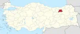 Location of the province within Turkey | |
| Country | Turkey |
| Seat | Bayburt |
| Government | |
| • Governor | Mustafa Eldivan |
| Area | 3,746 km2 (1,446 sq mi) |
| Population (2022)[1] | 84,241 |
| • Density | 22/km2 (58/sq mi) |
| Time zone | UTC+3 (TRT) |
| Area code | 0458 |
| Website | www |
Geography
Bayburt is traversed by the northeasterly line of equal latitude and longitude.
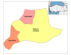
Districts
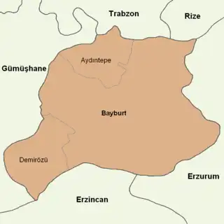
Bayburt province is divided into 3 districts (capital district in bold):
- Aydıntepe
- Bayburt
- Demirözü
Historical sites, places and museums
_(7982346894).jpg.webp)
Goat castle in Bayburt Province.
The most important places in Bayburt Province are:[5]
- Bayburt Tower
- Saruhan Tower
- Aydıntepe underground city
- Mausoleum of Dede Korkut
- Mausoleum of Şehit Osman
- Traditional Bayburt houses
- Ulu Mosque
- Pulur (Gökçedere) Ferahşat Bey Mosque
- Sünür (Çayıryolu) Kutlu Bey Mosque
- Yukarı Hınzeverek (Çatalçeşme) Mosque
- Bedesten (covered bazaar)
- Varzahan Armenian Church
- Baksi Art Museum
- Bayburt Museum
- Kenan Yavuz Etnograpia Museum
Cities and towns
- Bayburt City 32,141 inh.
- Aydıntepe City 2,663 inh.
- Gökçedere Town 2,389 inh.
- Demirözü City 2,137 inh.
- Arpalı Town 1,934 inh.
- Konursu Town 1,569 inh.
Climate
The climate is described as Humid Continental by the Köppen Climate System, abbreviated as Dfb.[6]
See also
- 1993 Bayburt Üzengili avalanche
- Arpalı Kasabası
- List of populated places in Bayburt Province
References
- "Address-based population registration system (ADNKS) results dated 31 December 2022, Favorite Reports" (XLS). TÜİK. Retrieved 19 September 2023.
- "İl ve İlçe Yüz ölçümleri". General Directorate of Mapping. Retrieved 19 September 2023.
- Kanun No. 3578, Resmî Gazete, 21 June 1989.
- "İl İdaresi ve Mülki Bölümler Şube Müdürlüğü İstatistikleri - İl ve İlçe Kuruluş Tarihleri" (PDF) (in Turkish). p. 17. Retrieved 25 October 2023.
- Bayburt Tarihi yerler Archived May 10, 2012, at the Wayback Machine (in Turkish)
- Climate Summary for Bayburt
External links
Wikimedia Commons has media related to Bayburt Province.
- (in Turkish) Bayburt governor's official website
- (in English) Bayburt weather forecast information
| Districts |
|  Districts of Bayburt | |||||||||||||||||||||||||
|---|---|---|---|---|---|---|---|---|---|---|---|---|---|---|---|---|---|---|---|---|---|---|---|---|---|---|---|
| |||||||||||||||||||||||||||
Metropolitan municipalities are bolded. | |||||||||||||||||||||||||||
This article is issued from Wikipedia. The text is licensed under Creative Commons - Attribution - Sharealike. Additional terms may apply for the media files.