Blitar Regency
Blitar Regency is a regency in East Java, Indonesia. It covers an area of 1,558.79 km2 and had a population of 1,116,639 at the 2010 Census[2] and 1,223,745 at the 2020 Census;[3] the official estimate as at mid 2023 was 1,252,242 (comprising 629,098 males and 62,144 females).[1] These figures exclude Blitar city, which is now a separate administrative entity, enclaved within the regency but completely independent from it. Since 2010, the regency's capital has been located in the town of Kanigoro, after sharing the same capital with Blitar city for more than a century.[4]
Blitar Regency | |
|---|---|
 | |
 Coat of arms | |
| Motto(s): Hurub Hambangun Praja "The Spirit Build Country" | |
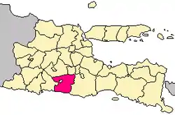 Location within East Java | |
| Coordinates: 8.13333°S 112.25°E | |
| Country | |
| Province | East Java |
| Anniversary | 5 August 1324 |
| Capital | Kanigoro |
| Government | |
| • Regent | Rini Syarifah |
| • Vice Regent | Rahmat Santoso |
| Area | |
| • Total | 1,588.79 km2 (613.44 sq mi) |
| Population (mid 2023 estimate)[1] | |
| • Total | 1,252,242 |
| • Density | 790/km2 (2,000/sq mi) |
| Time zone | UTC+7 (IWST) |
| Area code | (+62) 342 |
| Website | blitarkab.go.id |
History
Blitar Regency as an administrative area is believed to be established in 5 August 1324 AD, during the reign of King Jayanegara (1309-1328).[5]
Administrative districts
Blitar Regency (excluding the city) is divided into twenty-two districts (kecamatan), tabulated below with their areas and their population totals from the 2010 Census[2] and the 2020 Census,[3] together with the official estimates as at mid 2023.[1] The table also includes the number of administrative villages in each district (totaling 220 rural desa and 28 urban kelurahan), and its postal codes. The districts are in each case named after their administrative centre; they are grouped into southern and northern sectors, which have no administrative or legal significance, but highlight the much lower density in the south of the regency (adjoining the sea) compared with the north (centred on Blitar city).
| Kode Wilayah | Name of District (kecamatan) | Area in km2 | Pop'n Census 2010 | Pop'n Census 2020 | Pop'n Estimate mid 2023 | No. of villages | Post code |
|---|---|---|---|---|---|---|---|
| 35.05.05 | Bakung | 111.24 | 25,011 | 27,335 | 28,705 | 11 | 66163 |
| 35.05.08 | Wonotirto (a) | 164.54 | 35,253 | 37,920 | 40,014 | 8 | 66173 |
| 35.05.13 | Panggungrejo (b) | 119.54 | 40,551 | 42,297 | 44,162 | 10 | 66174 |
| 35.05.20 | Wates (c) | 68.76 | 27,688 | 30,151 | 31,453 | 8 | 66194 |
| 35.05.16 | Binangun | 76.79 | 42,717 | 45,862 | 47,263 | 12 | 66193 |
| 35.05.12 | Sutojayan | 44.20 | 46,837 | 51,076 | 52,279 | 11 (d) | 66172 |
| 35.05.04 | Kademangan | 105.28 | 63,519 | 69,712 | 71,833 | 15 (e) | 66161 |
| Totals - South sector | 689.85 | 281,576 | 304,360 | 315,709 | 75 | ||
| 35.05.10 | Kanigoro | 55.55 | 72,919 | 81,769 | 80,697 | 12 (f) | 66171 |
| 35.05.14 | Talun | 49.78 | 59,167 | 65,419 | 66,433 | 14 (g) | 66183 |
| 35.05.22 | Selopuro | 39.29 | 39,319 | 43,900 | 45,431 | 8 | 66184 |
| 35.05.19 | Kesamben | 56.96 | 48,418 | 53,033 | 54,409 | 10 | 66191 |
| 35.05.21 | Selorejo | 52.23 | 34,784 | 38,617 | 39,906 | 10 | 66192 |
| 35.05.18 | Doko | 70.95 | 37,648 | 40,701 | 42,024 | 10 | 66186 |
| 35.05.17 | Wlingi | 66.36 | 49,902 | 53,719 | 55,077 | 9 (h) | 66185 |
| 35.05.15 | Gandusari | 88.23 | 66,337 | 73,240 | 75,205 | 14 | 66187 |
| 35.05.11 | Garum | 65.56 | 62,025 | 68,313 | 68,975 | 9 (i) | 66182 |
| 35.05.09 | Nglegok | 92.56 | 67,479 | 74,807 | 75,570 | 11 (e) | 66181 |
| 35.05.07 | Sanankulon | 33.33 | 53,040 | 57,528 | 57,223 | 12 | 66151 |
| 35.05.06 | Ponggok | 103.83 | 96,783 | 108,169 | 111,575 | 15 | 66153 |
| 35.05.03 | Srengat | 53.98 | 62,071 | 67,715 | 69,259 | 16 (j) | 66152 |
| 35.05.01 | Wonodadi | 40.35 | 45,830 | 49,097 | 50,418 | 11 | 66155 |
| 35.05.02 | Udanawu | 40.98 | 39,341 | 43,365 | 44,331 | 12 | 66154 |
| Totals - North sector | 898.94 | 835,063 | 919,385 | 936,533 | 173 | ||
| Totals - Regency | 1,588.79 | 1,116,639 | 1,223,745 | 1,252,242 | 248 |
Notes: (a) including 7 small offshore islands. (b) including 13 small offshore islands. (c) including 8 small offshore islands.
(d) comprising 7 kelurahan (Jegu, Jingglong, Kalipang, Kedungbunder, Kembangarum, Sukorejo and Sutojayan) and 4 desa.
(e) including one kelurahan - the administrative centre. (f) including 2 kelurahan (Kanigoro and Satreyan).
(g) comprising 4 kelurahan (Bajang, Kamulan, Kaweron and Talun) and 10 desa. (h) comprising 5 kelurahan (Babadan, Beru, Klemunan, Tangkil and Wlingi) and 4 desa.
(i) comprising 4 kelurahan (Bence, Garum, Sumberdiren and Tawangsari) and 5 desa. (j) comprising 4 kelurahan (Dandong, Kauman, Srengat and Togogan) and 12 desa.
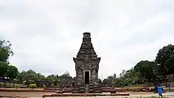
Temples
Because of its strategic location, Blitar has been important for religious activities in the past, especially Hindu. The most famous temple in this area is Candi Penataran located in Penataran village, Nglegok District. According to history, Candi Penataran used to be a temple state or the main temple of the kingdom. Candi Penataran was built when King Kertajaya offered sima to adore sira majesty of Lord Palah in the year 1119 Saka (1197 AD).
Other temples are scattered throughout Blitar, including :
- Candi Bacem
- Candi Gambar Wetan
- Candi Kalicilik
- Candi Kotes
- Candi Sawentar
- Candi Sumbernanas
- Candi Plumbangan
- Candi Simping
- Candi Tepas
- Candi Wringin Branjang
Beaches
- Jolosutro Beach
- Pangi Beach
- Peh Pulo Beach
- Serang Beach
- Tambakrejo Beach
References
- Badan Pusat Statistik, Jakarta, 28 February 2024, Kabupaten Blitar Dalam Angka 2024 (Katalog-BPS 1102001.3505)
- Biro Pusat Statistik, Jakarta, 2011.
- Badan Pusat Statistik, Jakarta, 2021.
- Peraturan Pemerintah Nomor 3 Tahun 2010 tentang Pemindahan ibu kota Kabupaten Blitar dari wilayah Kota Blitar ke wilayah Kecamatan Kanigoro, Kabupaten Blitar, Provinsi Jawa Timur Archived October 1, 2011, at the Wayback Machine
- "Sejarah Kabupaten Blitar". Pemerintah Kabupaten Blitar. 5 June 2012. Retrieved 15 April 2018.
Places adjacent to Blitar Regency | ||||||||||||||||
|---|---|---|---|---|---|---|---|---|---|---|---|---|---|---|---|---|
| ||||||||||||||||
Regencies and cities of East Java | ||
|---|---|---|
Capital: Surabaya | ||
| Regencies |
|  |
| Cities | ||