Bolaang Mongondow Regency
Bolaang Mongondow Regency is a regency of North Sulawesi Province, Indonesia, situated on the island of Sulawesi. The principal town lies at Kotamobagu, which since 2007 has been administratively separated from the regency, the administrative centre of which is now at the town of Lolak. The Regency covers a land area of 2,933.6 km2, and had a population of 213,484 at the 2010 Census[2] and 248,751 at the 2020 Census;[3] the official estimate as at mid 2023 was 254,945 (comprising 132,717 males and 122,228 females).[1]
Bolaang Mongondow Regency
Kabupaten Bolaang Mongondow | |
|---|---|
 Coat of arms | |
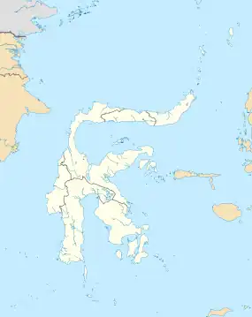
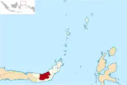 Location within North Sulawesi | |
| Coordinates: 0°57′30″N 124°15′36″E | |
| Country | Indonesia |
| Province | North Sulawesi |
| Capital | Lolak |
| Government | |
| • Regent | Yasti Soepredjo Mokoagow |
| • Vice Regent | Yanny Ronny Tuuk |
| Area | |
| • Total | 2,933.6 km2 (1,132.7 sq mi) |
| Population (mid 2023 estimate)[1] | |
| • Total | 254,945 |
| • Density | 87/km2 (230/sq mi) |
| Time zone | UTC+8 (ICST) |
| Area code | (+62) 434 |
| Website | bolmongkab |
Administrative Districts
Until 2007 the Regency included a much larger share of the territory off North Sulawesi Province, but on 2 January 2007 the town of Kotamobagu was split away to become an independent city, while northern districts of the regency were similarly split off on the same day to create a new North Bolaang Mongondow Regency. On 24 June 2008 two further regencies were created from other parts of the regency - South Bolaang Mongondow and East Bolaang Mongondow. At the time of the 2010 Census the residual Regency was divided into twelve districts (kecamatan), but three additional districts have subsequently been created by splitting of existing districts.
Under consideration by the Indonesian government since 2013 has been a proposal to re-unite the pre-2007 territories into a new province covering the same area as the original Bolaang Mongondow Regency, and separated from North Sulawesi, but all such proposals have been held in abeyance since 2013.
The fifteen districts are tabulated below with their areas and their populations at the 2010 Census[2] and the 2020 Census,[3] together with the official estimates as at mid 2023.[1] The table also includes the location of the district administrative centres, the number of administrative villages in each district, totaling 200 rural desa and 2 urban kelurahan - the latter being Inobonto (in Bolaang District) and Imandi (in Dumoga Timur District) - together with its postal codes.
| Kode Wilayah | Name of District (kecamatan) | Area in km2 | Pop'n Census 2010 | Pop'n Census 2020 | Pop'n Estimate mid 2023 | Admin centre | No. of villages | Post codes |
|---|---|---|---|---|---|---|---|---|
| 71.01.09 | Dumoga Barat (West Dumoga) | 380.5 | 26,520 | 18,514 | 18,207 | Doloduo | 12 | 95731 |
| 71.01.11 | Dumoga Utara (North Dumoga) | 190.4 | 21,410 | 15,085 | 15,089 | Mopuya Utara (North Mopuya) | 16 | 95734 |
| 71.01.10 | Dumoga Timur (East Dumoga) | 173.0 | 32,131 | 21,622 | 21,657 | Modomang | 16 | 95736 |
| 71.01.35 | Dumoga Tengah (Central Dumoga) | 48.4 | (a) | 11,694 | 11,866 | Ibolian | 10 | 95732 |
| 71.01.34 | Dumoga Tenggara (Southeast Dumoga) | 146.3 | (a) | 8,834 | 9,252 | Konarom | 10 | 95735 |
| 71.01.33 | Dumoga | 159.8 | (a) | 15,219 | 15,639 | Pusian | 12 | 95733 |
| 71.01.14 | Lolayan | 260.4 | 23,074 | 26,243 | 27,295 | Tungoi | 14 | 95737 |
| 71.01.19 | Passi Barat (West Passi) | 117.9 | 14,951 | 17,029 | 17,437 | Passi | 13 | 95751 |
| 71.01.22 | Passi Timur (East Passi) | 93.3 | 11,261 | 12,687 | 13,130 | Pangian | 13 | 95750 |
| 71.01.32 | Bilalang | 64.3 | 6,057 | 6,551 | 6,966 | Bilalang IV | 8 | 95755 |
| 71.01.20 | Poigar | 251.0 | 17,033 | 18,754 | 19,566 | Poigar | 20 | 95753 |
| 71.01.13 | Bolaang | 204.7 | 17,143 | 20,692 | 21,063 | Inobonto | 11 | 95752 |
| 71.01.31 | Bolaang Timur (East Bolaang) | 96.8 | 9,608 | 11,829 | 12,501 | Tadoy | 9 | 95754 |
| 71.01.12 | Lolak (b) | 469.2 | 24,740 | 32,342 | 33,753 | Lolak | 26 | 95741 |
| 71.01.05 | Sangtompolang (c) | 277.6 | 9,556 | 11,656 | 11,524 | Maelang | 12 | 95744 |
| Totals | 2,933.6 | 213,484 | 248,751 | 254,945 | 202 |
Notes: (a) the populations at the 2010 Census of the communities now forming these three new districts are included in the figures for the existing districts from which they were cut out. (b) Lolak District includes the offshore islands of Pulau Molosing and Pulau Tikus, situated off the north coast. (c) Sangtompolang District includes the offshore islands of Pulau Gogobola, Pulau Paniki, Pulau Tengah and Pulau Tudunya, all situated off the north coast.
Airport
A new airport was proposed in 2015 as a construction project located in Lolak town. The government allocated IDR250 billion (USD17.2 million) for the project. Construction was scheduled to commence in 2018 and complete by 2021. The airport originally will feature a 1400m runway, later to be extended to 2800m. The detailed airport planning envisages a runway both direction 10-28.[4]
Climate
Lolak has a tropical rainforest climate (Af) with moderate rainfall from July to September and heavy rainfall in the remaining months.
| Climate data for Lolak | |||||||||||||
|---|---|---|---|---|---|---|---|---|---|---|---|---|---|
| Month | Jan | Feb | Mar | Apr | May | Jun | Jul | Aug | Sep | Oct | Nov | Dec | Year |
| Mean daily maximum °C (°F) | 30.1 (86.2) |
30.1 (86.2) |
30.4 (86.7) |
31.1 (88.0) |
31.3 (88.3) |
30.9 (87.6) |
30.8 (87.4) |
31.4 (88.5) |
31.8 (89.2) |
32.0 (89.6) |
31.4 (88.5) |
30.6 (87.1) |
31.0 (87.8) |
| Daily mean °C (°F) | 26.3 (79.3) |
26.3 (79.3) |
26.5 (79.7) |
26.8 (80.2) |
27.2 (81.0) |
26.8 (80.2) |
26.6 (79.9) |
26.8 (80.2) |
26.9 (80.4) |
27.0 (80.6) |
27.0 (80.6) |
26.6 (79.9) |
26.7 (80.1) |
| Mean daily minimum °C (°F) | 22.5 (72.5) |
22.5 (72.5) |
22.6 (72.7) |
22.6 (72.7) |
23.1 (73.6) |
22.7 (72.9) |
22.5 (72.5) |
22.3 (72.1) |
22.0 (71.6) |
22.1 (71.8) |
22.7 (72.9) |
22.7 (72.9) |
22.5 (72.6) |
| Average rainfall mm (inches) | 224 (8.8) |
187 (7.4) |
184 (7.2) |
175 (6.9) |
184 (7.2) |
164 (6.5) |
123 (4.8) |
91 (3.6) |
93 (3.7) |
131 (5.2) |
197 (7.8) |
203 (8.0) |
1,956 (77.1) |
| Source: Climate-Data.org[5] | |||||||||||||
References
- Badan Pusat Statistik, Jakarta, 28 February 2024, Kabupaten Bolaang Mongondow Dalam Angka 2024 (Katalog-BPS 1102001.7101)
- Biro Pusat Statistik, Jakarta, 2011.
- Badan Pusat Statistik, Jakarta, 2021.
- "Pembangunan Bandar Udara di Lolak Bolmong". Retrieved December 1, 2014.
- "Climate: Lolak". Climate-Data.org. Retrieved 22 November 2020.