South Minahasa Regency
South Minahasa Regency is a regency in North Sulawesi, Indonesia. Its capital is the town of Amurang. It was originally part of the Minahasa Regency until it was established as a separate regency on 25 February 2003.[3] In turn, nearly four years later, a new Southeast Minahasa Regency was established as a separate regency from part of the South Minahasa Regency on 2 January 2007.[4] The residual Regency now covers an area of 1,456.74 km2, and had a population of 195,553 at the 2010 Census;[5] this had risen to 236,463 at the 2020 Census;[6] the official estimate as at mid 2023 was 244,590.[2]
South Minahasa Regency
(Kabupaten Minahasa Selatan) | |
|---|---|
 Coat of arms | |
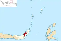 Location in North Sulawesi | |
 South Minahasa Regency Location in Indonesia | |
| Coordinates: 0°35′N 124°18′E | |
| Country | Indonesia |
| Province | North Sulawesi |
| Established | 25 February 2003 |
| Capital | Amurang |
| Government | |
| • Regent | Franky Donny Wongkar |
| • Vice Regent | Petra Yanni Rembang |
| Area | |
| • Total | 1,456.74 km2 (562.45 sq mi) |
| Population (mid 2023 estimate)[2] | |
| • Total | 244,590 |
| • Density | 170/km2 (430/sq mi) |
| Time zone | UTC+8 (WITA) |
| Website | minselkab.go.id |
Administration
The regency is divided into seventeen districts (kecamatan), tabulated below with their areas and population totals from the 2010 Census[5] and the 2020 Census,[6] together with the official estimates as at mid 2023.[2] The table also includes the locations of the administrative centres, the number of administrative villages in each district (totaling 163 rural desa and 14 urban kelurahan), and its postal codes.
| Kode Wilayah | Name of District (kecamatan) | Area in km2 | Pop'n Census 2010 | Pop'n Census 2020 | Pop'n Estimate mid 2023 | Admin centre | No. of villages | Post codes |
|---|---|---|---|---|---|---|---|---|
| 71.05.01 | Modoinding | 53.37 | 11,324 | 13,748 | 14,232 | Pinasungkulan | 10 | 95958 |
| 71.05.02 | Tompaso Baru | 105.41 | 11,774 | 13,511 | 13,763 | Tompaso Baru Dua | 10 | 95358 |
| 71.05.16 | Maesaan | 140.03 | 9,717 | 12,020 | 12,511 | Tumani Utara | 12 | 95357 |
| 71.05.03 | Ranoyapo | 93.68 | 11,832 | 14,361 | 14,866 | Pontak Satu | 12 | 95944 |
| 21.05.07 | Motoling | 23.88 | 7,191 | 8,650 | 8,931 | Motoling | 7 (a) | 95941 |
| 21.05.15 | Kumelembuai | 45.42 | 6,650 | 7,847 | 8,056 | Kumelembuai Satu | 8 | 95956 |
| 71.05.21 | Motoling Barat (West Motoling) | 110.90 | 7,661 | 9,655 | 10,104 | Raanon Baru Dua | 8 | 95942 |
| 71.05.22 | Motoling Timur (East Motoling) | 68.25 | 8,673 | 10,277 | 10,564 | Wanga Amongena | 8 | 95943 |
| 71.05.08 | Sinonsayang | 133.31 | 15,203 | 18,860 | 19,647 | Ongkaw Dua | 13 | 95959 |
| 71.05.09 | Tenga | 122.98 | 17,184 | 21,522 | 22,482 | Pakuweru | 18 | 95355 |
| 71.05.10 | Amurang | 66.37 | 16,260 | 18,182 | 18,378 | Buyungon | 8 (b) | 95957 |
| 71.05.17 | Amurang Barat (West Amurang) | 87.63 | 14,898 | 17,307 | 17,689 | Kapitu | 10 (c) | 95955 |
| 71.05.18 | Amurang Timur (East Amurang) | 113.36 | 13,390 | 16,455 | 17,029 | Lopana | 10 (d) | 95954 |
| 71.05.13 | Tareran | 65.77 | 12,129 | 14,234 | 14,591 | Rumoong Atas | 13 | 95953 |
| 71.05.23 | Suluun Tareran ("Sulta") | 40.54 | 7,098 | 8,169 | 8,326 | Suluun Empat | 9 | 95952 |
| 71.05.12 | Tumpaan | 73.33 | 15,434 | 20,095 | 21,229 | Tumpaan Satu | 10 | 95352 |
| 71.05.19 | Tatapaan (e) | 111.52 | 8,965 | 11,570 | 12,192 | Paslaten | 11 | 95351 |
| Totals | 1,456.74 | 195,553 | 236,463 | 244,590 | Amurang | 177 |
Notes: (a) comprises 4 kelurahan (Motoling, Motoling Dua, Motoling Mawale and Motoling Satu) and 3 desa.
(b) comprises 6 kelurahan (Bitung, Buyungon, Lewet, Ranoyapo, Uwuran I and Uwuran II) and 2 desa.
(c) comprises 2 kelurahan (Kawangkoan Bawah and Rumoong Bawah) and 8 desa.
(d) comprises 2 kelurahan (Pondang and Ranomea) and 8 desa. (e) including 4 small offshore islands.
Climate
Amurang, the seat of the regency has a tropical rainforest climate (Af) with moderate rainfall from July to September and heavy rainfall in the remaining months.
| Climate data for Amurang | |||||||||||||
|---|---|---|---|---|---|---|---|---|---|---|---|---|---|
| Month | Jan | Feb | Mar | Apr | May | Jun | Jul | Aug | Sep | Oct | Nov | Dec | Year |
| Mean daily maximum °C (°F) | 29.6 (85.3) |
29.6 (85.3) |
29.9 (85.8) |
30.9 (87.6) |
31.0 (87.8) |
30.9 (87.6) |
30.9 (87.6) |
31.5 (88.7) |
31.7 (89.1) |
31.8 (89.2) |
30.9 (87.6) |
30.2 (86.4) |
30.7 (87.3) |
| Daily mean °C (°F) | 26.0 (78.8) |
26.0 (78.8) |
26.2 (79.2) |
26.7 (80.1) |
26.9 (80.4) |
26.8 (80.2) |
26.7 (80.1) |
26.9 (80.4) |
26.8 (80.2) |
27.0 (80.6) |
26.7 (80.1) |
26.4 (79.5) |
26.6 (79.9) |
| Mean daily minimum °C (°F) | 22.4 (72.3) |
22.4 (72.3) |
22.6 (72.7) |
22.5 (72.5) |
22.9 (73.2) |
22.7 (72.9) |
22.5 (72.5) |
22.4 (72.3) |
22.0 (71.6) |
22.2 (72.0) |
22.6 (72.7) |
22.7 (72.9) |
22.5 (72.5) |
| Average rainfall mm (inches) | 331 (13.0) |
263 (10.4) |
243 (9.6) |
205 (8.1) |
187 (7.4) |
170 (6.7) |
124 (4.9) |
97 (3.8) |
99 (3.9) |
138 (5.4) |
224 (8.8) |
280 (11.0) |
2,361 (93) |
| Source: Climate-Data.org[7] | |||||||||||||
References
- Badan Pusat Statistik, Jakarta, 2023, Kabupaten Minahasa Selatan Dalam Angka 2023 (Katalog-BPS 1102001.7105)
- Badan Pusat Statistik, Jakarta, 28 February 2024, Kabupaten Minahasa Selatan Dalam Angka 2024 (Katalog-BPS 1102001.7105)
- RI, Setjen DPR. "Dewan Perwakilan Rakyat". www.dpr.go.id. Archived from the original on 24 November 2009. Retrieved 27 June 2017.
- Undang-Undang Republik Indonesia Nomor 9 Tahun 2007 Archived 2012-01-07 at the Wayback Machine
- Biro Pusat Statistik, Jakarta, 2011.
- Badan Pusat Statistik, Jakarta, 2021.
- "Climate: Amurang". Climate-Data.org. Retrieved 22 November 2020.