List of cities and towns in Jamaica
The following is a list of the most populous settlements in Jamaica.
Definitions
The following definitions have been used:
- City: Official city status on a settlement is only conferred by Act of Parliament. Only three areas have the designation; Kingston when first incorporated in 1802[1][2] reflecting its early importance over the then capital Spanish Town, Montego Bay being granted the status in 1980,[3][4][5][6] and Portmore, whose municipal council was given the city title in 2018.[7] It is not necessarily based on population counts, and while a honorific title, can confer some increased autonomy.
- Town/Village: The Statistical Institute of Jamaica considers an urban area to be any area with 2,000 or more residents.[8] A town would generally be considered to be ranked as a higher populated urban area, and a village as a minor urban area.
- Neighbourhood: Geographically obvious subdivisions of any of the above.
Cities and towns
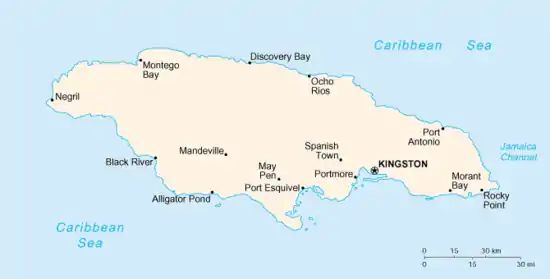
A map of Jamaica, with main settlements and notable places
Cities
| Name | Census population[9] | Coordinates | Parish | Granted | ||
|---|---|---|---|---|---|---|
| 2021 | 2011 | 2001 | ||||
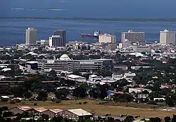
| Kingston** | 584,627 | 579,137 | 17.98°N 76.80°W | Kingston | 1802 | |
| Portmore | 182,153 | 156,469 | 17.94°N 76.87°W | Saint Catherine | 2018 | |
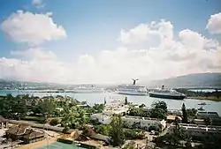
| Montego Bay* | 110,115 | 96,477 | 18.46°N 77.91°W | Saint James | 1980 | |
** Country and parish capital
* Parish capital
Chief towns
These are settled areas with 10,000 residents or more.
| Name | Census population[9] | Coordinates | Parish | ||
|---|---|---|---|---|---|
| 2021 | 2011 | 2001 | |||
| Spanish Town* | 147,152 | 131,515 | 17.99°N 76.95°W | Saint Catherine | |
| May Pen* | 61,548 | 57,334 | 17.97°N 77.24°W | Clarendon | |
| Mandeville* | 49,695 | 47,467 | 18.05°N 77.48°W | Manchester | |
| Old Harbour | 28,912 | 23,823 | 17.92°N 77.10°W | Saint Catherine | |
| Savanna-la-Mar* | 22,633 | 19,893 | 18.16°N 77.95°W | Westmoreland | |
| Ocho Rios | 16,671 | 15,769 | 18.42°N 77.11°W | Saint Ann | |
| Linstead | 15,231 | 15,660 | 18.15°N 77.02°W | Saint Catherine | |
| Port Antonio* | 14,816 | 14,568 | 18.16°N 76.38°W | Portland | |
| Saint Ann's Bay* | 11,173 | 10,441 | 18.44°N 77.22°W | Saint Ann | |
| Morant Bay* | 11,052 | 10,782 | 17.87°N 76.39°W | Saint Thomas | |
| Yallahs | 10,849 | 9,888 | 17.87°N 76.57°W | Saint Thomas | |
| Hayes | 10,639 | 10,098 | 17.88°N 77.25°W | Clarendon | |
| Santa Cruz | 10,423 | 10,785 | 18.07°N 77.72°W | Saint Elizabeth | |
Towns and villages
| Name | Census population[9] | Coordinates | Parish | ||
|---|---|---|---|---|---|
| 2011 | 2001 | 1991 | |||
| Above Rocks | 3,076 | 3,170 | 3,263 | 18.10°N 76.87°W | Saint Catherine |
| Aenon Town | 1,374 | 1,808 | 18.20°N 77.39°W | Clarendon | |
| Adelphi | 2,218 | 1,459 | 18.44°N 77.79°W | Saint James | |
| Albert Town | 3,845 | 3,949 | 3,389 | 18.29°N 77.54°W | Trelawny |
| Alexandria | 1,693 | 1,734 | 1,672 | 18.29°N 77.35°W | Saint Ann |
| Alligator Pond | 2,541 | 1,883 | 1,542 | 17.87°N 77.56°W | Manchester |
| Alston | 2,049 | 1,666 | 18.17°N 77.43°W | Clarendon | |
| Anchovy | 4,414 | 4,081 | 3,633 | 18.40°N 77.93°W | Saint James |
| Annotto Bay | 6,017 | 5,423 | 5,468 | 18.27°N 76.77°W | Saint Mary |
| Balaclava | 2,770 | 2,703 | 2,837 | 18.17°N 77.64°W | Saint Elizabeth |
| Bamboo | 4,705 | 4,298 | 3,732 | 18.38°N 77.26°W | Saint Ann |
| Bath | 2,115 | 2,144 | 2,151 | 17.95°N 76.35°W | Saint Thomas |
| Bethel Town | 4,198 | 3,232 | 2,768 | 18.30°N 77.95°W | Westmoreland |
| Black River* | 5,352 | 4,095 | 3,675 | 18.03°N 77.86°W | Saint Elizabeth |
| Bluefields | 2,978 | 3,132 | 2,564 | 18.17°N 78.03°W | Westmoreland |
| Bog Walk | 9,431 | 11,241 | 8,794 | 18.10°N 77.02°W | Saint Catherine |
| Brown's Town | 9,031 | 8,054 | 6,762 | 18.40°N 77.36°W | Saint Ann |
| Buff Bay | 4,678 | 4,210 | 2,596 | 18.23°N 76.67°W | Portland |
| Bull Savanna | 3,747 | 3,457 | 17.88°N 77.59°W | Saint Elizabeth | |
| Cambridge | 4,073 | 3,966 | 3,384 | 18.32°N 77.89°W | Saint James |
| Cascade | 812 | 866 | 1,220 | 18.40°N 78.10°W | Hanover |
| Carron Hall | 1,186 | 1,293 | 18.27°N 76.94°W | Saint Mary | |
| Cave Valley | 1,500 | 1,722 | 1,777 | 18.27°N 77.37°W | Saint Ann |
| Cedar Valley | 1,299 | 1,592 | 17.99°N 76.58°W | Saint Thomas | |
| Chapelton | 4,363 | 4,556 | 3,930 | 18.08°N 77.27°W | Clarendon |
| Christiana | 8,430 | 8,276 | 7,235 | 18.17°N 77.49°W | Manchester |
| Claremont | 1,773 | 1,970 | 2,154 | 18.38°N 77.17°W | Saint Ann |
| Clark's Town | 3,003 | 3,953 | 3,139 | 18.42°N 77.57°W | Trelawny |
| Coleyville | 2,016 | 2,098 | 3,320 | 18.22°N 77.50°W | Manchester |
| Comfort Castle | 893 | 856 | 18.05°N 76.41°W | Portland | |
| Constant Spring | 11,801 | 12,072 | 12,369 | 18.05°N 76.78°W | Saint Andrew |
| Croft's Hill | 3,117 | 3,202 | 2,994 | 18.13°N 77.22°W | Clarendon |
| Cross Keys | 1,869 | 2,057 | 17.89°N 77.50°W | Manchester | |
| Dalvey | 2,952 | 3,263 | 2,742 | 17.90°N 76.25°W | Saint Thomas |
| Darliston | 2,328 | 2,529 | 1,435 | 18.23°N 77.97°W | Westmoreland |
| Dias | 1,653 | 1,434 | 18.39°N 78.19°W | Hanover | |
| Discovery Bay | 2,446 | 2,518 | 2,230 | 18.47°N 77.39°W | Saint Ann |
| Duncans | 2,686 | 2,132 | 1,849 | 18.47°N 77.53°W | Trelawny |
| Easington | 2,664 | 2,326 | 2,378 | 17.92°N 76.60°W | Saint Thomas |
| Ewarton | 9,753 | 10,807 | 8,742 | 18.18°N 77.08°W | Saint Catherine |
| Falmouth* | 8,686 | 8,188 | 7,245 | 18.49°N 77.66°W | Trelawny |
| Frankfield | 3,507 | 3,625 | 2,865 | 18.15°N 77.35°W | Clarendon |
| Frome | 1,306 | 968 | 900 | 18.30°N 78.15°W | Westmoreland |
| Gayle | 3,260 | 4,148 | 3,205 | 18.33°N 77.00°W | Saint Mary |
| Gimme-Me-Bit | 883 | 1,076 | 17.89°N 77.28°W | Clarendon | |
| Glengoffe | 3,100 | 3,232 | 18.14°N 76.88°W | Saint Catherine | |
| Golden Grove | 2,351 | 2,622 | 2,761 | 17.93°N 76.27°W | Saint Thomas |
| Gordon Town | 3,265 | 3,846 | 1,049 | 18.05°N 76.70°W | Saint Andrew |
| Grange Hill | 6,922 | 7,591 | 6,530 | 18.37°N 78.20°W | Westmoreland |
| Green Island | 1,933 | 1,539 | 1,591 | 18.38°N 78.27°W | Hanover |
| Guy's Hill | 763 | 518 | 3,165 | 18.25°N 77.00°W | Saint Mary |
| Half Way Tree* | 5,163 | 4,934 | 18.01°N 76.78°W | Saint Andrew | |
| Hector's River | 1,617 | 1,578 | 18.00°N 76.26°W | Portland | |
| Highgate | 6,375 | 6,051 | 5,418 | 18.32°N 76.87°W | Saint Mary |
| Hope Bay | 1,759 | 1,774 | 1,569 | 18.20°N 76.57°W | Portland |
| Hopewell | 5,651 | 4,759 | 4,268 | 18.25°N 78.30°W | Hanover |
| Islington | 3,983 | 2,973 | 2,868 | 18.32°N 76.85°W | Saint Mary |
| Jackson Town | 2,143 | 1,718 | 18.41°N 77.48°W | Trelawny | |
| James Hill | 1,404 | 1,770 | 18.18°N 77.34°W | Clarendon | |
| Johns Hall | 3,217 | 2,329 | 18.41°N 77.85°W | Saint James | |
| Junction | 4,034 | 3,524 | 17.90°N 77.60°W | Saint Elizabeth | |
| Kellits | 2,106 | 2,422 | 2,291 | 18.17°N 77.23°W | Clarendon |
| Kemps Hill | 573 | 1,132 | 17.85°N 77.28°W | Clarendon | |
| Lacovia | 3,788 | 3,125 | 3,159 | 18.07°N 77.75°W | Saint Elizabeth |
| Lionel Town | 3,609 | 3,568 | 4,669 | 17.80°N 77.23°W | Clarendon |
| Little London | 4,222 | 4,312 | 1,848 | 18.30°N 78.20°W | Westmoreland |
| Lluidas Vale | 2,095 | 2,552 | 2,161 | 18.12°N 77.15°W | Saint Catherine |
| Long Bay | 976 | 1,074 | 18.09°N 76.31°W | Portland | |
| Lucea* | 7,840 | 6,245 | 6,002 | 18.44°N 78.18°W | Hanover |
| Lucky Hill | 3,260 | 4,148 | 750 | 18.30°N 77.02°W | Saint Mary |
| Maggotty | 1,727 | 1,099 | 1,359 | 18.15°N 77.77°W | Saint Elizabeth |
| Malvern | 2,817 | 3,056 | 3,262 | 17.97°N 77.72°W | Saint Elizabeth |
| Manchioneal | 2,383 | 2,316 | 2,185 | 18.05°N 76.28°W | Portland |
| Maroon Town | 2,673 | 3,206 | 2,669 | 18.35°N 77.79°W | Saint James |
| Mavis Bank | 2,309 | 2,432 | 1,756 | 18.02°N 76.67°W | Saint Andrew |
| Mile Gully | 2,004 | 2,134 | 18.13°N 77.54°W | Manchester | |
| Milk River | 1,564 | 842 | 17.87°N 77.35°W | Clarendon | |
| Mitchell Town | 1,452 | 1,749 | 17.80°N 77.19°W | Clarendon | |
| Mocho | 1,531 | 1,788 | 18.02°N 77.32°W | Clarendon | |
| Moneague | 3,464 | 3,383 | 2,880 | 18.28°N 77.10°W | Saint Ann |
| Moore Town | 1,061 | 1,317 | 1,054 | 18.07°N 76.43°W | Portland |
| Mountainside | 1,754 | 1,097 | 17.98°N 77.74°W | Saint Elizabeth | |
| Nain | 2,969 | 2,506 | 2,373 | 17.97°N 77.60°W | Saint Elizabeth |
| Negril | 7,680 | 5,679 | 4,184 | 18.32°N 78.33°W | Westmoreland |
| 152 | 184 | Hanover | |||
| New Market | 2,204 | 1,775 | 18.14°N 77.90°W | Saint Elizabeth | |
| Newell | 2,056 | 1,836 | 17.92°N 77.74°W | Saint Elizabeth | |
| Newport | 3,022 | 2,495 | 17.96°N 77.50°W | Manchester | |
| Old Harbour Bay | 5,872 | 6,344 | 5,405 | 17.90°N 77.10°W | Saint Catherine |
| Oracabessa | 4,398 | 4,230 | 4,066 | 18.40°N 76.93°W | Saint Mary |
| Osbourne Store | 3,580 | 2,954 | 3,390 | 17.97°N 77.33°W | Clarendon |
| Petersfield | 5,037 | 3,699 | 2,045 | 18.25°N 78.07°W | Westmoreland |
| Point Hill | 2,099 | 2,235 | 3,651 | 18.08°N 77.10°W | Saint Catherine |
| Port Morant | 2,905 | 3,007 | 17.88°N 76.32°W | Saint Thomas | |
| Port Maria* | 7,463 | 7,439 | 7,651 | 18.37°N 76.89°W | Saint Mary |
| Port Royal | 1,251 | 1,651 | 3,004 | 17.93°N 76.85°W | Kingston |
| Porus | 6,009 | 5,924 | 5,095 | 18.03°N 77.42°W | Manchester |
| Pratville | 1,963 | 1,351 | 17.91°N 77.41°W | Manchester | |
| Race Course | 2,958 | 3,168 | 2,589 | 17.83°N 77.28°W | Clarendon |
| Ramble | 2,047 | 2,024 | 18.35°N 77.97°W | Hanover | |
| Retreat | 3,034 | 2,759 | 18.39°N 77.02°W | Saint Mary | |
| Richmond | 2,086 | 2,210 | 1,984 | 18.23°N 76.90°W | Saint Mary |
| Rio Bueno | 1,037 | 1,275 | 1,108 | 18.46°N 77.45°W | Trelawny |
| Riversdale | 2,514 | 3,575 | 2,791 | 18.15°N 76.97°W | Saint Catherine |
| Rock River | 1,786 | 1,831 | 18.07°N 77.21°W | Clarendon | |
| Rocky Point | 2,473 | 3,327 | 2,744 | 17.77°N 77.27°W | Clarendon |
| Runaway Bay | 8,640 | 5,840 | 5,655 | 18.45°N 77.33°W | Saint Ann |
| Sandy Bay | 5,052 | 3,817 | 4,476 | 18.45°N 78.10°W | Hanover |
| Seaforth | 5,287 | 5,517 | 4,108 | 17.93°N 76.45°W | Saint Thomas |
| Siloah | 2,545 | 2,755 | 2,701 | 18.17°N 77.71°W | Saint Elizabeth |
| Southfield | 3,854 | 3,404 | 2,671 | 17.88°N 77.67°W | Saint Elizabeth |
| Spalding | 4,373 | 3,225 | 5,481 | 18.14°N 77.41°W | Manchester |
| 2,147 | 2,645 | Clarendon | |||
| Stony Hill | 9,307 | 9,242 | 8,244 | 18.08°N 76.78°W | Saint Andrew |
| Thompson Town | 2,310 | 2,383 | 18.08°N 77.36°W | Clarendon | |
| Toll Gate | 2,800 | 3,087 | 17.97°N 77.35°W | Clarendon | |
| Trinity Ville | 1,239 | 2,338 | 2,614 | 17.95°N 76.53°W | Saint Thomas |
| Troja | 1,019 | 1,394 | 18.20°N 76.92°W | Saint Catherine | |
| Ulster Spring | 841 | 995 | 1,391 | 18.32°N 77.52°W | Trelawny |
| Wakefield | 3,373 | 3,019 | 2,724 | 18.42°N 77.72°W | Trelawny |
| Wait-A-Bit | 3,157 | 3,439 | 18.24°N 77.52°W | Trelawny | |
| Watt Town | 434 | 538 | 18.30°N 77.41°W | Saint Ann | |
| White House | 4,211 | 3,498 | 3,157 | 18.08°N 77.97°W | Westmoreland |
| Williamsfield | 3,327 | 4,251 | 2,800 | 18.07°N 77.48°W | Manchester |
| York Town | 1,623 | 2,075 | 17.94°N 77.27°W | Clarendon | |
Villages
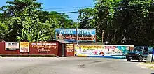
White River Rafting signs
- Accompong (Saint Elizabeth)
- Aeolus Valley (Saint Thomas)
- Airy Castle (Saint Thomas)
- Barking Lodge (Saint Thomas)
- Berry Hill (Manchester)
- Bog (Westmoreland)
- Big Woods (Westmoreland)
- Boscobel (Saint Mary)
- Bull Bay (Saint Andrew)
- Carmel (Westmoreland)
- Cattawood Springs (Portland)
- Clarendon Park (Clarendon)
- Cotterwood (Saint Elizabeth)
- Duckenfield (Saint Thomas)
- Four Paths (Clarendon)
- Haddersfield (Saint Mary)
- Hagley Gap (Saint Thomas)
- Hodges (Saint Elizabeth)
- Hopewell Hall (Saint Thomas)
- Hopewell (Clarendon)
- Hopewell (Manchester)
- Hopewell (Saint Andrew)
- Hopewell (Saint Ann)
- Hopewell (Saint Elizabeth)
- Hopewell (Westmoreland)
- Hopeton (Westmoreland)
- Knockpatrick (Manchester)
- Lloyds (Saint Thomas)
- Long Wood (Saint Elizabeth)
- Mavis Bank (Saint Andrew)
- Meadsfield (Manchester)
- Middle Quarters (Saint Elizabeth)
- Mount Rosser (Saint Catherine)
- Nanny Town (Portland)
- New Holland (Saint Elizabeth)
- New Market (Saint Elizabeth)
- New Roads (Saint Elizabeth)
- Newcastle (Saint Andrew)
- Nine Mile (Saint Ann)
- Old Pera (Saint Thomas)
- Paynes Town (Saint Elizabeth)
- Port Esquivel (Saint Catherine)
- Port Morant (Saint Thomas)
- Roxborough (Manchester)
- San San (Portland)
- Sheckles Pen (Clarendon)
- Stonehenge (Saint James)
- Walderston
- White Hall (Saint Elizabeth)
- Wood Hall (Saint Catherine)
Neighbourhoods
Kingston & St. Andrew
- Barbican
- Allerdyce
- Cherry Gardens
- Belgrade Mews
- Smokey Vale
- Constant Spring
- Denham Town
- Tivoli Gardens
- Jones Town
- Kencot
- Allman Town
- Rae Town
- Downtown Kingston
- Red Hills
- Stony Hill
- Mountain View
- Forest Gardens
- Forest Hills
- Forest Hills Gardens
- Duhaney Park
- Patrick City
- Patrick Gardens
- Washington Gardens
- Norbrook
- Queen Hill
- Meadowbrook
- Meadowbrook Estates
- Pembroke Hall
- Half Way Tree
- Eastwood Park Gardens
- Harbour View
- Port Royal
- Liguanea
- Mona
- Ithaca
- Papine
- Kintyre
- Beverley Hills
- Long Mountain
- New Kingston
- Trafalgar Park
- Hope Pastures
- Jack's Hill
- Riva Ridge
- Cross Roads
- Norbrook
- Trenchtown
- Riverton Meadows
- Seaview Gardens
- Callaloo Bed
- New Haven
- Waterhouse
- Backto
- Payne Land
- Olympic Garden
- Cockburn Gardens
- Greenwich Town
- Whitfield Town
- Marverley
- Pembrook Hall
- Zaidie Gardens
- Hughenden
- Havendale
- Molynes Gardens
- Vineyard Town
- Woodford Park
- Franklyn Town
- Eden Gardens
- Bournemouth Gardens
- Norman Gardens
- August Town
- College Common
- Elletson Flats
References
- "The Laws of Jamaica: 1799-1803". A. Aikman, printer to the King's Most Excellent Majesty. 1812.
- "A Special Gleaner Feature on Pieces of the Past - The Capital City Kingston -The first 500 years in Jamaica". old.jamaica-gleaner.com.
- "Montego Bay (Status of City) Act | Ministry of Justice - Government of Jamaica".
- "Parish profiles - Jamaica Information Service". jis.gov.jm. Retrieved 16 July 2019.
- "Major Jamaican Cities & Towns - Including the Largest City in Jamaica". My-Island-Jamaica.com. Retrieved 16 July 2019.
- "Jamaica Observer Limited". Jamaica Observer. Retrieved 16 July 2019.
- "It's now Portmore City Municipality". jamaica-gleaner.com. 3 November 2018. Retrieved 16 July 2019.
- "Urban centres grow by 5 per cent". Jamaica Observer. Retrieved 16 July 2019.
- "Population and Housing Census 2011: General Report Volume 1". statinja.gov.jm. Retrieved 19 March 2023.
External links
Wikimedia Commons has media related to Populated places in Jamaica.
- World Gazetteer, Jamaica: Largest cities and towns with statistics of their population at archive.today (archived 2012-12-05)
- World Gazetteer, Jamaica: Maps at archive.today (archived 2013-02-09)
- Origin of Jamaican Place names
For the definition of city, town, etc., see: Settlements in Jamaica. | |||||
| Cities | |||||
| Towns |
| ||||
| Villages |
| ||||
| Neighbourhoods |
| ||||
This article is issued from Wikipedia. The text is licensed under Creative Commons - Attribution - Sharealike. Additional terms may apply for the media files.