Central Plains Region
The Central Plains Region (French: Région des plaines centrales) is an informal geographic region of the Canadian province of Manitoba located in the south central part of the Canadian province of Manitoba, directly west of Winnipeg.[2]
Central Plains Region | |
|---|---|
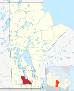 Map of the Central Plains Region in Manitoba. | |
| Country | |
| Province | |
| Area | |
| • Total | 10,655.94 km2 (4,114.28 sq mi) |
| Population | |
| • Total | 51,129 |
| • Density | 4.8/km2 (12/sq mi) |
.JPG.webp)
Crescent Lake in Portage la Prairie
Its major urban centre is the City of Portage la Prairie. Together with the Pembina Valley Region to the south, the Central Plains Region composes the broader cultural region of Central Manitoba.[2][3] Geographically, the region is considered to be a part of southern Manitoba, and is serviced by the Southern Regional Health Authority.
As of the 2016 census, the region had a population of 50,300 (compared to 48,289 in the 2001 census).[4][5][6]
Major communities
.jpg.webp)
Happy Rock in Gladstone
- Portage la Prairie (city)
Rural municipalities and communities
| Rural municipality | Unincorporated communities | Census division |
|---|---|---|
| Cartier |
|
No. 10 |
| Grey |
|
No. 9 |
| Glenella-Lansdowne |
|
No. 8 |
| Lorne |
|
No. 8 (partly in No. 4) |
| Macdonald |
|
No. 10 |
| Norfolk Treherne |
|
No. 8 |
| North Norfolk |
|
No. 8 |
| Portage la Prairie |
|
No. 9 |
| St. François Xavier | No. 10 | |
| Victoria |
|
No. 8 |
| WestLake – Gladstone |
|
No. 8 |
First Nations and reserves
- Dakota Plains First Nation (Dakota Plains 6A, Dakota Tipi 1)
- Long Plain First Nation
- Sandy Bay 5
Points of interest
- Parks and wetlands
- Delta Marsh
- Portage Spillway Provincial Park
- Spruce Woods Provincial Park
- St. Ambroise Beach Provincial Park
- Stephenfield Provincial Park
- Twin Lakes Beach
- Yellow Quill Provincial Park
- Other
- Manitoba Agricultural Museum
- Prairie Wind Music Festival
- Transport
- Portage la Prairie/Southport Airport
- 3 Canadian Forces Flying Training School
- KF Defence Programs
- Portage la Prairie (North) Airport
- Manitoba Highway 13
- Manitoba Highway 100
- Provincial Road 242
- Provincial Road 248
- Provincial Road 305
- Portage la Prairie/Southport Airport
References
- "North Central economic region statistics". Statistics Canada. Retrieved March 27, 2023.
- "Manitoba's Tourist Regions". MACAP. Retrieved 2021-08-03.
- "In Your Community". Manitoba Parent Zone - Healthy Child Manitoba. Retrieved 2021-08-03.
- Statistics Canada (2017-02-08). "Division No. 9, Census division [Census division], Manitoba and Manitoba [Province] | Census Profile, 2016 Census". www12.statcan.gc.ca. Archived from the original on 2021-08-03. Retrieved 2021-08-03.
- Statistics Canada (2017-02-08). "Division No. 8, Census division [Census division], Manitoba and Manitoba [Province] | Census Profile, 2016 Census". www12.statcan.gc.ca. Archived from the original on 2021-08-03. Retrieved 2021-08-03.
- Statistics Canada (2017-02-08). "Division No. 10, Census division [Census division], Manitoba and Manitoba [Province] | Census Profile, 2016 Census". www12.statcan.gc.ca. Archived from the original on 2019-06-27. Retrieved 2021-08-03.
External links
- Central Manitoba Tourism
- Central Plains Regional Profile
- Community Profile: Census Division No. 8, Manitoba; Statistics Canada Archived 2007-03-10 at the Wayback Machine
- Community Profile: Census Division No. 9, Manitoba; Statistics Canada Archived 2007-03-10 at the Wayback Machine
- Community Profile: Census Division No. 10, Manitoba; Statistics Canada Archived 2007-03-10 at the Wayback Machine
Places adjacent to Central Plains Region | ||||||||||||||||
|---|---|---|---|---|---|---|---|---|---|---|---|---|---|---|---|---|
| ||||||||||||||||
Subdivisions of Manitoba | |||
|---|---|---|---|
| Subdivisions |
| ||
| Regions | |||
| Cities | |||
| Towns |
| ||
| Villages |
| ||
| |||
This article is issued from Wikipedia. The text is licensed under Creative Commons - Attribution - Sharealike. Additional terms may apply for the media files.