Parkland Region
Parkland is an informal geographic region of the Canadian province of Manitoba, located between Lakes Manitoba and Winnipegosis on the east and the Manitoba–Saskatchewan border on the west.
Parkland Region | |
|---|---|
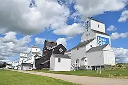 The grain elevator row in Inglis, Manitoba, a national historic site. | |
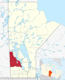 Map of the Parkland Region of Manitoba. | |
| Country | |
| Province | |
| Area | |
| • Total | 28,163.15 km2 (10,873.85 sq mi) |
| Population | |
| • Total | 41,575 |
| • Density | 1.5/km2 (3.8/sq mi) |
The largest population centre is the city of Dauphin, and the second largest is the town of Swan River. Riding Mountain National Park, Duck Mountain Provincial Park, and Asessippi Provincial Park are also located in the region, as well as Manitoba's highest point, Baldy Mountain.
Together with the Westman Region to the south, Parkland composes the broader Prairie Mountain region,[2] and is provided health services via Prairie Mountain Health.[3] As of 2021, the Parkland region had a population of 41,575.
Major communities
Urban municipalities:
- Dauphin (city)
- Swan River (town)
- Unorganized Division No. 17
- Unorganized North Division No. 20
- Unorganized South Division No. 20
Rural municipalities and communities
| Rural municipality | Unincorporated communities | Census division[4] |
|---|---|---|
| Alonsa |
|
No. 17 |
| Dauphin |
|
No. 17 |
| Ethelbert |
|
No. 17 |
| Gilbert Plains |
|
No. 17 |
| Grandview |
|
No. 17 |
| Lakeshore |
|
No. 17 |
| McCreary |
|
No. 17 |
| Minitonas – Bowsman | No. 20 | |
| Mossey River |
|
No. 17 |
| Mountain |
|
No. 20 |
| Riding Mountain West |
|
No. 16 |
| Roblin |
|
No. 16 |
| Rossburn |
|
No. 16 |
| Russell – Binscarth | No. 16 | |
| Ste. Rose |
|
No. 17 |
| Swan Valley West |
|
No. 20 |
First Nations and reserves
- Ebb and Flow (Ebb and Flow 52)
- Gambler (Gambler 63, partly)
- Tootinaowaziibeeng
- Valley River 63A
- Waywayseecappo
Recreation and points of interest
Parks and geography
- Asessippi Provincial Park
- Asessippi Ski Area — Manitoba's largest ski resort[5]
- Dauphin Lake
- Duck Mountain Provincial Forest
- Duck Mountain Provincial Park
- Baldy Mountain — Manitoba's highest peak[5]
- Manipogo Provincial Park
- Riding Mountain Biosphere Reserve
- Shellmouth Reservoir
- Thunderhill Ski Area
- Valley River
Transport
- Dauphin station
- Gilbert Plains station
- Grandview railway station
- Laurier railway station
- Lt. Col W.G. (Billy) Barker VC Airport
- Ochre River station
- Roblin railway station
- Ste. Rose du Lac Airport
- Provincial Trunk Highways 5, 10, 16, 20, and 83
- Swan River Airport
Recreation and other
- Assiniboine Community College (satellite campus)
- Credit Union Place
- Dauphin’s Countryfest
- Inglis Grain Elevators National Historic Site
- Richardson Recreation and Wellness Centre
- Swan River Centennial Arena
- Waywayseecappo Wolverines Complex
Sports teams
- Dauphin Kings
- Swan Valley Stampeders
- Waywayseecappo Wolverines
References
- "Parklands economic region statistics". Statistics Canada. Retrieved March 27, 2023.
- "In Your Community". Manitoba Parent Zone - Healthy Child Manitoba. Retrieved 2021-08-03.
- Government of Canada, Statistics Canada (2015-12-16). "Health Regions: Boundaries and Correspondence with Census Geography". www150.statcan.gc.ca. Retrieved 2021-08-03.
- Government of Canada, Statistics Canada (2013-04-05). "Economic Regions - SGC 2006 - Classification structure - 4670 - Parklands". www23.statcan.gc.ca. Retrieved 2021-08-03.
- "Parkland Region | Places To Go". Travel Manitoba. Retrieved 2021-08-03.
External links
- Parkland Regional Profile
- Parkland Tourism Archived 2015-05-12 at the Wayback Machine
- Community Profile: Census Division No. 16, Manitoba; Statistics Canada
- Community Profile: Census Division No. 17, Manitoba; Statistics Canada
- Community Profile: Census Division No. 20, Manitoba; Statistics Canada
Subdivisions of Manitoba | |||
|---|---|---|---|
| Subdivisions |
| ||
| Regions | |||
| Cities | |||
| Towns |
| ||
| Villages |
| ||
| |||
This article is issued from Wikipedia. The text is licensed under Creative Commons - Attribution - Sharealike. Additional terms may apply for the media files.