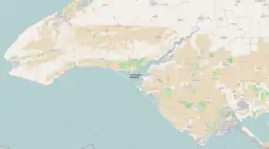
Donuzlav
Lake Donuzlav (Russian and Ukrainian: Донузлав, Crimean Tatar: Doñuzlav), also referred to as Donuzlav Bay, is the deepest lake[1] of Crimea (27 m, 89 ft) and biggest in Chornomorske Raion (47 km2, 18 sq mi). It is a protected landscape and recreational park of the Autonomous Republic of Crimea.
| Donuzlav | |
|---|---|
| Донузлав, Doñuzlav | |
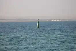 Donuzlav Lake near Novoozerne | |
.jpg.webp) Donuzlav | |
| Location | Crimea |
| Coordinates | 45°20′24″N 33°00′36″E |
The lake is as salty as the sea near its mouth but bottom springs make the water much less saline near the head.
Overview
Technically it is no longer a lake but rather a bay since 1961, when a 200-metre width canal was washed through the sandy peresyp separating it from the Black Sea, when the construction of a Soviet naval base started.[2] The peresyp length is about 12 km (7.5 mi) with widths varying between 0.3 km (980 ft) to 1 km (3,300 ft).[3][1]
Donuzlav is located in Chornomorske and Saky raions (districts) at the Tarkhankut Peninsula[1] as well as Yevpatoria Municipality. Donuzlav is one of several lakes located around the peninsula.[1]
The length of Donuzlav is 30 km (19 mi), a width is up to 8.5 km (5.3 mi), an area of 42 km2 (16 sq mi) and a depth is up to 27 m (89 ft).[1] It has several small bays.[1] Banks are high, steep, and winding.[1] At separate parts of the lake, a wetland vegetation is common (i.e. common reed, cattail, others).[1]
In the upper portion of the lakes are located two dams for fish farming, in the mid portion is a naval base.[1] On the banks there is a wind-powered energy station (Sakska Wind Farm) with 53 wind turbines.[1]
To the lake are headed several gulches (semi-dried streams) among which are Staryi Donuzlav, Donuzlav, Chernushka, and Burnuk.
In the northern part there is a Donuzlav recreational park of area 2,335 hectares.
Settlements
- Novoozerne, Yevpatoria Municipality
- Myrnyi, Yevpatoria Municipality
- Ozerivka, Chornomorske Raion
- Krasnoyarske, Chornomorske Raion
Military bases
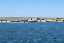
Donuzlav was the location of the Crimean Naval Base of the Soviet Union. The base was particularly notable for housing air-cushioned landing craft (Zubr class). After the dissolution of the Soviet Union it was converted into the Southern Naval Base of Armed Forces of Ukraine.
On 5 March 2014, during the Crimean crisis of 2014, Russian sailors scuttled two Russian Black Sea Fleet vessels, the anti-submarine ship Ochakov and the rescue tugboat Shakhter, at the entrance to Donuzlav Bay to prevent Ukrainian Navy ships from accessing the Black Sea[4][5][6][7] and established the Russian naval base there, reinstating its previous name.
Early on 1 February 2024, Ivanovets, a Russian Tarantul-class corvette, was sunk in Lake Donuzlav after an attack by surface drones.[8][9]
The Soviets also established the Donguzlav air base near the lake. It was decommissioned in 1995, but has been reused by the Russian military since the Russo-Ukrainian war.[10][11][12]
See also
- Cherkasy, a film
References
- Oliferov, A.M. Donuzlav (ДОНУЗЛА́В). Encyclopedia of Modern Ukraine.
- https://xn----ttbgfagjn8f.xn--p1ai/ozero-donuzlav-interesnye-fakty/
- https://xn----ttbgfagjn8f.xn--p1ai/ozero-donuzlav-interesnye-fakty/
- Defence Express 05.03.2014
- "Large ASW Destroyer "Ochakov" - Project 1134B / Kara class". Flot.sevastopol.info. Retrieved 2014-04-23.
- "Спасательное буксирное судно "Шахтер" Черноморского Флота". Flot.sevastopol.info. Retrieved 2014-04-23.
- "В Крыму затоплен российский большой противолодочный корабль "Очаков" • Таймер". Timer.od.ua. Retrieved 2014-04-23.
- "Military intelligence: Russian missile ship sunk off occupied Crimea". The Kyiv Independent. 1 February 2024. Retrieved 1 February 2024.
- Greenall, Robert (1 February 2024). "Ukraine 'hits Russian missile boat Ivanovets in Black Sea'". BBC News. Retrieved 1 February 2024.
- "Десятки российских вертолетов замечены вблизи озера Донузлав в Крыму – спутниковый снимок". Крым.Реалии (in Russian). 2022-02-15. Archived from the original on 2023-07-19. Retrieved 2023-07-19.
- "Новые спутниковые снимки войск России в Крыму и у границ Украины". Азаттык Υналгысы. Archived from the original on 2023-07-19. Retrieved 2023-07-19.
- Свобода, Радіо. "Мапа російських військових об'єктів в Криму". Радіо Свобода (in Ukrainian). Archived from the original on 2023-07-19. Retrieved 2023-07-19.
Further reading
- Yegiazarov, V. At Donuzlav. Notes of underwater hunter (На Донузлаве. Заметки подводного охотника). "Berega Tavridy", 2001.
| Botanical nature reserves |
|  |
|---|---|---|
| Geological nature reserves |
| |
| Hydrological nature reserves |
| |
| Landscape nature reserves |
| |
| Forest nature reserves |
| |
| Ornithological nature reserves |
| |
Categories of protected areas of Ukraine The Crimean peninsula is recognised internationally as part of Ukraine, but is under Russian occupation since 2014. | ||