Haram, Norway
Haram is a municipality in Møre og Romsdal county, Norway. It is part of the Sunnmøre region. The administrative center is Brattvåg, the industrial center of Sunnmøre. Other important villages in the municipality include Austnes, Eidsvik, Helle, Longva, Hildrestranda, Søvik, Tennfjord, and Vatne.
Haram Municipality
Haram kommune | |
|---|---|
| Harham herred (historic name) | |
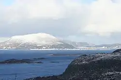 View of Lepsøy | |
 Flag  Coat of arms | |
 Møre og Romsdal within Norway | |
 Haram within Møre og Romsdal | |
| Coordinates: 62°34′03″N 06°22′20″E | |
| Country | Norway |
| County | Møre og Romsdal |
| District | Sunnmøre |
| Established | 1 Jan 1838 |
| • Created as | Formannskapsdistrikt |
| Disestablished | 1 Jan 2020 |
| • Succeeded by | Ålesund Municipality |
| Re-established | 1 Jan 2024 |
| • Preceded by | Ålesund Municipality |
| Administrative centre | Brattvåg |
| Government | |
| • Mayor (2023) | Vebjørn Krogsæter (Sp) |
| Area | |
| • Total | 261.14 km2 (100.83 sq mi) |
| • Land | 254.30 km2 (98.19 sq mi) |
| • Water | 6.84 km2 (2.64 sq mi) 2.6% |
| • Rank | #294 in Norway |
| Population (2018) | |
| • Total | 9,345 |
| • Rank | #122 in Norway |
| • Density | 36.7/km2 (95/sq mi) |
| • Change (10 years) | |
| Demonyms | Harams-mann Harams-kvinne Haramsøying[1] |
| Official language | |
| • Norwegian form | Nynorsk |
| Time zone | UTC+01:00 (CET) |
| • Summer (DST) | UTC+02:00 (CEST) |
| ISO 3166 code | NO-1534[3] |
| Website | Official website |
The 261-square-kilometre (101 sq mi) municipality is the 294th largest by area out of the 422 municipalities in Norway. Haram is the 122nd most populous municipality in Norway with a population of 9,345. The municipality's population density is 36.7 inhabitants per square kilometre (95/sq mi) and its population has increased by 8.4% over the last decade.[4][5]
Brattvåg IL is a sports club based in the municipality. Tennfjord Mannskor is a male choir from the village of Tennfjord. The Ulla Lighthouse and Hellevik Lighthouse are both located in the northwestern part of the municipality.
General information
The parish of Haram was established as a municipality on 1 January 1838 (see formannskapsdistrikt law). The western island district of Roald was separated from Haram on 1 January 1890 to form the new municipality of Roald. This left 1,956 people left in Haram.[6]
During the 1960s, there were many municipal mergers across Norway due to the work of the Schei Committee. On 1 January 1965, three municipal changes involving Haram occurred:
- The part of Haram Municipality on the island of Harøya, including the Myklebost area and the smaller surrounding islands to the west of there (population: 287), was separated from Haram Municipality and merged into the neighboring Sandøy Municipality to the northeast.
- Most of Vatne Municipality (population: 2,260) to the southeast of Haram Municipality was merged into Haram Municipality.
- The Søvik area in Borgund Municipality (population: 1,191) to the south of Haram Municipality were merged into Haram.
These three boundary changes created a much larger municipality of Haram.[6]
On 1 January 2020, the neighboring municipalities of Haram, Skodje, Ørskog, Sandøy, and Ålesund were merged to form a new, large municipality of Ålesund. This occurred because in June 2017, the Parliament of Norway voted to approve the merger.[7] Soon after the merger, there was discontent among the people who had lived in the old Haram municipality. After lots of discussions, the municipal council of the new Ålesund petitioned the government to reverse that part of the merger and split Haram off as a separate municipality once again. On 3 October 2022, the Parliament of Norway approved a law to split Haram off as a separate municipality effective on 1 January 2024.[8]
Name
The municipality (originally the parish) is named after the old Haram farm (Old Norse: Harhamarr) since the first Haram Church was built there. The first element is prefix har- which has an unknown meaning. The last element is hamarr which means "stone" or "steep cliff". Prior to 1889, the name was written Harham.[9]
Coat of arms
The coat of arms was granted on 7 August 1987 and it was in use until 2020 when the municipality ceased to exist. The official blazon is "Per fess engrailed of three lobes argent and azure" (Norwegian: Delt av sølv og blått med omvend bogesnitt med tre bogar). This means the arms have are divided with a horizontal line that is engrailed three times. The field (background) below the line has a tincture of azure. Above the line, the field has a tincture of argent which means it is commonly colored white, but if it is made out of metal, then silver is used. The design was chosen to look like three waves, symbolizing the importance of the sea in this island municipality. The arms were designed by Eldar Tandstad. The municipal flag has the same design as the coat of arms.[10][11][12]
Dialect
The dialect of the area was well known for its practice of H-dropping and the old and traditional pronunciation of the name of the municipality was [a:ram].
Churches
The Church of Norway has four parishes (sokn) within the municipality of Haram. It is part of the Nordre Sunnmøre prosti (deanery) in the Diocese of Møre.
| Parish (sokn) | Church name | Location of the church | Year built |
|---|---|---|---|
| Haram og Fjortoft | Haram Church | Austnes | 1838 |
| Lepsøy Chapel | Lepsøya | 1896 | |
| Fjørtoft Church | Fjørtofta | 1878 | |
| Vatne | Vatne Church | Vatne | 1868 |
| Hamnsund | Hamnsund Church | just south of Søvik | 1875 |
| Brattvåg | Brattvåg Church | Brattvåg | 1977 |
| Hildre Church | Hildrestranda | 1905 |
Geography
The municipality of Haram includes many islands including Bjørnøya, Fjørtofta, Haramsøya, Løvsøya, Skuløya, and Terøya. The islands of Bjørnøya and Terøya are connected to the mainland via causeways. The islands of Haramsøya and Skuløya are connected with the Ullasund Bridge. The rest of the islands have ferry connections to the mainland. The new Nordøyvegen bridge and tunnel network will connect all of the main islands of Haram to the mainland when it is completed in 2022. The Haramsfjorden, Vatnefjorden, and Romsdal Fjord all flow through the municipality.
The municipality shares land borders with Vestnes Municipality to the east and Skodje Municipality to the south. The rest of the municipality is surrounded by sea. The municipality also borders (by sea) Sandøy Municipality and Midsund Municipality to the northeast, Ålesund Municipality to the south, and Giske Municipality to the west.
Government
Haram Municipality is responsible for primary education (through 10th grade), outpatient health services, senior citizen services, welfare and other social services, zoning, economic development, and municipal roads and utilities. The municipality is governed by a municipal council of directly elected representatives. The mayor is indirectly elected by a vote of the municipal council.[13] The municipality is under the jurisdiction of the Møre og Romsdal District Court and the Frostating Court of Appeal.
Municipal council
The municipal council (Kommunestyre) of Haram is made up of 27 representatives that are elected to four year terms. The tables below show the current and historical composition of the council by political party.
| Party name (in Nynorsk) | Number of representatives | |
|---|---|---|
| Labour Party (Arbeidarpartiet) | 3 | |
| Progress Party (Framstegspartiet) | 4 | |
| Conservative Party (Høgre) | 4 | |
| Industry and Business Party (Industri‑ og Næringspartiet) | 3 | |
| Christian Democratic Party (Kristeleg Folkeparti) | 1 | |
| Centre Party (Senterpartiet) | 9 | |
| Socialist Left Party (Sosialistisk Venstreparti) | 1 | |
| Liberal Party (Venstre) | 2 | |
| Total number of members: | 27 | |
| Note: On 1 January 2024, the municipality was re-established after being separated from Ålesund Municipality. | ||
| Party name (in Nynorsk) | Number of representatives | |
|---|---|---|
| Labour Party (Arbeidarpartiet) | 5 | |
| Progress Party (Framstegspartiet) | 6 | |
| Green Party (Miljøpartiet Dei Grøne) | 1 | |
| Conservative Party (Høgre) | 5 | |
| Christian Democratic Party (Kristeleg Folkeparti) | 3 | |
| Centre Party (Senterpartiet) | 6 | |
| Liberal Party (Venstre) | 1 | |
| Total number of members: | 27 | |
| Note: On 1 January 2020, the municipality became part of Ålesund Municipality. | ||
| Party name (in Nynorsk) | Number of representatives | |
|---|---|---|
| Labour Party (Arbeidarpartiet) | 5 | |
| Progress Party (Framstegspartiet) | 4 | |
| Conservative Party (Høgre) | 8 | |
| Christian Democratic Party (Kristeleg Folkeparti) | 3 | |
| Centre Party (Senterpartiet) | 5 | |
| Liberal Party (Venstre) | 1 | |
| Independent election list for Haram (Uavhengig valliste for Haram) | 5 | |
| Total number of members: | 31 | |
| Party name (in Nynorsk) | Number of representatives | |
|---|---|---|
| Labour Party (Arbeidarpartiet) | 4 | |
| Progress Party (Framstegspartiet) | 5 | |
| Conservative Party (Høgre) | 10 | |
| Christian Democratic Party (Kristeleg Folkeparti) | 3 | |
| Centre Party (Senterpartiet) | 6 | |
| Socialist Left Party (Sosialistisk Venstreparti) | 1 | |
| Liberal Party (Venstre) | 2 | |
| Independent election list for Haram (Uavhengig valliste for Haram) | 6 | |
| Total number of members: | 37 | |
| Party name (in Nynorsk) | Number of representatives | |
|---|---|---|
| Labour Party (Arbeidarpartiet) | 5 | |
| Progress Party (Framstegspartiet) | 5 | |
| Conservative Party (Høgre) | 6 | |
| Christian Democratic Party (Kristeleg Folkeparti) | 3 | |
| Centre Party (Senterpartiet) | 8 | |
| Socialist Left Party (Sosialistisk Venstreparti) | 2 | |
| Liberal Party (Venstre) | 2 | |
| Independent election list for Haram (Uavhengig valliste for Haram) | 6 | |
| Total number of members: | 37 | |
| Party name (in Nynorsk) | Number of representatives | |
|---|---|---|
| Labour Party (Arbeidarpartiet) | 5 | |
| Progress Party (Framstegspartiet) | 4 | |
| Conservative Party (Høgre) | 7 | |
| Christian Democratic Party (Kristeleg Folkeparti) | 6 | |
| Centre Party (Senterpartiet) | 6 | |
| Socialist Left Party (Sosialistisk Venstreparti) | 2 | |
| Liberal Party (Venstre) | 3 | |
| Independent election list for Haram (Uavhengig valliste for Haram) | 4 | |
| Total number of members: | 37 | |
| Party name (in Nynorsk) | Number of representatives | |
|---|---|---|
| Labour Party (Arbeidarpartiet) | 6 | |
| Progress Party (Framstegspartiet) | 3 | |
| Conservative Party (Høgre) | 4 | |
| Christian Democratic Party (Kristeleg Folkeparti) | 8 | |
| Centre Party (Senterpartiet) | 5 | |
| Socialist Left Party (Sosialistisk Venstreparti) | 1 | |
| Liberal Party (Venstre) | 5 | |
| Søvik and Gamlem list (Søvik og Gamlem liste) | 4 | |
| Haramsøy list (Haramsøy liste) | 1 | |
| Total number of members: | 37 | |
| Party name (in Nynorsk) | Number of representatives | |
|---|---|---|
| Labour Party (Arbeidarpartiet) | 4 | |
| Progress Party (Framstegspartiet) | 1 | |
| Conservative Party (Høgre) | 5 | |
| Christian Democratic Party (Kristeleg Folkeparti) | 4 | |
| Centre Party (Senterpartiet) | 2 | |
| Socialist Left Party (Sosialistisk Venstreparti) | 3 | |
| Liberal Party (Venstre) | 3 | |
| Søvik, Gamlem, and Grytestrand list (Søvik, Gamlem og Grytestrand liste) | 5 | |
| Lepsøy list (Lepsøy liste) | 2 | |
| Haramsøy list (Haramsøy liste) | 2 | |
| Vestrefjord, Vatne, and Tennfjord list (Vestrefjord, Vatne og Tennfjord liste) | 6 | |
| Total number of members: | 37 | |
| Party name (in Nynorsk) | Number of representatives | |
|---|---|---|
| Labour Party (Arbeidarpartiet) | 8 | |
| Conservative Party (Høgre) | 7 | |
| Christian Democratic Party (Kristeleg Folkeparti) | 7 | |
| Centre Party (Senterpartiet) | 1 | |
| Socialist Left Party (Sosialistisk Venstreparti) | 1 | |
| Liberal Party (Venstre) | 3 | |
| Lepsøy list (Lepsøy liste) | 2 | |
| Haramsøy list (Haramsøy liste) | 2 | |
| Vestrefjord, Vatne, and Tennfjord list (Vestrefjord, Vatne og Tennfjord liste) | 6 | |
| Total number of members: | 37 | |
| Party name (in Nynorsk) | Number of representatives | |
|---|---|---|
| Labour Party (Arbeidarpartiet) | 9 | |
| Conservative Party (Høgre) | 7 | |
| Christian Democratic Party (Kristeleg Folkeparti) | 8 | |
| Centre Party (Senterpartiet) | 2 | |
| Socialist Left Party (Sosialistisk Venstreparti) | 1 | |
| Liberal Party (Venstre) | 3 | |
| Haramsøy list (Haramsøy liste) | 3 | |
| Vestrefjord, Vatne, and Tennfjord list (Vestrefjord, Vatne og Tennfjord liste) | 4 | |
| Total number of members: | 37 | |
| Party name (in Nynorsk) | Number of representatives | |
|---|---|---|
| Labour Party (Arbeidarpartiet) | 6 | |
| Conservative Party (Høgre) | 8 | |
| Christian Democratic Party (Kristeleg Folkeparti) | 8 | |
| New People's Party (Nye Folkepartiet) | 1 | |
| Centre Party (Senterpartiet) | 5 | |
| Socialist Left Party (Sosialistisk Venstreparti) | 1 | |
| Liberal Party (Venstre) | 3 | |
| Election list for Vestfjord, Vatne, and Tennfjord (Valliste for Vestrefjord, Vatne og Tennfjord) | 4 | |
| Election list for Skuløy, Flemsøy, Haramsøy, and Lepsøy (Valliste for Skuløy, Flemsøy, Haramsøy og Lepsøy) | 1 | |
| Total number of members: | 37 | |
| Party name (in Nynorsk) | Number of representatives | |
|---|---|---|
| Labour Party (Arbeidarpartiet) | 5 | |
| Conservative Party (Høgre) | 4 | |
| Christian Democratic Party (Kristeleg Folkeparti) | 7 | |
| New People's Party (Nye Folkepartiet) | 1 | |
| Centre Party (Senterpartiet) | 8 | |
| Socialist Left Party (Sosialistisk Venstreparti) | 1 | |
| Liberal Party (Venstre) | 4 | |
| Election list for Vestfjord, Vatne, and Tennfjord (Valliste for Vestrefjord, Vatne og Tennfjord) | 3 | |
| Election list for Gamlem, Søvik, and Grytestranda (Valliste for Gamlem, Søvik og Grytestranda) | 2 | |
| Election list for Lepsøy (Valliste for Lepsøy) | 2 | |
| Total number of members: | 37 | |
| Party name (in Nynorsk) | Number of representatives | |
|---|---|---|
| Labour Party (Arbeidarpartiet) | 7 | |
| Conservative Party (Høgre) | 2 | |
| Christian Democratic Party (Kristeleg Folkeparti) | 7 | |
| Centre Party (Senterpartiet) | 5 | |
| Socialist People's Party (Sosialistisk Folkeparti) | 1 | |
| Liberal Party (Venstre) | 6 | |
| Local List(s) (Lokale lister) | 9 | |
| Total number of members: | 37 | |
| Party name (in Nynorsk) | Number of representatives | |
|---|---|---|
| Labour Party (Arbeidarpartiet) | 7 | |
| Conservative Party (Høgre) | 1 | |
| Christian Democratic Party (Kristeleg Folkeparti) | 7 | |
| Centre Party (Senterpartiet) | 3 | |
| Socialist People's Party (Sosialistisk Folkeparti) | 1 | |
| Liberal Party (Venstre) | 7 | |
| Local List(s) (Lokale lister) | 11 | |
| Total number of members: | 37 | |
| Party name (in Nynorsk) | Number of representatives | |
|---|---|---|
| Labour Party (Arbeidarpartiet) | 2 | |
| Local List(s) (Lokale lister) | 19 | |
| Total number of members: | 21 | |
| Party name (in Nynorsk) | Number of representatives | |
|---|---|---|
| Labour Party (Arbeidarpartiet) | 2 | |
| Local List(s) (Lokale lister) | 19 | |
| Total number of members: | 21 | |
| Party name (in Nynorsk) | Number of representatives | |
|---|---|---|
| Local List(s) (Lokale lister) | 21 | |
| Total number of members: | 21 | |
| Party name (in Nynorsk) | Number of representatives | |
|---|---|---|
| Labour Party (Arbeidarpartiet) | 1 | |
| Local List(s) (Lokale lister) | 19 | |
| Total number of members: | 20 | |
| Party name (in Nynorsk) | Number of representatives | |
|---|---|---|
| Local List(s) (Lokale lister) | 20 | |
| Total number of members: | 20 | |
| Party name (in Nynorsk) | Number of representatives | |
|---|---|---|
| Labour Party (Arbeidarpartiet) | 4 | |
| Local List(s) (Lokale lister) | 16 | |
| Total number of members: | 20 | |
| Party name (in Nynorsk) | Number of representatives | |
|---|---|---|
| Labour Party (Arbeidarpartiet) | 5 | |
| Local List(s) (Lokale lister) | 15 | |
| Total number of members: | 20 | |
| Note: Due to the German occupation of Norway during World War II, no elections were held for new municipal councils until after the war ended in 1945. | ||
Mayors
The mayors (Nynorsk: ordførar) of Haram:[32][33]
- 1837–1841: Sjur Olsen Hatlemark
- 1842–1851: Carl Sjursen Haram
- 1852–1857: Nils Rasmussen Aakre
- 1858–1862: Jens Kobro Daae
- 1863–1867: Nils Rasmussen Aakre
- 1868–1878: Hans Rasmussen Vestre
- 1879–1900: Nils Ingebrigtsen Alvestad (V)
- 1901–1911: Nils Nilsen Aakre (V)
- 1911–1912: Knudt Severin Jonas Olsen Otterlei (V)
- 1913–1921: Ole Rasmus Knutsen Flem (V)
- 1922–1925: Knudt Severin Jonas Olsen Otterlei (V)
- 1926–1928: Martinus Eriksen Otterlei
- 1929–1934: Karl Gunnarson Rogne (V)
- 1935–1941: Ole Johanson Skjelten
- 1941–1945: Martinus Kjerstad (NS)
- 1945–1955: Lars Larsson Fjørtoft (V)
- 1984–1985: Robert Hurlen (H)
- 1986–1988: Svein Ottar Sandal (KrF)
- 1989–1989: Knut Wahl (Ap)
- 1990–1991: Robert Hurlen (H)
- 1992–1999: Margrethe Tennfjord (KrF)
- 1999–2007: Oddbjørn Vatne (Sp)
- 2007–2015: Bjørn Sandnes (H)
- 2015–2019: Vebjørn Krogsæter (Sp)
- (2020-2023: Haram Municipality was merged into Ålesund Municipality)
- 2024-present: Vebjørn Krogsæter (Sp)
Media gallery
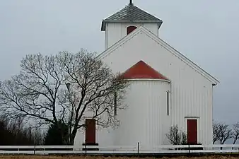 Hildre Church near Brattvåg
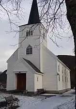 Hamnsund Church near Søvik
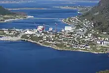
 View of Brattvåg village
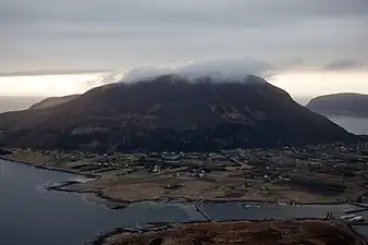 View of Lepsøya island
References
- "Navn på steder og personer: Innbyggjarnamn" (in Norwegian). Språkrådet.
- "Forskrift om målvedtak i kommunar og fylkeskommunar" (in Norwegian). Lovdata.no.
- Bolstad, Erik; Thorsnæs, Geir, eds. (26 January 2023). "Kommunenummer". Store norske leksikon (in Norwegian). Kunnskapsforlaget.
- Statistisk sentralbyrå (2018). "Table: 06913: Population 1 January and population changes during the calendar year (M)" (in Norwegian). Retrieved 4 August 2019.
- Statistisk sentralbyrå. "09280: Area of land and fresh water (km²) (M)" (in Norwegian). Retrieved 4 August 2019.
- Jukvam, Dag (1999). Historisk oversikt over endringer i kommune- og fylkesinndelingen (PDF) (in Norwegian). Statistisk sentralbyrå. ISBN 9788253746845.
- "Om nye Ålesund: Bakgrunn" (in Norwegian). Nye Ålesund kommune. Retrieved 14 October 2017.
- "Forskrift om gjennomføring av deling av Ålesund kommune til Haram kommune og Ålesund kommune". Lovdata.no (in Norwegian). 3 October 2022. Retrieved 2 April 2023.
- Rygh, Oluf (1908). Norske gaardnavne: Romsdals amt (in Norwegian) (13 ed.). Kristiania, Norge: W. C. Fabritius & sønners bogtrikkeri. p. 206.
- "Civic heraldry of Norway - Norske Kommunevåpen". Heraldry of the World. Retrieved 2 April 2023.
- "Haram, Møre og Romsdal". Flags of the World. Retrieved 2 April 2023.
- "Godkjenning av våpen og flagg". Lovdata.no (in Norwegian). Norges kommunal- og arbeidsdepartementet. 7 August 1987. Retrieved 2 April 2023.
- Hansen, Tore; Vabo, Signy Irene, eds. (20 September 2022). "kommunestyre". Store norske leksikon (in Norwegian). Kunnskapsforlaget. Retrieved 14 October 2022.
- "Kommunestyrevalg 2023 - Møre og Romsdal". Valgdirektoratet. Retrieved 16 January 2024.
- "Table: 04813: Members of the local councils, by party/electoral list at the Municipal Council election (M)" (in Norwegian). Statistics Norway.
- "Kommunestyrevalg 2011 - Møre og Romsdal" (in Norwegian). Statistics Norway. Retrieved 19 October 2019.
- "Kommunestyrevalget 1995" (PDF) (in Norwegian). Oslo-Kongsvinger: Statistisk sentralbyrå. 1996. Retrieved 26 April 2020.
- "Kommunestyrevalget 1991" (PDF) (in Norwegian). Oslo-Kongsvinger: Statistisk sentralbyrå. 1993. Retrieved 26 April 2020.
- "Kommunestyrevalget 1987" (PDF) (in Norwegian). Oslo-Kongsvinger: Statistisk sentralbyrå. 1988. Retrieved 26 April 2020.
- "Kommunestyrevalget 1983" (PDF) (in Norwegian). Oslo-Kongsvinger: Statistisk sentralbyrå. 1984. Retrieved 26 April 2020.
- "Kommunestyrevalget 1979" (PDF) (in Norwegian). Oslo: Statistisk sentralbyrå. 1979. Retrieved 26 April 2020.
- "Kommunevalgene 1975" (PDF) (in Norwegian). Oslo: Statistisk sentralbyrå. 1977. Retrieved 26 April 2020.
- "Kommunevalgene 1972" (PDF) (in Norwegian). Oslo: Statistisk sentralbyrå. 1973. Retrieved 26 April 2020.
- "Kommunevalgene 1967" (PDF) (in Norwegian). Oslo: Statistisk sentralbyrå. 1967. Retrieved 26 April 2020.
- "Kommunevalgene 1963" (PDF) (in Norwegian). Oslo: Statistisk sentralbyrå. 1964. Retrieved 26 April 2020.
- "Kommunevalgene og Ordførervalgene 1959" (PDF) (in Norwegian). Oslo: Statistisk sentralbyrå. 1960. Retrieved 26 April 2020.
- "Kommunevalgene og Ordførervalgene 1955" (PDF) (in Norwegian). Oslo: Statistisk sentralbyrå. 1957. Retrieved 26 April 2020.
- "Kommunevalgene og Ordførervalgene 1951" (PDF) (in Norwegian). Oslo: Statistisk sentralbyrå. 1952. Retrieved 26 April 2020.
- "Kommunevalgene og Ordførervalgene 1947" (PDF) (in Norwegian). Oslo: Statistisk sentralbyrå. 1948. Retrieved 26 April 2020.
- "Kommunevalgene og Ordførervalgene 1945" (PDF) (in Norwegian). Oslo: Statistisk sentralbyrå. 1947. Retrieved 26 April 2020.
- "Kommunevalgene og Ordførervalgene 1937" (PDF) (in Norwegian). Oslo: Statistisk sentralbyrå. 1938. Retrieved 26 April 2020.
- Rogne, M (1937). "Kommunestyringa 1837–1937". Haram og Vigra kommune 1837–1937 (in Norwegian). Ålesund: Sunnmørspostens bok- og aksidenstrykkeri. p. 16.
- "Ordførarar i Haram 1965–". Haram kommune (in Norwegian). Archived from the original on 6 November 2015.
External links
- Municipal fact sheet from Statistics Norway (in Norwegian)
 Møre og Romsdal travel guide from Wikivoyage
Møre og Romsdal county, Norway | |||||||
|---|---|---|---|---|---|---|---|
| |||||||
 | Towns & cities |
| |||||
| Municipalities |
| ||||||
| |||||||