Hlubočany
Hlubočany (German: Hobitschau) is a municipality and village in Vyškov District in the South Moravian Region of the Czech Republic. It has about 500 inhabitants.
Hlubočany | |
|---|---|
.jpg.webp) Terešov, a part of Hlubočany | |
 Flag  Coat of arms | |
 Hlubočany Location in the Czech Republic | |
| Coordinates: 49°13′50″N 17°0′1″E | |
| Country | |
| Region | South Moravian |
| District | Vyškov |
| First mentioned | 1141 |
| Area | |
| • Total | 8.06 km2 (3.11 sq mi) |
| Elevation | 273 m (896 ft) |
| Population (2023-01-01)[1] | |
| • Total | 540 |
| • Density | 67/km2 (170/sq mi) |
| Time zone | UTC+1 (CET) |
| • Summer (DST) | UTC+2 (CEST) |
| Postal code | 682 01 |
| Website | hlubocany |
Administrative parts
The village of Terešov is an administrative part of Hlubočany.
Geography
Hlubočany is located about 5 kilometres (3 mi) south of Vyškov and 26 km (16 mi) east of Brno. It lies in an agricultural landscape in the Litenčice Hills. The highest point is at 355 m (1,165 ft) above sea level.
History
The first written mention of Hlubočany is from 1141.[2]
Until 1945, Hlubočany and Terešov belonged to the German-speaking enclave called Vyškov Language Island. The area was colonized by German settlers in the second half of the 13th century. The coexistence of Czechs and Germans was mostly peaceful, which changed only after 1935, when many Germans tended to Nazism. In 1945, the German population was expelled and the municipality was resettled by Czech families.[2][3]
Demographics
|
|
| ||||||||||||||||||||||||||||||||||||||||||||||||||||||
| Source: Censuses[4][5] | ||||||||||||||||||||||||||||||||||||||||||||||||||||||||
Transport
There are no railways or major roads passing through the municipality.
Sights
Hlubočany is poor in monuments. The only protected cultural monument is a rural house from the second half of the 19th century, which is evidence of the specific mud houses typical of this region.[6]
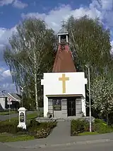
In the centre of Hlubočany is the Chapel of Saint Florian. It was built in 1935 on the site of an older Baroque chapel.[2] A small chapel is also in Terešov.
References
- "Population of Municipalities – 1 January 2023". Czech Statistical Office. 2023-05-23.
- "Vítejte" (in Czech). Obec Hlubočany. Retrieved 2024-04-11.
- "S památníkem německým starousedlíkům si Vyškov zatím neví rady" (in Czech). iDNES.cz. 2012-03-05. Retrieved 2022-01-12.
- "Historický lexikon obcí České republiky 1869–2011 – Okres Vyškov" (in Czech). Czech Statistical Office. 2015-12-21. pp. 1–2.
- "Population Census 2021: Population by sex". Public Database. Czech Statistical Office. 2021-03-27.
- "Výsledky vyhledávání: Kulturní památky, obec Hlubočany". Ústřední seznam kulturních památek (in Czech). National Heritage Institute. Retrieved 2024-04-11.