Kaliaganj
Kaliaganj, also spelled as Kaliyaganj, is a town and a municipality in Uttar Dinajpur district in the Indian state of West Bengal.[2] Kaliyaganj is a growing business and commerce region in North Dinajpur district, with rapid urbanisation and improved roadways.
Kaliaganj
Kaliyaganj | |
|---|---|
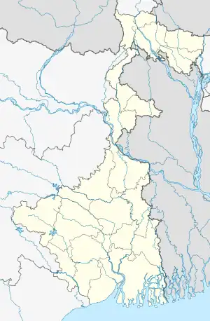 Kaliaganj Location in West Bengal, India  Kaliaganj Kaliaganj (India) | |
| Coordinates: 25.63°N 88.32°E | |
| Country | |
| State | West Bengal |
| District | Uttar Dinajpur |
| Government | |
| • Type | Municipality |
| • Body | Kaliaganj Municipality |
| • Chairman | Ram Niwas Saha (TMC) |
| • MLA | Soumen Roy (TMC) |
| Area | |
| • Total | 11.67 km2 (4.51 sq mi) |
| Elevation | 40 m (130 ft) |
| Population (2011) | |
| • Total | 53,530 |
| • Density | 4,600/km2 (12,000/sq mi) |
| Languages | |
| • Official | Bengali, English |
| Time zone | UTC+5:30 (IST) |
| PIN | 733129 |
| Telephone code | 03523 |
| Lok Sabha constituency | Raiganj |
| Vidhan Sabha constituency | Kaliaganj |
| Website | uttardinajpur |
Etymology
The word "Kaliyaganj" is come from the word "Kaliya" means "Krishna", the character of Mahabharata.
Geography
10miles
Bengal
Wildlife Sanctuary
checkpoint
Katabari
M: municipal city/ town, CT: census town, R: rural/ urban centre, T: tourist centre
Owing to space constraints in the small map, the actual locations in a larger map may vary slightly
Demographics
As per the 2011 Census of India, Kaliaganj had a total population of 53,530, of which 27,321 (51%) were males and 26,209 (49%) were females. Population below 6 years was 5,105. The total number of literates in Kaliaganj was 41,622 (85.95% of the population over 6 years).[7]
Transport
Kaliaganj has a station on the Barsoi-Radhikapur branch line.[8]
New broad gauge line from Kaliaganj to Buniadpur (33.10 km) was included in the budget 2010-11. 157.938 ha of land is to be acquired. As of August 2018, project work by Northeast Frontier Railway is held up mainly because of paucity of funds.[9]
State Highway No. 10A, running from Buniadpur to Raiganj passes through Kaliaganj town.[10]
Economy
Economy of Kaliaganj depends greatly on agriculture. There is no heavy industry in Kaliaganj, although there are some smaller ones.
Vivekananda More (Vivekananda Lane) is the main commercial, shopping and business hub of Kaliagnj. It is located directly near the Kaliyaganj Railway Station as well as the Kaliyaganj bus terminus. It is also located close to Tara Bazar, one of the two main agricultural markets in Kaliyaganj. The significance of Vivekananda More in Kaliaganj is similar to that of Police Bazar in the city of Shillong.
Education
- Kaliyaganj College was established in 1968. Affiliated to the University of Gour Banga, it offers honours courses in Bengali, English, Hindi, Sanskrit, political science, history, philosophy, economics, physics, chemistry, mathematics, computer science and accounting, and general courses in arts, science and commerce.[11][12]
- Kaliyaganj College of Education at Krishnabati, Kaliyaganj, offers B.Ed. and D.El.Ed. courses.[13]
- Kaliyaganj Parbati Sundari High School is a co-educational higher secondary school at Schoolpara, Kaliyaganj. Established in 1931, it has arrangements for teaching from class V to XII.[14][15]
- Kaliyaganj Milanmayee Girls’ High School is a girls only higher secondary school at Schoolpara, Kaliyaganj. Established in 1949, it has arrangements for teaching from class VI to XII.[16]
- Kaliyaganj Sarala Sundari High School.[17]
- Kaliyaganj Manomohan Girls' High School is a girls' school situated at Roy Colony, Kaliyaganj. It is a higher secondary school and was established by Shri Makhanlal Saha in 1968.
- Puria Maheshpur High School.
- Dalimgaon High school (H.S.)
Healthcare
Kaliaganj State General Hospital, with 60 beds is a major medical facility at Kaliaganj.[18]
Tourist spots
- Vivekananda More (Vivekananda Lane)
- Loknath Mandir
- Radhikapur
Notable people
- Priya Ranjan Dasmunsi - Former Union Minister, Government of India.
- Pramatha Nath Ray - Former Cabinet Minister in First Mamata Banerjee ministry, Government of West Bengal.
References
- "Kaliyaganj City".
- "Uttar Dinajpur Rail Network Map". Maps of India. Retrieved 2 February 2008.
- "District Statistical Handbook 2013 Uttar Dinajpur". Table 2.1. Department of Statistics and Programme Implementation, Government of West Bengal. Retrieved 5 January 2019.
- "Uttar Dinajpur District Police". Kaliyaganj Police Station. District Police. Retrieved 5 January 2019.
- "District Census Handbook Uttar Dinajpur, Series 20, Part XII A" (PDF). Map of Uttar Dinajpur district on the fifth page. Directorate of Census Operations, West Bengal. Retrieved 5 January 2019.
- "BDO Offices under Uttar Dinajpur District". Department of Mass Education Extension & Library Services, Government of West Bengal. West Bengal Public Library Network. Archived from the original on 19 January 2019. Retrieved 5 January 2019.
- "2011 Census – Primary Census Abstract Data Tables". West Bengal – District-wise. Registrar General and Census Commissioner, India. Retrieved 6 January 2019.
- "55729 Katihar-Radhikapur Passenger". Time Table. indiarailinfo. Retrieved 2 January 2019.
- "Brief of all projects (as of 31st August 2018)" (PDF). Page 15: New BG line from Kaliaganj to Buniadpur (33.10 Km). Northeast Frontier Railway (Cconstruction). Archived from the original (PDF) on 2 December 2018. Retrieved 2 December 2018.
- "List of State Highways in West Bengal". West Bengal Traffic Police. Retrieved 2 January 2019.
- "Kaliyaganj College". KC. Retrieved 7 January 2019.
- "Kaliyaganj College". College Admission. Retrieved 7 January 2019.
- "Kaliyaganj College of Education". KCE. Retrieved 7 January 2019.
- "Kaliyaganj Parbati Sundari High School". Target Study. Retrieved 7 January 2019.
- "Kaliyaganj Parbati Sundari High School". Free Tutorial.in. Retrieved 7 January 2019.
- "Kaliaganj Milanmayee Girls' High School". KMGHS. Retrieved 7 January 2019.
- Kaliyaganj Sarala Sundari High School, Pabna colony, Mahadebpur, Kaliyaganj, West Bengal 733129, Established in 1961, it has arrangements for teaching from class V to XII.
- "Health & Family Welfare Department". Health Statistics. Government of West Bengal. Retrieved 12 January 2019.
Cities, towns and locations in Uttar Dinajpur district, Malda division | ||||||
|---|---|---|---|---|---|---|
| Cities, municipal and census towns |
| 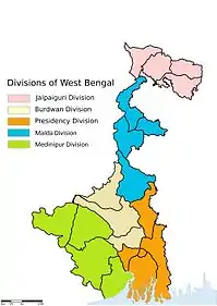 Divisions of West Bengal | ||||
| Locations other than cities and towns |
| |||||
| Neighbourhoods in Uttar Dinajpur |
| |||||
| Related topics | ||||||
| ||||||