Krumovgrad
Krumovgrad (Bulgarian: Крумовград [ˈkrumovˌɡrat], Turkish: Koşukavak [koˈʃukavak]) is a town in Kardzhali Province in the south of Bulgaria, located in the Eastern Rhodopes on the banks of the river Krumovitsa. The population is ethnic Muslims and ethnic Bulgarians.[1] The town is named after the successful medieval Bulgarian ruler Krum, the name meaning 'city of Krum' in Bulgarian.
Krumovgrad
Крумовград | |
|---|---|
 Centre of Krumovgrad | |
 Flag  Coat of arms | |
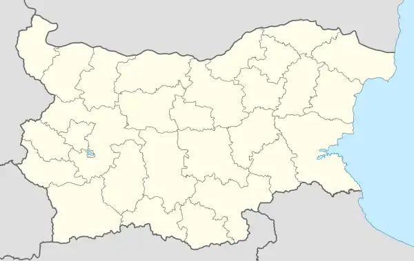 Krumovgrad Location of Krumovgrad | |
| Coordinates: 41°28′N 25°39′E | |
| Country | Bulgaria |
| Province (Oblast) | Kardzhali |
| Government | |
| • Mayor | Sebihan Mehmed |
| Elevation | 209 m (686 ft) |
| Population (13.09.2005) | |
| • Total | 8,690 |
| Time zone | UTC+2 (EET) |
| • Summer (DST) | UTC+3 (EEST) |
| Postal Code | 6900 |
| Area code | 03641 |
| Website | krumovgrad |
Municipality
Krumovgrad is also the seat of Krumovgrad municipality (part of Kardzhali Province), which includes the following 78 villages:
| Climate data for Krumovgrad 1991-2023,records(1926-2024) | |||||||||||||
|---|---|---|---|---|---|---|---|---|---|---|---|---|---|
| Month | Jan | Feb | Mar | Apr | May | Jun | Jul | Aug | Sep | Oct | Nov | Dec | Year |
| Record high °F (°C) | 70.3 (21.3) |
74.7 (23.7) |
83.8 (28.8) |
91.4 (33.0) |
98.2 (36.8) |
101.7 (38.7) |
109.9 (43.3) |
109.8 (43.2) |
104.0 (40.0) |
97.0 (36.1) |
86.0 (30.0) |
74.1 (23.4) |
109.9 (43.3) |
| Mean daily maximum °F (°C) | 44.6 (7.0) |
49.3 (9.6) |
56.3 (13.5) |
65.8 (18.8) |
74.8 (23.8) |
83.3 (28.5) |
88.3 (31.3) |
89.6 (32.0) |
80.8 (27.1) |
69.1 (20.6) |
57.6 (14.2) |
47.5 (8.6) |
67.3 (19.6) |
| Daily mean °F (°C) | 37.0 (2.8) |
40.1 (4.5) |
46.4 (8.0) |
54.7 (12.6) |
63.5 (17.5) |
71.4 (21.9) |
76.1 (24.5) |
76.5 (24.7) |
68.0 (20.0) |
57.9 (14.4) |
48.6 (9.2) |
39.7 (4.3) |
56.7 (13.7) |
| Mean daily minimum °F (°C) | 31.1 (−0.5) |
32.9 (0.5) |
38.3 (3.5) |
45.0 (7.2) |
53.6 (12.0) |
60.8 (16.0) |
64.4 (18.0) |
64.6 (18.1) |
56.8 (13.8) |
49.5 (9.7) |
41.5 (5.3) |
33.8 (1.0) |
47.7 (8.7) |
| Record low °F (°C) | −8.0 (−22.2) |
−7.6 (−22.0) |
6.1 (−14.4) |
22.3 (−5.4) |
35.2 (1.8) |
41.0 (5.0) |
46.4 (8.0) |
46.0 (7.8) |
33.3 (0.7) |
23.5 (−4.7) |
15.3 (−9.3) |
0.7 (−17.4) |
−8.0 (−22.2) |
| Average precipitation inches (mm) | 3.08 (78.3) |
2.96 (75.1) |
2.84 (72.2) |
2.30 (58.4) |
2.22 (56.4) |
2.07 (52.6) |
1.33 (33.7) |
0.77 (19.5) |
1.62 (41.1) |
2.73 (69.4) |
3.15 (80.0) |
4.15 (105.3) |
29.21 (742.0) |
| Average precipitation days | 9.6 | 8.8 | 8.5 | 8.1 | 9.5 | 9.0 | 3.8 | 2.9 | 4.0 | 9.0 | 9.7 | 10.5 | 93.4 |
| Average relative humidity (%) | 80 | 76 | 74 | 69 | 69 | 65 | 59 | 58 | 65 | 75 | 80 | 81 | 71 |
| Mean monthly sunshine hours | 93 | 118 | 168 | 201 | 261 | 303 | 338 | 331 | 235 | 167 | 115 | 79 | 2,490 |
| Source: http://climatebase.ru/station/15730/?lang=en | |||||||||||||
|
|
References
- Population of provinces, municipalities and settlements by ethnicity Archived 2016-03-03 at the Wayback Machine(in Bulgarian)
- "Archived copy" (PDF). Archived from the original (PDF) on March 9, 2012. Retrieved April 18, 2012.
{{cite web}}: CS1 maint: archived copy as title (link)
External links
This article is issued from Wikipedia. The text is licensed under Creative Commons - Attribution - Sharealike. Additional terms may apply for the media files.