Le Puid
Le Puid (French pronunciation: [lə pɥi] ⓘ) is a commune in the Vosges department in Grand Est in northeastern France.
Le Puid | |
|---|---|
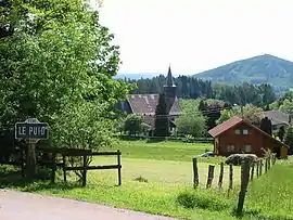 The church and surroundings in Le Puid | |
Location of Le Puid | |
 Le Puid 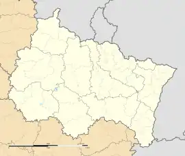 Le Puid | |
| Coordinates: 48°23′37″N 7°02′28″E | |
| Country | France |
| Region | Grand Est |
| Department | Vosges |
| Arrondissement | Saint-Dié-des-Vosges |
| Canton | Raon-l'Étape |
| Intercommunality | CA Saint-Dié-des-Vosges |
| Government | |
| • Mayor (2020–2026) | Régine Thomas Chinouilh[1] |
| Area 1 | 5.41 km2 (2.09 sq mi) |
| Population (2021)[2] | 115 |
| • Density | 21/km2 (55/sq mi) |
| Time zone | UTC+01:00 (CET) |
| • Summer (DST) | UTC+02:00 (CEST) |
| INSEE/Postal code | 88362 /88210 |
| Elevation | 400–643 m (1,312–2,110 ft) |
| 1 French Land Register data, which excludes lakes, ponds, glaciers > 1 km2 (0.386 sq mi or 247 acres) and river estuaries. | |
Inhabitants are called Piedestains.
History
Until 1793 Le Puid was part of the Principality of Salm-Salm.
See also
References
- "Répertoire national des élus: les maires". data.gouv.fr, Plateforme ouverte des données publiques françaises (in French). 9 August 2021.
- "Populations légales 2021". The National Institute of Statistics and Economic Studies. 28 December 2023.
Wikimedia Commons has media related to Le Puid.
This article is issued from Wikipedia. The text is licensed under Creative Commons - Attribution - Sharealike. Additional terms may apply for the media files.