M1 motorway (Hungary)
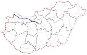
The M1 motorway (Hungarian: M1-es autópálya) is a toll motorway in northwestern Hungary, connecting Budapest to Győr and Vienna. The first section of the motorway opened in the 1970s, reaching the Austrian border at Hegyeshalom in 1996. It follows the route of the old Route 1 one-lane highway.
_Otszogletu_kek_tabla.svg.png.webp) | |
|---|---|
| M1-es autópálya | |
 | |
| Route information | |
| Part of | |
| Length | 171 km (106 mi) |
| Existed | 1964–present |
| History | Completed: 1996 |
| Major junctions | |
| From | Budapest |
| To | Hegyeshalom |
| Location | |
| Country | Hungary |
| Counties | Pest, Fejér, Komárom-Esztergom, Győr-Moson-Sopron |
| Major cities | Budapest, Tatabánya, Tata, Győr, Mosonmagyaróvár |
| Highway system | |
| |
Openings timeline
- Budapest – Budaörs (7 and 12 km): 1964 - half profile; (this section was extended 2x3 lane in 1978-79)
- Budaörs – Budakeszi (4 km): 1981 - half profile; (this section was extended in 1986)
- Budakeszi – Zsámbék (9 km): 1986
- Zsámbék – Bicske (13 km): 1985
- Bicske – Tatabánya-north (28 km): 1982
- Tatabánya-north – Komárom (20 km): 1975 - half profile; (this section was extended 2x2 lane in 1990)
- Komárom – Győr-east (19 km): 1977 - half profile; (this section was extended 2x2 lane in 1990)
- Győr-east – Győr-Ménfőcsanak (8 km): 1994
- Győr-Ménfőcsanak – Győr-west (14 km): 1994
- Győr-west – Hegyeshalom-east (42 km): 1996
- Hegyeshalom-east – Border station of Austria
 (6 km): 1982[1] - half profile; this section operated as part of road 1 until 1996
List of junctions, exits and rest area
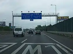
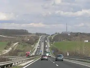
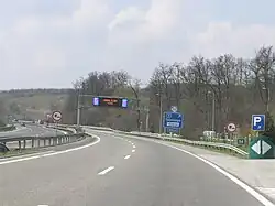
- The route is full length motorway. The maximum speed limit is 130km/h, with
 (2x2 lane road with stop lane).
Distance from Zero Kilometre Stone (Adam Clark Square) in Budapest in kilometres.
| km | Exit | Name | Destination | Notes | |
|---|---|---|---|---|---|
| 6 | Budapest, Budaörsi út | Connection to the center of Budapest, via Budaörsi út. The eastern terminus of the motorway. The eastern side of commons section as M1-M7 motorway. | |||
| 7 | Budaörs | ||||
| 9 | Drive only towards Budapest. Shopping centers | ||||
| 10 | Törökbálint Depo, Budaörs |
Eastern connection to Budaörs via Garibaldi utca. | |||
| Budaörsi pihenőhely | Rest area: | ||||
| 11 | Budaörs-nyugat | Western connection of Budaörs and Shopping centers. | |||
| 12 | M1-M7 intersection | Connection to M7 motorway towards to The western side of commons section as M1-M7 motorway. | |||
| 14 | Törökbálint, Budakeszi |
||||
| 15 | Tópark | Premier Outlet Center | |||
| 16 | M1-M0 interchange | Connection to Budapest bypass. The eastern terminus of European routes E60/E75 concurrency. | |||
| 17 | Biatorbágy |
Drive only towards Budapest. Eastern part Biatorbágy. | |||
| 22 | Sasfészek-tó pihenőhely | Rest area: | |||
| Biatorbágy, Páty | Western part of Biatorbágy and Business park. | ||||
| 27 | Zsámbék, Herceghalom |
Connection to Pilisjászfalu | |||
| 28 | Zsámbéki pihenőhely | Rest area: | |||
| 39 | Óbarok-Nagyegyháza, Bicske |
||||
| 43 | Óbarok pihenőhely | Rest area: | |||
| Not marked with a traffic sign | |||||
| Szárliget Bicske M1 Ipari Park |
|||||
| 54 | Harkályos pihenőhely | Rest area: | |||
| 56 | Tatabánya-Óváros | Connection to Óváros part of Tatabánya | |||
| 57 | Turul pihenőhely | Rest area: | |||
| 61 | Tatabánya-Centrum | Connection to Downtown of Tatabánya | |||
| 64 | Remeteségi pihenőhely | Rest area: | |||
| Tata-Remeteségpuszta | Not marked with a traffic sign | ||||
| 67 | Tata, Környe |
Connection to Csákvár | |||
| 72 | Grébics pihenőhely | Rest area: | |||
| 83 | Igmánd pihenőhely | Rest area: | |||
| 85 | Komárom, Kisbér | ||||
| 94 | Ács, Bana, Bábolna |
||||
| Concó pihenőhely | Rest area: | ||||
| 101 | Nagyszentjános, Bőny |
||||
| 107 | Győr-kelet | Access route of Győr. Eastern connection to the city | |||
| 112 | Győrszentiván | Eastern bypass to Győr, towards Vámosszabadi and Audi factory. | |||
| 115 | Győr-iparterület | Industrial area of Győr. | |||
| 119 | Győr-Szabadhegy | Szabadhegy district of Győr and Pannonhalma, Veszprém. | |||
| Arrabona pihenőhely | Rest area: | ||||
| 123 | Győr-Ménfőcsanak | Connection to Ménfőcsanak district of Győr and Pápa | |||
| Rába (Bridge - 355 m) | |||||
| 129 | Győr, Csorna |
Western connection to Szeged, towards to | |||
| 135 | Börcs pihenő | Rest area: | |||
| 142 | Lébény, Mecsér |
||||
| 144 | Lébény pihenő | Rest area: | |||
| 150 | Hanság pihenő | Rest area: | |||
| 158 | Lajta pihenőhely | Rest area: | |||
| 160 | Mosonmagyaróvár, Szombathely |
The eastern terminus of European routes E65 | |||
| 162 | Mosoni pihenőhely | Rest area: | |||
| 166 | M1-M15 interchange | Connection to M15 motorway, towards to Bratislava, The western terminus of European routes E65/E75 | |||
| 168 | Hegyeshalom-kelet | Eastern connection to Hegyeshalom. | |||
| 171 | Hegyeshalom | ||||
| 172 | Hegyeshalom border crossing | Connection to border crossing to Austria as the A4 motorway towards Vienna. The western terminus of the motorway and of the European route E60 concurrency. | |||
1.000 mi = 1.609 km; 1.000 km = 0.621 mi
| |||||
Maintenance
The operation and maintenance of the road by Hungarian Public Road Nonprofit Pte Ltd Co. This activity is provided by these highway engineers.
Payment
Hungarian system has 2 main type in terms of salary:
1, time-based fee vignettes (E-matrica); with a validity of either 10 days (3500 HUF), 1 month (4780 HUF) or 1 year (42980 HUF).[2]
2, county vignettes (Megyei matrica); the highway can be used instead of the national sticker with the following county stickers:
Type of county vignette Available section Pest County between Egér Street junction and Bicske (7 km – 39 km) Fejér County between Herceghalom and Tatabánya-Óváros (27 km – 56 km) Komárom-Esztergom County between Bicske and Győrszentiván (39 km – 112 km) Győr-Moson-Sopron County between Bábolna and Hegyeshalom [state border] (94 km – 172 km)
Toll-free section
- From Border of Budapest to Egér Street section (5 km – 7 km) can be used free of charge.
European Route(s)
| Name | Route | |
| 155 km | ||
| 150 km | ||
| 6 km | ||
See also
- Roads in Hungary
- Transport in Hungary
- International E-road network
References
- "A hegyeshalmi határátkelő". 14 May 2018.
- "National Toll Payment Services PLC". toll-charge.hu.
External links
- National Toll Payment Services Plc. (in Hungarian, some information also in English)
- Hungarian Public Road Non-Profit Ltd. (Magyar Közút Nonprofit Zrt.)
- National Infrastructure Developer Ltd.
