Mansfeld-Südharz
Mansfeld-Südharz is a district in Saxony-Anhalt, Germany. Its area is 1,449.1 km2 (559.5 sq mi).[2]
Mansfeld-Südharz | |
|---|---|
 Flag 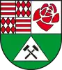 Coat of arms | |
| Country | Germany |
| State | Saxony-Anhalt |
| Capital | Sangerhausen |
| Government | |
| • District admin. | André Schröder (CDU) |
| Area | |
| • Total | 1,449.1 km2 (559.5 sq mi) |
| Population (31 December 2022)[1] | |
| • Total | 132,034 |
| • Density | 91/km2 (240/sq mi) |
| Time zone | UTC+01:00 (CET) |
| • Summer (DST) | UTC+02:00 (CEST) |
| Vehicle registration | MSH, EIL, HET, ML, SGH |
| Website | mansfeldsuedharz.de |
History
The district was established by merging the former districts of Sangerhausen and Mansfelder Land as part of the reform of 2007. In the German parliament, the Bundestag, the area forms part of the Mansfeld electoral district.
Towns and municipalities
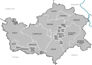
Clickable map of towns and municipalities in the district
The district Mansfeld-Südharz consists of the following subdivisions:[3]
| Free towns | Free municipalities |
|---|---|
|
|
| Verbandsgemeinden | ||
|---|---|---|
|
| |
| 1seat of the Verbandsgemeinde; 2town; | ||
References
Wikimedia Commons has media related to Landkreis Mansfeld-Südharz.
- "Bevölkerung der Gemeinden – Stand: 31. Dezember 2022" (PDF) (in German). Statistisches Landesamt Sachsen-Anhalt. June 2023.
- "Tabellen Bodenfläche". Statistisches Landesamt Sachsen-Anhalt. Retrieved 20 November 2022.
- "Statistisches Landesamt Sachsen-Anhalt". Archived from the original on 2017-05-15. Retrieved 2009-08-06.
| Urban districts | |
|---|---|
| Rural districts | |
| Former districts | |
This article is issued from Wikipedia. The text is licensed under Creative Commons - Attribution - Sharealike. Additional terms may apply for the media files.