Martí, Cuba
Martí is a Cuban town and municipality in north-eastern section of Matanzas Province.
Martí | |
|---|---|
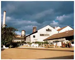 The old sugar refinery "Guipuzcúa" | |
 Coat of arms | |
.png.webp) Martí municipality (red) within Matanzas Province (yellow) and Cuba | |
| Coordinates: 22°57′8″N 80°55′0″W | |
| Country | Cuba |
| Province | Matanzas |
| Founded | 1835 (Hato Nuevo)[1] |
| Established | 1879 |
| Area | |
| • Total | 1,070 km2 (410 sq mi) |
| Elevation | 20 m (70 ft) |
| Population (2022)[3] | |
| • Total | 21,582 |
| • Density | 20/km2 (52/sq mi) |
| Time zone | UTC-5 (EST) |
| Area code | +53-56 |
Geography
The municipality is divided into the barrios of Guamutas, Lacret, La Teja, Martí, Motembo and Río de la Palma.[1] From 1902 until 1927 the village of Máximo Gómez (now part of Perico), was part of Martí.
It is located on the north-central coast of Cuba, and includes the lagoons Inglés, Bibanasí and Majagüillar, all extensions of the Bay of Santa Clara (Bahia de Santa Clara). Its territory is crossed by the rivers La Palma, Júcaro and San Manuel.
History
The town was founded in 1835 was established in 1835 under the name Hato Nuevo[1] on the location of the Bibanosí ranch. On 24 December 1898 the name was changed to Martí, in honour of independence hero José Martí.
Demographics
In 2022, the municipality of Martí had a population of 21,582.[3] With a total area of 1,070 km2 (410 sq mi),[2] it has a population density of 21.9/km2 (57/sq mi).
References
- Guije.com. "Martí" (in Spanish). Retrieved 2007-10-07.
- Statoids (July 2003). "Municipios of Cuba". Retrieved 2007-10-07.
- "Cuba: Administrative Division (Provinces and Municipalities) - Population Statistics, Charts and Map". www.citypopulation.de. Retrieved 2024-02-03.
External links
 Media related to Martí, Cuba at Wikimedia Commons
Places adjacent to Martí, Cuba | ||||||||||||||||
|---|---|---|---|---|---|---|---|---|---|---|---|---|---|---|---|---|
| ||||||||||||||||