Mount Cook National Park, Australia
Mount Cook National Park is a protected area in the locality of Cooktown, in the Shire of Cook, Queensland, Australia.[1]
| Mount Cook National Park Queensland | |
|---|---|
 | |
 Mount Cook National Park | |
| Nearest town or city | Cooktown |
| Coordinates | 15.491°S 145.260°E |
| Established | 1970 |
| Area | 5.02 km2 (1.94 sq mi) |
| Managing authorities | Queensland Parks and Wildlife Service |
| See also | Protected areas of Queensland |
Geography
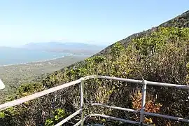
The national park is immediately south of the town of Cooktown.[2]
The terrain ranges from 0 to 431 metres (0 to 1,414 ft) above sea level.[2] The mountain Mount Cook is in the east of the national park (15.4906°S 145.2642°E). Also known as Gore Mount, it rises 431 metres (1,414 ft) above sea level, the highest point in the national park.[3][4]
It is 1,554 km (966 mi) north-west of Brisbane. It was established in 1970 and is managed by the Queensland Parks and Wildlife Service.
Within this National Park is a difficult walking track that is six kilometres (3.7 mi) return to the summit of Mount Cook.[5]
See also
- Protected areas of Queensland
References
- "Mount Cook National Park – national park in the Shire of Cook (entry 39564)". Queensland Place Names. Queensland Government. Retrieved 11 February 2024.
- "Queensland Globe". State of Queensland. Retrieved 11 February 2024.
- "Mount Cook – mountain in Cook Shire (entry 8044)". Queensland Place Names. Queensland Government. Retrieved 25 November 2020.
- "Mountain peaks and capes - Queensland". Queensland Open Data. Queensland Government. 12 November 2020. Archived from the original on 25 November 2020. Retrieved 25 November 2020.
- "About Mount Cook". Archived from the original on 9 April 2019. Retrieved 6 January 2020.
This article is issued from Wikipedia. The text is licensed under Creative Commons - Attribution - Sharealike. Additional terms may apply for the media files.