Nagpur division
The Nagpur Division is one of six administrative divisions of the state of Maharashtra in India. Nagpur is the easternmost division in the state, with an administrative headquarters in the city of Nagpur. It covers 51,336 km² (19,821 mi²). The Amravati and Nagpur divisions make up the Vidarbha region.
Nagpur Division | |
|---|---|
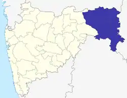 Location of Nagpur Division in Maharashtra | |
| Coordinates: 21°09′36″N 79°04′48″E | |
| Country | India |
| State | Maharashtra |
| Districts | 1. Bhandara, 2. Chandrapur, 3. Gadchiroli, 4. Gondia, 5. Nagpur, 6. Wardha |
| Government | |
| • Commissioner Nagpur Division | Vijayalakshmi Bidari IAS |
| • Police Commissioner Nagpur Division | NA |
| • All Guardian Minister Nagpur Division |
|
| • All District Collector's Nagpur Division |
|
| • All MP's Nagpur Division | NA |
| Area | |
| • Total | 51,336 km2 (19,821 sq mi) |
| • Under irrigation | 4,820 km2 (1,860 sq mi) |
| Population (2011) | |
| • Total | 11,754,434 |
Two airports, Dr. Babasaheb Ambedkar International Airport and Gondia Airport, are located here.
History
Nagpur Division was created in 1861, when the Central Provinces administrative division of British India was created by merging the Nagpur Province and the Saugor and Nerbudda Territories. Before 1861, Nagpur Division had been part of Nagpur Province, which had been created after the Nagpur kingdom was annexed by the British in 1853 by means of the Doctrine of lapse.[1] The British Nagpur Division included the current districts as well as Balaghat District, currently part of Madhya Pradesh.[2]
After Indian Independence, The Central Provinces and Berar (Nagpur and Amravati divisions) became the new state of Madhya Pradesh. The Indian states were reorganised along linguistic lines in 1956, and on 1 November, Nagpur and Amravati divisions were transferred to Bombay State, while Balaghat District remained in Madhya Pradesh. The Marathi-speaking portion of Bombay State became Maharashtra in 1960.
Demographics
As per the 2011 Census of India, Amravati Division had a population of 11,258,117 in the year 2011.[3]
Languages
Marathi is the most spoken language, which is also the sole official language of the region. There are significant minorities of Hindi speakers and speakers of tribal languages in Nagpur Division.
Religion
At the time of the 2011 Census of India, 80.14% of the population of Nagpur Division followed Hinduism, 12.70% Buddhism, 5.19% Islam, 0.47% Christianity and the remaining 1.50% of the population followed other religions or stated no religion.[3]
Religion in Nagpur Division (2011)[3]
Administration, Districts, and Talukas
Nagpur Division has 6 districts. Following table shows the districts of Nagpur Division and their talukas:
| Name of Division (Headquarter) | Sr. No. | Districts | Administration | Sub-Division | Taluka | Source |
|---|---|---|---|---|---|---|
| Nagpur Division HQ=Nagpur Districts=6 SubDivisions=31 Talukas=64 |
1. | Bhandara district | HQ-Bhandara Sub-Divisions-3 Taluka-7 |
Bhandara |
|
District website |
| Tumsar |
| |||||
| Sakoli |
| |||||
| 2. | Chandrapur District | HQ-Chandrapur Sub-Divisions-8 Taluka-15 |
Chandrapur | District website | ||
| Ballarpur | ||||||
| Mul |
| |||||
| Gondpimpri |
| |||||
| Warora | ||||||
| Chimur |
| |||||
| Rajura |
| |||||
| Bramhapuri |
| |||||
| 3. | Gadchiroli District | HQ-Gadchiroli Sub-Divisions-6 Taluka-12 |
Gadchiroli |
|
District website | |
| Chamorshi |
| |||||
| Aheri |
| |||||
| Etapalli |
| |||||
| Desaiganj/(Wadasa) |
| |||||
| Kurkheda |
| |||||
| 4. | Gondia District | HQ-Gondia Sub-Divisions-4 Taluka-8 |
Gondia | District website | ||
| Tiroda |
| |||||
| Deori |
| |||||
| Arjuni Morgaon |
| |||||
| 5. | Nagpur District | HQ-Nagpur Sub-Divisions-7 Taluka-14 |
Nagpur City | District website | ||
| Nagpur Rural |
| |||||
| Mauda |
| |||||
| Umred |
| |||||
| Ramtek |
| |||||
| Saoner |
| |||||
| Katol |
| |||||
| 6. | Wardha District | HQ-Wardha Sub-Divisions-3 Taluka-8 |
Wardha |
|
District website | |
| Arvi |
| |||||
| Hinganghat |
| |||||
| Total Districts = 6 | Total Sub-Divisions = 31 | Total Talukas = 64 | ||||
References
- "History; Gazetteer, 1966". Archived from the original on 3 March 2016. Retrieved 24 June 2014.
- Hunter, William Wilson, Sir, et al. (1908). Imperial Gazetteer of India, 1908-1931; Clarendon Press, Oxford
- "Population By Religious Community" (XLS). censusindia.gov.in. Retrieved 17 September 2023.
| Topics | |||||||||||||
|---|---|---|---|---|---|---|---|---|---|---|---|---|---|
| Regions |
| ||||||||||||
| Divisions and Districts |
| ||||||||||||
| Million-plus cities in Maharashtra | |||||||||||||
| Other cities with municipal corporations | |||||||||||||
| Government | |||||||||||||
Portal:India | |||||||||||||