Percey
Percey (French pronunciation: [pɛʁsɛ]) is a commune in the Yonne department in Bourgogne-Franche-Comté in north-central France.
Percey | |
|---|---|
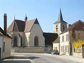 The church in Percey | |
.svg.png.webp) Coat of arms | |
Location of Percey | |
 Percey 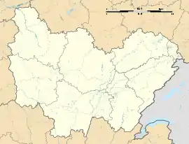 Percey | |
| Coordinates: 47°57′52″N 3°49′34″E | |
| Country | France |
| Region | Bourgogne-Franche-Comté |
| Department | Yonne |
| Arrondissement | Auxerre |
| Canton | Saint-Florentin |
| Government | |
| • Mayor (2020–2026) | Daniel Boucheron[1] |
| Area 1 | 9.56 km2 (3.69 sq mi) |
| Population (2021)[2] | 248 |
| • Density | 26/km2 (67/sq mi) |
| Time zone | UTC+01:00 (CET) |
| • Summer (DST) | UTC+02:00 (CEST) |
| INSEE/Postal code | 89292 /89360 |
| Elevation | 109–155 m (358–509 ft) (avg. 135 m or 443 ft) |
| 1 French Land Register data, which excludes lakes, ponds, glaciers > 1 km2 (0.386 sq mi or 247 acres) and river estuaries. | |
It lies on the Canal de Bourgogne, with the Route départementale (D945), named locally «Rue Nationale» running through it, between Saint-Florentin and Tonnerre.
Percey is the main village of the commune of Percey. Other villages are: Les Milleries and La Sogne.
The Château de Percey and the farm, church and old coach-house still exist.
ADSL is available there (as of 2012 2Mbs maximum), and the Chateau hosts a free wireless hotspot, as does the town hall (since 2008).
See also
References
- "Répertoire national des élus: les maires" (in French). data.gouv.fr, Plateforme ouverte des données publiques françaises. 13 September 2022.
- "Populations légales 2021". The National Institute of Statistics and Economic Studies. 28 December 2023.
Wikimedia Commons has media related to Percey.
This article is issued from Wikipedia. The text is licensed under Creative Commons - Attribution - Sharealike. Additional terms may apply for the media files.