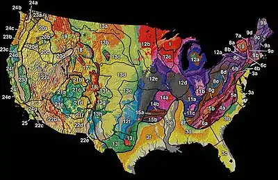
Physiographic regions of the United States
The physiographic regions of the contiguous United States comprise 8 divisions, 25 provinces, and 85 sections.[1] The system dates to Nevin Fenneman's report Physiographic Divisions of the United States, published in 1916.[2] [3] The map was updated and republished by the Association of American Geographers in 1928.[4] The map was adopted by the United States Geological Survey by publication in 1946. [5]

.jpg.webp)
The classification hierarchy used in the 1916 publication of the American Association of Geographers was division/province/section/subsection. The use of province in this hierarchy undoubtedly confounded the effort to develop a physiographical map consistent across the North American continent since Canada used province as the term for its first-level political subdivision. Province in Canada is a loose analogy for state in the US, and obviously would create great confusion if the same word was used in two vastly different geographical classifications. As late as 1914, the terminology used by an AAG publication used the term "natural region" as the basic denomination of physiography. [6] That work showed 22 examples of how geographers had published works classifying North America into what had been defined as natural regions. Most included all of North America without regard to political subdivision.
Fenneman expanded and presented a derivative of this system more fully in two books, Physiography of western United States (1931),[7] and Physiography of eastern United States (1938).[8]
Physiographic divisions
| Division | Province | Section |
|---|---|---|
| I. Laurentian Upland | 1. Superior Upland | |
| II. Atlantic Plain | 2. Continental Shelf (not on map) | |
| 3. Coastal Plain | 3a. Embayed section | |
| 3b. Sea Island section | ||
| 3c. Floridian section | ||
| 3d. East Gulf Coastal Plain | ||
| 3e. Mississippi Alluvial Plain | ||
| 3f. West Gulf Coastal Plain | ||
| III. Appalachian Highlands | 4. Piedmont | 4a. Piedmont Upland |
| 4b. Piedmont Lowlands | ||
| 5. Blue Ridge province | 5a. Northern section | |
| 5b. Southern section | ||
| 6. Valley and Ridge province | 6a. Tennessee section | |
| 6b. Middle section | ||
| 6c. Hudson Valley | ||
| 7. St. Lawrence Valley | 7a. Champlain section (dividing line undefined in 1946 map) | |
| 7b. Northern section (dividing line undefined in 1946 map) | ||
| 8. Appalachian Plateaus province | 8a. Mohawk section | |
| 8b. Catskill section | ||
| 8c. Southern New York section | ||
| 8d. Allegheny Plateau section | ||
| 8e. Kanawha section | ||
| 8f. Cumberland Plateau section | ||
| 8g. Cumberland Mountain section | ||
| 9. New England Province | 9a. Seaboard Lowland section | |
| 9b. New England Upland section | ||
| 9c. White Mountain section | ||
| 9d. Green Mountain section | ||
| 9e. Taconic section | ||
| 10. Adirondack province | ||
| IV. Interior Plains | 11. Interior Low Plateaus | 11a. Highland Rim |
| 11b. Lexington Plain | ||
| 11c. Nashville Basin | ||
| 12. Central Lowland | 12a. Eastern Lake | |
| 12b. Western Lake | ||
| 12c. Wisconsin Driftless | ||
| 12d. Till Plains | ||
| 12e. Dissected Till Plains | ||
| 12f. Osage Plains | ||
| 13. Great Plains | 13a. Missouri Plateau (glaciated) | |
| 13b. Missouri Plateau (unglaciated) | ||
| 13c. Black Hills | ||
| 13d. High Plains | ||
| 13e. Plains Border | ||
| 13f. Colorado Piedmont | ||
| 13g. Raton section | ||
| 13h. Pecos Valley | ||
| 13i. Edwards Plateau | ||
| 13j. Central Texas | ||
| V. Interior Highlands | 14. Ozark Plateaus | 14a. Springfield-Salem plateaus |
| 14b. Boston Mountains | ||
| 15. Ouachita province | 15a. Arkansas Valley | |
| 15b. Ouachita Mountains | ||
| VI. Rocky Mountain System | 16. Southern Rocky Mountains | |
| 17. Wyoming Basin | ||
| 18. Middle Rocky Mountains | ||
| 19. Northern Rocky Mountains | ||
| VII. Intermontane Plateaus | 20. Columbia Plateau | 20a. Walla Walla Plateau |
| 20b. Blue Mountain section | ||
| 20c. Payette section | ||
| 20d. Snake River Plain | ||
| 20e. Harney section | ||
| 21. Colorado Plateaus | 21a. High Plateaus of Utah | |
| 21b. Uinta Basin | ||
| 21c. Canyon Lands | ||
| 21d. Navajo section | ||
| 21e. Grand Canyon section | ||
| 21f. Datil section | ||
| 22. Basin and Range Province | 22a. Great Basin section | |
| 22b. Sonoran Desert | ||
| 22c. Salton Trough | ||
| 22d. Mexican Highland | ||
| 22e. Sacramento section | ||
| VIII. Pacific Mountains | 23. Cascade-Sierra Mountains | 23a. Northern Cascade Mountains |
| 23b. Middle Cascade Mountains | ||
| 23c. Southern Cascade Mountains | ||
| 23d. Sierra Nevada | ||
| 24. Pacific Border province | 24a. Puget Trough | |
| 24b. Olympic Mountains | ||
| 24c. Oregon Coast Range | ||
| 24d. Klamath Mountains | ||
| 24e. California Trough | ||
| 24f. California Coast Ranges | ||
| 24g. "Los Angeles Ranges—(Transverse Ranges)" | ||
| 25. Lower California province—(Peninsular Ranges) | ||
References
- "Physiographic Regions". United States Geological Survey. 2003-04-17. Archived from the original on 2006-05-15. Retrieved 2008-01-30.
- Fenneman, Nevin M. (1916). "Physiographic Divisions of the United States". Annals of the Association of American Geographers. 6 (1): 19–98. doi:10.1080/00045601609357047. hdl:2027/njp.32101059544153. ISSN 0004-5608.
- Fenneman, Nevin M. (1917). "Physiographic Subdivision of the United States". Proceedings of the National Academy of Sciences of the United States of America. 3 (1): 17–22. doi:10.1073/pnas.3.1.17. OCLC 43473694. PMC 1091163. PMID 16586678.
- Fenneman, Nevin M. (1928). "Physiographic Divisions of the United States". Annals of the Association of American Geographers. 18 (4): 261–353. doi:10.2307/2560726. hdl:2027/njp.32101059544153. JSTOR 2560726.
- Fenneman, Nevin M. (1946). Physical divisions of the United States (Report). U.S. Geological Survey. doi:10.3133/70207506.
- Joerg, Wolfgang L. G. (1914). "The Subdivision of North America into Natural Regions: A Preliminary Inquiry". Annals of the Association of American Geographers. 4: 55–83. doi:10.2307/2560741. JSTOR 2560741.
- Fenneman, Nevin Melancthon (1931). Physiography of western United States. McGraw-Hill. OCLC 487636.
- Fenneman, Nevin Melancthon (1938). Physiography of eastern United States. McGraw-Hill. OCLC 487628.