Pingxiang, Guangxi
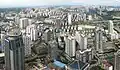
Pingxiang (凭祥市) is a county-level city under the administration of the prefecture-level city of Chongzuo, in the southwest of the Guangxi Zhuang Autonomous Region, China.
Pingxiang
凭祥市 · Bingzsiengz Si | |
|---|---|
.jpg.webp) | |
 Pingxiang Location in Guangxi | |
| Coordinates: 22°05′38″N 106°45′58″E | |
| Country | China |
| Province | Guangxi |
| Prefecture-level city | Chongzuo |
| Municipal seat | Pingxiang |
| Area | |
| • Total | 650 km2 (250 sq mi) |
| Population (2020) | |
| • Total | 129,843 |
| • Density | 200/km2 (520/sq mi) |
| Time zone | UTC+8 (China Standard) |
| Pingxiang, Guangxi | |||||||||||
|---|---|---|---|---|---|---|---|---|---|---|---|
| Chinese name | |||||||||||
| Simplified Chinese | 凭祥市 | ||||||||||
| Traditional Chinese | 憑祥市 | ||||||||||
| |||||||||||
| Vietnamese name | |||||||||||
| Vietnamese | Thị xã Bằng Tường / Bằng Tường thị | ||||||||||
| Hán-Nôm | 市社憑祥/憑祥市 | ||||||||||
| Zhuang name | |||||||||||
| Zhuang | Bingzsiengz Si | ||||||||||
| 1957 orthography | Biŋƨsieŋƨ Si | ||||||||||
Situation
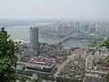
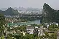
The city covers an area of 650 km2 (250 sq mi). It is bordered in the north by Longzhou County and in the east by Ningming County, both in Chongzuo, and in the south and west by Vietnam's Lạng Sơn Province.
National Route 322 comes through the city centre, as does the railway which continues on to Hanoi; a high-speed expressway, now also international, passes nearby.
Zhennan Pass, site of the Battle of Bang Bo during the Sino-French War, is now named the "Friendship Pass" and is considered the gateway to Vietnam.
There are also plans to build a high-speed railway from Nanning to the Vietnamese border.[1]
Demographics
Pingxiang has a population of approximately 106,400 (83.5% of the people belong to the Zhuang ethnic group, 2010).[2] Ethnic groups include Zhuang, Han, Yao, Miao, Jing, and others.
Administrative divisions
Pingxiang is divided into 4 towns:[3]
- Pingxiang (凭祥镇)
- Shangshi (上石镇)
- Xiashi (夏石镇)
- Youyi (友谊镇)
Transportation
Rail
- Hunan–Guangxi Railway
Climate
| Climate data for Pingxiang (1991–2014 normals, extremes 1981–2010) | |||||||||||||
|---|---|---|---|---|---|---|---|---|---|---|---|---|---|
| Month | Jan | Feb | Mar | Apr | May | Jun | Jul | Aug | Sep | Oct | Nov | Dec | Year |
| Record high °C (°F) | 30.2 (86.4) |
36.1 (97.0) |
35.4 (95.7) |
38.6 (101.5) |
40.0 (104.0) |
37.7 (99.9) |
37.8 (100.0) |
37.1 (98.8) |
36.7 (98.1) |
34.6 (94.3) |
33.4 (92.1) |
30.8 (87.4) |
40.0 (104.0) |
| Mean daily maximum °C (°F) | 17.6 (63.7) |
19.8 (67.6) |
22.3 (72.1) |
27.6 (81.7) |
31.1 (88.0) |
32.5 (90.5) |
32.8 (91.0) |
32.5 (90.5) |
31.3 (88.3) |
28.7 (83.7) |
24.9 (76.8) |
20.4 (68.7) |
26.8 (80.2) |
| Daily mean °C (°F) | 13.5 (56.3) |
15.8 (60.4) |
18.6 (65.5) |
23.2 (73.8) |
26.3 (79.3) |
27.8 (82.0) |
28.0 (82.4) |
27.4 (81.3) |
26.0 (78.8) |
23.2 (73.8) |
19.2 (66.6) |
15.1 (59.2) |
22.0 (71.6) |
| Mean daily minimum °C (°F) | 10.7 (51.3) |
13.0 (55.4) |
16.0 (60.8) |
20.2 (68.4) |
22.9 (73.2) |
24.6 (76.3) |
24.8 (76.6) |
24.3 (75.7) |
22.8 (73.0) |
19.8 (67.6) |
15.6 (60.1) |
11.7 (53.1) |
18.9 (66.0) |
| Record low °C (°F) | 1.2 (34.2) |
2.6 (36.7) |
3.3 (37.9) |
9.6 (49.3) |
14.1 (57.4) |
15.5 (59.9) |
19.1 (66.4) |
21.6 (70.9) |
15.5 (59.9) |
9.1 (48.4) |
3.5 (38.3) |
0.1 (32.2) |
0.1 (32.2) |
| Average precipitation mm (inches) | 33.9 (1.33) |
30.0 (1.18) |
57.7 (2.27) |
83.0 (3.27) |
156.0 (6.14) |
201.5 (7.93) |
223.4 (8.80) |
239.6 (9.43) |
132.9 (5.23) |
59.3 (2.33) |
44.2 (1.74) |
28.5 (1.12) |
1,290 (50.77) |
| Average precipitation days (≥ 0.1 mm) | 11.7 | 11.9 | 15.1 | 12.7 | 14.0 | 17.3 | 17.0 | 17.6 | 11.5 | 7.2 | 6.5 | 7.5 | 150 |
| Average relative humidity (%) | 80 | 82 | 82 | 80 | 78 | 80 | 80 | 82 | 81 | 80 | 79 | 77 | 80 |
| Mean monthly sunshine hours | 66.1 | 60.4 | 51.3 | 88.9 | 146.9 | 146.6 | 172.6 | 169.0 | 166.8 | 154.5 | 134.9 | 111.0 | 1,469 |
| Percent possible sunshine | 20 | 19 | 14 | 23 | 36 | 36 | 42 | 43 | 46 | 43 | 41 | 33 | 33 |
| Source: China Meteorological Administration[4][5] | |||||||||||||
See also
- Lang Son
Notes and references
- "High-speed railway to boost trade". Retrieved 2011-02-19.
- Main data bulletin of the sixth national census in 2010/Chongzuo Statistics Bureau Archived 2013-06-20 at the Wayback Machine, 2011-07-21(in Chinese)
- 2023年统计用区划代码和城乡划分代码:凭祥市 (in Simplified Chinese). National Bureau of Statistics of China.
- 中国气象数据网 – WeatherBk Data (in Simplified Chinese). China Meteorological Administration. Retrieved 28 May 2023.
- 中国气象数据网 (in Simplified Chinese). China Meteorological Administration. Retrieved 28 May 2023.
| |||||||||||||||||||||||||||||||||||||||||||||||||||||||||||||||||||||||||||