Sigi Regency
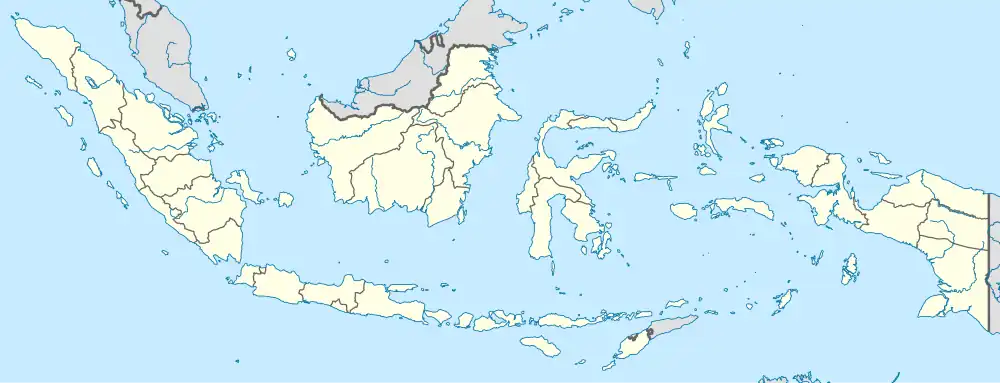
Sigi Regency is a regency of Central Sulawesi, Indonesia. It was created on 21 July 2008 by splitting off the southern districts from Donggala Regency. It lies upstream on the Palu River, and immediately south of Palu city, the provincial capital. It covers an area of 5,196.02 km2 and had a population of 215,030 at the 2010 Census[2] and 239,421 at the 2020 Census;[3] the official estimate as at mid 2023 was 266,656 (comprising 136,510 males and 130,140 females).[1] The principal town lies at Sigi Biromaru.
Sigi Regency
Kabupaten Sigi | |
|---|---|
 Coat of arms | |
| Motto(s): Mareso Masagena (Kaili) (Difficult and Happy to be Together) | |
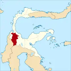 Location within Central Sulawesi | |
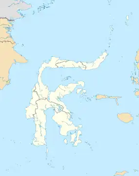
| Coordinates: 1°23′06″S 119°58′01″E | |
| Country | Indonesia |
| Province | Central Sulawesi |
| Capital | Sigi Biromaru |
| Government | |
| • Regent | Mohamad Irwan, S.Sos., M.Si |
| • Vice Regent | Dr. Samuel Yansen Pongi, SE., M.Si |
| Area | |
| • Total | 5,196.02 km2 (2,006.19 sq mi) |
| Population (mid 2023 estimate)[1] | |
| • Total | 266,656 |
| • Density | 51/km2 (130/sq mi) |
| Time zone | UTC+8 (ICST) |
| Area code | (+62) 451 |
| Website | sigikab.go.id |
Sigi Regency was one of the areas in northwest Sulawesi most affected by the 2018 earthquake and tsunami in Sulawesi. Dozens of people were reported to have been killed by the earthquake and there were reports of "massive liquification" which caused homes to be swept away.


Conflicts
Following religious conflicts in the neighbouring Poso Regency, the Indonesia government mounted Operation Tinombala in early 2016 to combat local terrorist activities carried out by the East Indonesia Mujahiddin (Mujahiddin Indonesian Timur, or MIT) in the province.[4] In late November 2020, there were indications that the conflict had spread into Sigi Regency when four residents of remote Lembantongoa village were killed in an apparent terrorist attack attributed to MIT.[5] Indonesia's senior Coordinating Political, Legal and Security Minister Mahfud MD issued a statement saying that the government was committed to tracking down those responsible for the murders and the accompanying destruction.
Administrative Districts
The Sigi Regency was divided at 2010 and at 2020 into fifteen districts (kecamatan), but on 14 September 2020 a sixteenth district (Sigi Kota) was formed from parts of Sigi Biromaru (7 desa), Dolo (2 desa) and Palolo (1 desa) Districts. The districts are tabulated below with their areas and their populations at the 2010 Census[2] and 2020 Census,[3] together with the official estimates as at mid 2023.[1] The table also includes the locations of the district administrative centres, and the numbers of villages (all rated as rural desa) in each district.
| Kode Wilayah | Name of District (kecamatan) | Area in km2 | Pop'n Census 2010 | Pop'n Census 2020 | Pop'n Estimate mid 2023 | Admin centre | No. of desa |
|---|---|---|---|---|---|---|---|
| 72.10.07 | Pipikoro | 956.13 | 7,817 | 8,720 | 8,615 | Peana | 19 |
| 72.10.06 | Kulawi Selatan (South Kulawi) | 418.12 | 8,473 | 9,440 | 9,772 | Lawua | 12 |
| 72.10.05 | Kulawi | 1,053.56 | 14,172 | 15,810 | 16,305 | Bolapopo | 16 |
| 72.10.04 | Lindu | 552.03 | 4,690 | 5,250 | 5,557 | Tomado | 5 |
| 72.10.03 | Nokilalaki | 75.19 | 5,626 | 6,260 | 5,731 | Kamarora | 5 |
| 72.10.02 | Palolo | 581.48 | 27,385 | 30,440 | 29,983 | Makmur | 21 |
| 73.10.08 | Gumbasa | 176.49 | 11,682 | 13,010 | 13,578 | Pakuli | 7 |
| 72.10.10 | Tanambulava | 56.33 | 7,866 | 8,770 | 9,895 | Sibalaya Utara | 5 |
| 72.10.09 | Dolo Selatan (South Dolo) | 584.71 | 14,448 | 16,080 | 17,284 | Baluase | 12 |
| 72.10.11 | Dolo Barat (West Dolo) | 112.18 | 12,576 | 14,010 | 15,183 | Kalele | 12 |
| 72.10.12 | Dolo | 21.79 | 20,591 | 22,930 | 23,206 | Kota Pulu | 9 |
| 72.10.01 | Sigi Biromaru | 175.29 | 42,857 | 47,710 | 48,775 | Mpanau | 10 |
| 72.10.14 | Marawola | 38.65 | 20,991 | 23,360 | 30,068 | Binangga | 11 |
| 72.10.15 | Marawola Barat (West Marawola) | 150.51 | 6,382 | 7,100 | 5,789 | Dombu | 12 |
| 72.10.13 | Kinovaro | 70.38 | 9,474 | 10,540 | 10,794 | Porame | 10 |
| 72.10.16 | Sigi Kota (Sigi Town) | 173.10 | (a) | (a) | 16,121 | Bora | 10 |
| Totals | 5,196.02 | 215,030 | 239,421 | 266,656 | Sigi Biromaru | 177 |
Note (a) the population of the new Sigi Kota District in 2010 and 2020 is included in the figures for Sigi Biromaru, Dolo and Palolo Districts, from parts of which it was created on 14 September 2020.
References
- Badan Pusat Statistik, Jakarta, 28 February 2024, Kabupaten Sigi Dalam Angka 2024 (Katalog-BPS 1102001.7210)
- Biro Pusat Statistik, Jakarta, 2011.
- Badan Pusat Statistik, Jakarta, 2021.
- Marchio Irfan Gorbiano, 'Reevaluate Operation Tinambala after Sigi attack: Analysts', The Jakarta Post, 9 December 2020.
- Any Rufaedah and Idhamsyah Eka Putra, 'IS replication in Indonesia and counterterrism after the Sigi attack', East Asia Forum, Australian National University, 9 January 2012. See also Rizki Rachriansyah, 'Four killed in alleged MIT attack in Sigi, reigniting concerns over sectarian conflict', The Jakarta Post, 29 November 2020.
Regencies and cities of Central Sulawesi | ||
|---|---|---|
Capital: Palu | ||
| Regencies |
| |
| Cities | ||