South Sorong Regency
South Sorong Regency (Indonesian: Sorong Selatan) is a regency of Southwest Papua province of Indonesia. It has an area of 6,570.23 km2, and had a population of 37,900 at the 2010 Census[2] and 52,469 at the 2020 Census;[3] the official estimate as at mid 2023 was 54,277 (comprising 27,833 males and 26,444 females).[1] The administrative centre is the town of Teminabuan.
South Sorong Regency
Kabupaten Sorong Selatan | |
|---|---|
 Seal | |
 Location in Southwest Papua | |
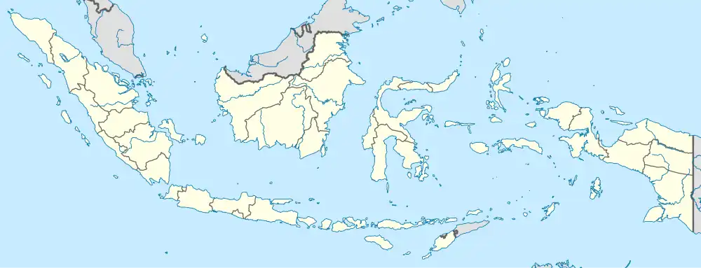 South Sorong Regency Location in Indonesia | |
| Coordinates: 1.5050°S 132.2864°E | |
| Country | |
| Province | Southwest Papua |
| Capital | Teminabuan |
| Government | |
| • Regent | Samsudin Anggiluli |
| • Vice Regent | Marthinus Salamuk |
| Area | |
| • Total | 6,570.23 km2 (2,536.78 sq mi) |
| Population (mid 2023 estimate)[1] | |
| • Total | 54,277 |
| • Density | 8.3/km2 (21/sq mi) |
| Time zone | UTC+9 (Indonesia Eastern Time) |
| Area code | (+62) 952 |
| Website | sorongselatankab.go.id |
Geography
South Sorong Regency is located in the western part of Papua Island. Geographically, South Sorong Regency at position 131º 421 0” east longitude - 132º 581 12” east longitude and 0º 55' 12” east longitude - 2º 17' 24” east longitude.
- to the north it is bordered by the Sorong Regency;
- in the east it is bordered by Teluk Bintuni Regency and Maybrat Regency;
- to the south it is bordered by Bintuni Bay and the Seram Sea;
- to the west it is bordered by the Seram Sea and Sorong Regency.
Languages
Languages spoken in South Sorong Regency include Inanwatan, Yahadian, Kais, Kokoda, Konda, and Puragi.[4]
Administrative districts
South Sorong Regency comprises fifteen districts (kecamatan), tabulated below with their areas and their populations at the 2010 Census[2] and the 2020 Census,[3] together with the official estimates as at mid 2023.[1] The table also includes the locations of the district administrative centres, the number of administrative villages in each district (totaling 121 rural kampung and 2 urban kelurahan), and its post code.
| Kode Kemendagri | Name of District (distrik) | Area in km2 | Pop'n Census 2010 | Pop'n Census 2020 | Pop'n Estimate mid 2023 | Admin centre | No. of villages | Post code |
|---|---|---|---|---|---|---|---|---|
| 92.04.01 | Teminabuan | 386.89 | 11,627 | 19,491 | 19,876 | Kaibus | 16 (a) | 98216 |
| 92.04.04 | Inanwatan | 830.54 | 2,811 | 3,226 | 3,174 | Mate | 9 | 98223 |
| 92.04.06 | Sawiat | 353.62 | 1,831 | 1,344 | 1,531 | Wen | 8 | 98232 |
| 92.04.09 | Kokoda | 648.36 | 5,876 | 5,805 | 6,554 | Tarof | 16 | 98221 |
| 92.04.10 | Moswaren | 402.97 | 2,130 | 2,756 | 2,885 | Moswaren | 7 | 98212 |
| 92.04.11 | Seremuk | 205.09 | 1,159 | 1,554 | 1,681 | Haha | 8 | 98214 |
| 92.04.12 | Wayer | 317.89 | 1,455 | 2,395 | 2,325 | Wayer | 8 | 98215 |
| 92.04.14 | Kais | 354.89 | 2,841 | 2,925 | 2,604 | Kais | 5 | 98222 |
| 92.04.15 | Konda | 427.21 | 1,883 | 2,437 | 2,575 | Bariat | 5 | 98211 |
| 92.04.20 | Matemani | 450.49 | 2,115 | 2,996 | 3,138 | Mugim | 16 | 98225 |
| 92.04.21 | Kokoda Utara (North Kokoda) | 484.34 | 1,666 | 2,584 | 2,741 | Atori | 9 | 98224 |
| 92.04.22 | Saifi | 621.44 | 1,747 | 2,216 | 2,485 | Sayal | 10 | 98213 |
| 92.04.24 | Fokour | 305.01 | 759 | 637 | 734 | Pasir Putuh | 4 | 98231 |
| 92.04.25 | Salkma | 90.53 | (b) | 809 | 951 | Alma | 5 | 98233 |
| 92.04.26 | Kais Darat | 690.96 | (c) | 844 | 1,023 | Mukamat | 7 | 98226 |
| Totals | 6,570.23 | 18,564 | 52,469 | 54,277 | Teminabuan | 123 |
Notes: (a) including 2 kelurahan - Kaibus and Kohoin.
(b) the 2010 population of Salkma District is included in the figure for Sawiat District, from which it was later split.
(c) the 2010 population of Kais Darat District is included in the figure for Kais District, from which it was later split.
References
- Badan Pusat Statistik, Jakarta, 28 February 2024, Kabupaten Sorong Selatan Dalam Angka 2024 (Katalog-BPS 1102001.9204)
- Biro Pusat Statistik, Jakarta, 2011.
- Badan Pusat Statistik, Jakarta, 2021.
- Eberhard, David M.; Simons, Gary F.; Fennig, Charles D., eds. (2019). "Indonesia languages". Ethnologue: Languages of the World (22nd ed.). Dallas: SIL International.
External links
Regencies and cities of Southwest Papua | ||
|---|---|---|
Capital: Sorong | ||
| Regencies |
| |
| Cities | ||