Sunne Municipality
Sunne Municipality (Swedish: Sunne kommun) is a municipality in Värmland County in west central Sweden. Its seat is located in the town of Sunne.
Sunne Municipality
Sunne kommun | |
|---|---|
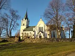 Sunne church in Värmland, Sweden | |
 Coat of arms | |
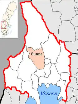 | |
| Coordinates: 59°50′N 13°08′E | |
| Country | Sweden |
| County | Värmland County |
| Seat | Sunne |
| Area | |
| • Total | 1,448.25 km2 (559.17 sq mi) |
| • Land | 1,288.11 km2 (497.34 sq mi) |
| • Water | 160.14 km2 (61.83 sq mi) |
| Area as of 1 January 2014. | |
| Population (31 December 2023)[2] | |
| • Total | 13,366 |
| • Density | 9.2/km2 (24/sq mi) |
| Time zone | UTC+1 (CET) |
| • Summer (DST) | UTC+2 (CEST) |
| ISO 3166 code | SE |
| Province | Värmland |
| Municipal code | 1766 |
| Website | www |
The present municipality was created in 1971 when the market town (köping) Sunne (instituted in 1920) was amalgamated with Gräsmark and Lysvik.
Localities
- Lysvik
- Mårbacka
- Rottneros
- Sunne (seat)
- Uddheden
- Västra Ämtervik
Karlstad, which has an international airport, is the nearest large city.
Demographics
This is a demographic table based on Sunne Municipality's electoral districts in the 2022 Swedish general election sourced from SVT's election platform, in turn taken from SCB official statistics.[3]
In total there were 13,352 inhabitants, with 10,393 Swedish citizens of voting age.[3] 44.0% voted for the left coalition and 54.8% for the right coalition. Indicators are in percentage points except population totals and income.
| Location | Residents | Citizen adults |
Left vote | Right vote | Employed | Swedish parents |
Foreign heritage |
Income SEK |
Degree |
|---|---|---|---|---|---|---|---|---|---|
| % | % | ||||||||
| Brobyäng | 1,326 | 1,023 | 48.2 | 51.3 | 77 | 85 | 15 | 20,908 | 29 |
| Gräsmark | 1,209 | 923 | 47.0 | 51.3 | 79 | 88 | 12 | 22,211 | 29 |
| Klockaregården | 1,681 | 1,253 | 44.1 | 54.4 | 71 | 84 | 16 | 23,102 | 28 |
| Leran | 1,607 | 1,291 | 45.8 | 53.0 | 78 | 83 | 17 | 23,726 | 32 |
| Lysvik | 1,285 | 990 | 49.6 | 49.8 | 84 | 91 | 9 | 23,979 | 34 |
| Rottneros | 805 | 648 | 39.0 | 60.2 | 82 | 89 | 11 | 26,517 | 29 |
| Stöpafors | 748 | 578 | 40.3 | 59.1 | 83 | 95 | 5 | 23,606 | 25 |
| Södra Borgeby | 1,525 | 1,189 | 39.5 | 59.2 | 84 | 91 | 9 | 25,945 | 32 |
| Västra Ämtervik | 1,024 | 787 | 45.5 | 53.2 | 84 | 92 | 8 | 25,484 | 36 |
| Åmberg | 1,337 | 1,055 | 42.8 | 57.1 | 80 | 92 | 8 | 25,168 | 32 |
| Östra Ämtervik | 805 | 656 | 42.0 | 56.5 | 84 | 92 | 8 | 24,212 | 39 |
| Source: SVT[3] | |||||||||
References
- "Statistiska centralbyrån, Kommunarealer den 1 januari 2014" (in Swedish). Statistics Sweden. 2014-01-01. Archived from the original (Microsoft Excel) on 2016-09-27. Retrieved 2014-04-18.
- "Folkmängd och befolkningsförändringar - Kvartal 4, 2023" (in Swedish). Statistics Sweden. February 22, 2024. Retrieved February 22, 2024.
- "Valresultat 2022 för Sunne i riksdagsvalet" (in Swedish). SVT. 11 September 2022. Retrieved 30 December 2023.
External links
 Media related to Sunne Municipality at Wikimedia Commons
- Official website
- Brobytornet - Project site
Municipalities and seats of Värmland County | ||
|---|---|---|
| Municipalities | ||
| Municipal seats | ||