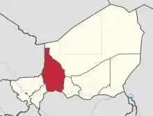
Tahoua Region
Tahoua is one of eight Regions of Niger. The capital of the region is the commune of Tahoua. The region covers 106,677 km².
Tahoua | |
|---|---|
 Location within Niger | |
| Coordinates: 14°53′N 5°16′E | |
| Country | |
| Capital | Tahoua |
| Area | |
| • Total | 106,677 km2 (41,188 sq mi) |
| Population (2020 estimate) | |
| • Total | 4,442,700 |
| • Density | 42/km2 (110/sq mi) |
| Time zone | UTC+1 (West Africa Time) |
| HDI (2021) | 0.353[1] low · 7th of 7 |
Geography
Tahoua borders Agadez Region to the northeast, Maradi Region to the southeast, Nigeria's Sokoto State to the south, and Mali (Gao and Kidal regions), Dosso Region and Tillabéri Region to the west. Much of the region lies with the Sahel, merging into the Sahara desert in the north.
Administrative subdivisions
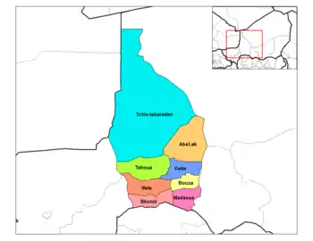
Departments of Tahoua (old borders)
Tahoua is divided into 12 Departments and one commune:
- Abalak Department
- Bagaroua Department
- Bkonni Department
- Bouza Department
- Illela Department
- Keita Department
- Madaoua Department
- Malbaza Department
- Tahoua Department
- Tahoua City
- Tassara Department
- Tchin-Tabaraden Department
- Tillia Department
Demographics
As of 2011 the population of Tahoua Region was 2,741,922.[3] The main ethnolinguistic groups are the Hausa , Fulani, Arabs and Tuareg.[4]
| Year | Pop. | ±% |
|---|---|---|
| 1977 | 993,615 | — |
| 1985 | 1,308,598 | +31.7% |
| 2001 | 1,972,907 | +50.8% |
| 2012 | 3,328,365 | +68.7% |
| source:[5] | ||
See also
- Regions of Niger
- Departments of Niger
- Communes of Niger
References
http://www.stat-niger.org/statistique/file/Affiches_Depliants/Nigerenchiffres2014def.pdf
- "Sub-national HDI - Area Database - Global Data Lab". hdi.globaldatalab.org. Retrieved 2018-09-13.
- "Niger: Region de Tahoua - Carte Administrative (au 4 juin 2014)" (PDF). UNOCHA. Retrieved 30 October 2019.
- Annuaire statistique du Niger
- "Languages of Niger". Ethnologue. Retrieved 24 October 2019.
- Niger: Administrative Division population statistics
- Portions of this article were translated from the French language Wikipedia article fr:Tahoua (région).
Capital: Niamey in Niamey Capital District | |
| Agadez Region |
|
| Diffa Region |
|
| Dosso Region |
|
| Maradi Region |
|
| Tahoua Region |
|
| Tillabéri Region |
|
| Zinder Region |
|
This article is issued from Wikipedia. The text is licensed under Creative Commons - Attribution - Sharealike. Additional terms may apply for the media files.