Tetulia Upazila
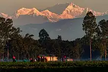
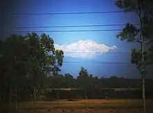
Tetulia (Bengali: তেতুলিয়া), historically spelt as Tentulia, is the northernmost region of Bangladesh, constituting an upazila in Panchagarh District of Rangpur Division.[1] Tetulia is geographically the northernmost tip of Bangladesh. Tetulia is notable for its tea. Tetulia is also notable for views of Mount Kangchenjunga, the third highest mountain in the world, from its plains, rivers and tea gardens.[2][3][4][5]
Tetulia
তেতুলিয়া | |
|---|---|
.jpg.webp) Tea garden in Tetulia | |
.svg.png.webp) | |
| Coordinates: 26°29′N 88°21′E | |
| Country | |
| Division | Rangpur |
| District | Panchagarh |
| Area | |
| • Total | 189.12 km2 (73.02 sq mi) |
| Population (2011) | |
| • Total | 125,454 |
| • Density | 660/km2 (1,700/sq mi) |
| Time zone | UTC+6 (BST) |
| Postal code | 5030 |
Etymology
Tentula is the Bengali word for tamarind.
Demographics
According to the 2011 Bangladesh census, Tetulia Upazila had 27,908 households and a population of 125,454. 30,869 (24.61%) were under 10 years of age. Tetulia had a literacy rate (age 7 and over) of 47.32%, compared to the national average of 51.8%, and a sex ratio of 977 females per 1000 males. 5,506 (4.39%) lived in urban areas.[6][7]
As of the 1991 Bangladesh census, Tetulia has a population of 86760. Males constitute 51.52% of the population, and females 48.48%. This Upazila's eighteen up population is 42021. Tetulia has an average literacy rate of 25.5% (7+ years), and the national average of 32.4% literate.[8]
Economy
The cultivation of tea, orange and pineapple is abundant in Tetulia. It is located on the Indian border with Darjeeling. A group name Kazi & Kazi has already introduced tea planting. Tea gardens have been established on plain land. Stone business is also flourishing here.
Points of interest
- Kazi & Kazi Tea Estate, Rowshanpur
- Banglabandha Land port
- Sharial Tea Garden
- Asian Highway
- Tetultola, Tetulia Chourasta
- Tetulia Gate
Administration
Tetulia Upazila is divided into seven union parishads: Banglabandha, Bhajanpur, Buraburi, Devnagar, Shalbahan, Tetulia, and Tirnaihat. The union parishads are subdivided into 36 mauzas and 246 villages.[6]
The post code of Tetulia is 5030.
Transport
Tetulia is connected by road. Nearby airport is "Saidpur Airport", which is 130 km from the town. Only Hanif Enterprise & keya Paribahan operate the bus service from Dhaka.
Gallery
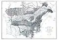 Titalia, 1891 map of Assam
_Map_of_the_Country_between_Titaleea_and_Dorjeling.jpg.webp) 1838 map of country between Titaleea and Darjeeling
1838 map of country between Titaleea and Darjeeling Titulya, on a 1776 map by James Rennell
References
- Shahidul Islam Shahid (2012). "Tentulia Upazila". In Sirajul Islam and Ahmed A. Jamal (ed.). Banglapedia: National Encyclopedia of Bangladesh (Second ed.). Asiatic Society of Bangladesh.
- https://www.tbsnews.net/feature/explorer/have-glimpse-kangchenjunga-panchagarh-151876
- https://bdnews24.com/lifestyle/magnificent-kanchenjunga-is-visible-from-tetulia
- https://www.tbsnews.net/features/explorer/see-mighty-kanchenjunga-bangladesh-529646
- https://www.thedailystar.net/weekend-read/news/calls-the-kanchenjunga-3166961
- "Bangladesh Population and Housing Census 2011 Zila Report – Panchagarh" (PDF). bbs.gov.bd. Bangladesh Bureau of Statistics.
- "Community Tables: Panchagarh district" (PDF). bbs.gov.bd. Bangladesh Bureau of Statistics. 2011.
- "Population Census Wing, BBS". Archived from the original on 2005-03-27. Retrieved November 10, 2006.
| Upazila/Thana: |
| |
|---|---|---|
Capital: Rangpur | ||
| Dinajpur District | 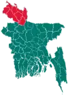 | |
| Gaibandha District |
| |
| Kurigram District |
| |
| Lalmonirhat District |
| |
| Nilphamari District |
| |
| Panchagarh District |
| |
| Rangpur District | ||
| Thakurgaon District |
| |