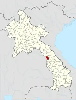
Thakhek
Thakhek (Lao language: ທ່າແຂກ, pronounced [tʰāː kʰɛ̏ːk]), the capital of Khammouane Province, is a town in south-central Laos on the Mekong River and the administrative centre of the district with the same name. The Third Thai–Lao Friendship Bridge, linking Thakhek and Nakhon Phanom, Thailand, across the river, started in 2009 and was opened on 11 November 2011.
Thakhek
ທ່າແຂກ | |
|---|---|
District & municipality | |
| Thakhek District | |
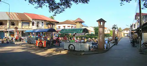 Thakhek centre | |
 Thakek District | |
 Thakhek Town location in Laos | |
| Coordinates: 17°24′N 104°48′E | |
| Country | |
| Province | Khammouane Province |
| District | Thakhek District |
| Population (2015)[1] | |
| • Total | 90,800 |
| Time zone | UTC+7 (ICT) |
The city has many French colonial style official buildings, villas, and shops. In 1943, 85% of the population of Thakhek were Vietnamese due to the French policy of encouraging Vietnamese immigrants to Laos.[2] Remnants of the abortive Thakhek-Tan Ap railway can be seen in and near the town. The railway would have run between Thakhek and Tân Ấp Railway Station, Quảng Bình Province, Vietnam through the Mụ Giạ Pass.

Western scientists first encountered the Laotian rock rat, kha nyou (Laonastes aenigmamus), in Thakhek's market.
.jpg.webp)
Climate
| Climate data for Thakhek (1991–2020) | |||||||||||||
|---|---|---|---|---|---|---|---|---|---|---|---|---|---|
| Month | Jan | Feb | Mar | Apr | May | Jun | Jul | Aug | Sep | Oct | Nov | Dec | Year |
| Mean daily maximum °C (°F) | 29.3 (84.7) |
31.2 (88.2) |
33.6 (92.5) |
34.8 (94.6) |
33.7 (92.7) |
32.0 (89.6) |
31.1 (88.0) |
30.8 (87.4) |
31.4 (88.5) |
31.6 (88.9) |
31.0 (87.8) |
29.1 (84.4) |
31.6 (88.9) |
| Daily mean °C (°F) | 24.2 (75.6) |
26.0 (78.8) |
28.6 (83.5) |
30.3 (86.5) |
29.7 (85.5) |
28.7 (83.7) |
28.1 (82.6) |
27.9 (82.2) |
28.1 (82.6) |
27.9 (82.2) |
26.6 (79.9) |
24.3 (75.7) |
27.5 (81.5) |
| Mean daily minimum °C (°F) | 16.4 (61.5) |
18.3 (64.9) |
21.9 (71.4) |
24.2 (75.6) |
24.9 (76.8) |
24.9 (76.8) |
24.6 (76.3) |
24.4 (75.9) |
24.0 (75.2) |
22.1 (71.8) |
19.6 (67.3) |
16.8 (62.2) |
21.8 (71.2) |
| Average precipitation mm (inches) | 4.2 (0.17) |
22.1 (0.87) |
50.8 (2.00) |
79.3 (3.12) |
238.9 (9.41) |
342.2 (13.47) |
545.9 (21.49) |
562.6 (22.15) |
314.0 (12.36) |
103.0 (4.06) |
13.4 (0.53) |
2.6 (0.10) |
2,279 (89.72) |
| Average precipitation days (≥ 1.0 mm) | 1 | 2 | 5 | 8 | 15 | 20 | 24 | 25 | 19 | 9 | 3 | 1 | 132 |
| Mean monthly sunshine hours | 253.4 | 223.9 | 215.4 | 216.7 | 196.3 | 137.7 | 129.4 | 119.3 | 147.2 | 208.1 | 238.9 | 253.8 | 2,340.1 |
| Source: NOAA[3] | |||||||||||||
References
- "Results of Population and Housing Census 2015" (PDF). Lao Statistics Bureau. Retrieved 19 February 2024.
- Stuart-Fox, Martin (1997). A History of Laos. Cambridge University Press. p. 51. ISBN 978-0-521-59746-3. Retrieved 15 April 2020.
- "World Meteorological Organization Climate Normals for 1991-2020 — Thakhek". National Oceanic and Atmospheric Administration. Retrieved January 17, 2024.
External links
 Thakhek travel guide from Wikivoyage
- Destination: Khammouane Province