Tibbitt to Contwoyto Winter Road
Tibbitt to Contwoyto Winter Road is an annual ice road first built in 1982 to service mines and exploration activities in the Northwest Territories and Nunavut in Northern Canada. Between 400 and 600 km (250 and 370 mi) long, the road is said to be the world's longest heavy haul ice road and operates for eight to ten weeks starting in the last week of January.[1][2][3] Most of the road (85%–87%) is built over frozen lakes, 495 km (308 mi), with the remaining 73 km (45 mi) built on over 64 land portages between lakes.[2][4][5]
Tibbitt to Contwoyto Winter Road | |
|---|---|
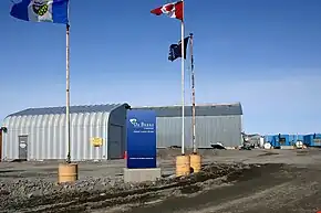 The entrance of De Beers' Snap Lake Diamond Mine, NT | |
| Route information | |
| Maintained by Nuna Logistics and RTL-Robinson | |
| Length | 600 km (370 mi) Can be as short as 400 km (250 mi) |
| Existed | 1982–present |
| Major junctions | |
| West end | Ingraham Trail, Northwest Territories |
| East end | Jericho Diamond Mine, Nunavut |
| Location | |
| Country | Canada |
| Highway system | |
|
| |
| |
|
| |
Construction and operation
The winter road is constructed by Nuna Logistics and RTL-Robinson every January and takes about six weeks to complete.[2][3][5] The first vehicle along each season is a Swedish-made Hägglund army-type reconnaissance vehicle designed to float if it falls through the ice; it tows an ice-thickness-detecting sonar.[2] This is followed by road building equipment including "specialized low ground pressure equipment".[2] The road, built extra wide to avoid blockages during blizzards and to allow opposing trucks to pass, is kept clear of snow, which acts as insulation, throughout the season as removal allows the ice to freeze faster and thicker.[2] The road is 50 m (160 ft) wide on the ice, but narrower on land portages ranging between 12 and 15 m (39 and 49 ft) wide. Once initially built, the road is checked by drilling holes into the ice. If the ice needs to be thickened, water trucks are called in to add water to that specific area. The road is only operational during February and March, an average of 67 days per year. The ice has been proven by engineers to support light vehicle loads at 70 cm (28 in) and increasing to full highway truck loads as the ice thickens.[5] A thickness of 107 cm (42 in) is required for a super B tanker carrying up to 50,000 L (11,000 imp gal; 13,000 US gal) and may weigh up to 42 t (41 long tons; 46 short tons).[6]
On some lakes, traffic may be re-routed to new lanes to avoid damaged or rough sections of ice, and additional "express lanes" allow returning, empty trucks to travel at higher speeds.
The highest allowable speed for fully loaded trucks on the ice is 25 km/h (16 mph) with some areas reduced to only 10 km/h (6.2 mph). Empty trucks have a maximum speed limit of 60 km/h (37 mph) on the ice. Speed limits are strictly enforced by security personnel with radar used to clock speeds just as national and provincial police forces do.[5][7]
There are three road camps servicing drivers hauling loads along the road, they are at: Dome Lake Maintenance Camp, Lockhart Lake and Lac de Gras.[5] Dome Lake is for maintenance crew and emergency use for drivers, Lockhart Lake provides drivers with food, shower, and a place to do laundry. Lac de Gras is for road crews, emergency use and for driver facilities for drivers travelling north of Ekati.
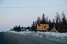
Truck drivers are not allowed to travel the winter road alone, therefore, up to four trucks are dispatched from Yellowknife every 20 minutes.[8] Heavy and wide loads are dispatched from Yellowknife between 12:00 am and 6:00 am to avoid daily commuter traffic.[4]
The main product shipped is diesel fuel and other material includes "cement, tires, prill (ammonium nitrate) for explosives manufacture, and construction materials."[3]
History
The Tibbitt to Contwoyto Ice Road follows part of the original road that was cleared to the Tundra Mine in 1960–1961 by John Denison. This road began at Discovery Mine which was already connected to Yellowknife by ice road up the Yellowknife River and swung east to Gordon Lake, heading north up Drybones, Lockhart and Mackay Lakes where the Tundra Mine was located. This route was used until 1968 when the mine closed.[9]
| Year | Opened | Closed | Freight carried | Super B capacity | Number of | ||
|---|---|---|---|---|---|---|---|
| Tonnes | Long tons | Short tons | reached | truck loads north | |||
| 2000 | January 29 | April 3 | 111,090 | 109,340 | 122,460 | n/a | 3,703 |
| 2001 | February 1 | April 13 | 245,586 | 241,707 | 270,712 | ~March 3 | 7,981 |
| 2002 | January 26 | April 16 | 256,915 | 252,857 | 283,200 | February 22 | 7,735 |
| 2003 | February 1 | April 2 | 198,818 | 195,678 | 219,159 | February 21 | 5,243 |
| 2004 | January 28 | March 31 | 179,144 | 176,315 | 197,472 | February 23 | 5,091 |
| 2005 | January 26 | April 5 | 252,533 | 248,545 | 278,370 | February 20 | 7,607 |
| 2006 | February 4 | March 26 | 177,674 | 174,868 | 195,852 | not reached | 6,841 |
| 2007 | January 27 | April 9 | 330,002 | 324,790 | 363,765 | February 26 | 10,922 |
| 2008 | January 29 | April 7 | 245,585 | 241,706 | 270,711 | February 15 | 7,484 |
| 2009 | February 1 | March 25 | 173,195 | 170,460 | 190,915 | February 15 | 5,377 |
| 2010 | February 4 | March 24 | 120,020 | 118,120 | 132,300 | TBA | 3,508 |
| 2011 | January 28 | March 31 | 239,000 | 235,000 | 263,000 | February 17 | 6,832 |
| 2012 | February 1 | March 28 | 210,188 | 206,868 | 231,693 | March 1 | 6,551 |
| 2013 | January 30 | March 31 | 223,206 | 219,681 | 246,042 | February 14 | 6,017 |
| 2014 | January 30 | April 1 | 243,928 | 240,076 | 268,885 | TBA | 7,069 |
| 2015 | January 30 | March 31 | 305,215 | 300,395 | 336,442 | TBA | 8,915 |
| 2016 | February 9 | Open 47 days | 262,261 | 258,119 | 289,093 | TBA | 8,766 |
| 2017 | February 1 | March 29 | 279,484 | 275,070 | 308,078 | TBA | 8,241 |
| 2018 | February 1 | Open 58 days | 303,725 | 298,928 | 334,800 | TBA | 8,209 |
| 2019 | February 1 | March 31 | 257,176 | 253,114 | 283,488 | TBA | 7,489 |
| 2020 | January 31 | April 8, open 60 days | 230,497 | 226,857 | 254,079 | TBA | 7,072 northbound 294 southbound |
| 2021 | February 8 | April 6, open 52 days | 210,126 | 206,807 | 231,624 | TBA | 6,102 northbound 225 southbound |
| 2022 | January 31 | March 31 (planned), open 65 days | 252,827 | 248,834 | 278,694 | TBA | 6,797 northbound 463 southbound |
| 2023 | February 6 | March 31 (planned), (actual after April 4, probably April 6), open 52 days | 213,509 | 210,137 | 235,353 | TBA | 6,014 northbound 534 southbound |
| 2024 | February 12 (planned) | On or before April 3 | TBA | March 2 | 6,400 | ||
The road was reopened in 1979 as part of an equipment haul to the new Lupin Mine at Contwoyto Lake, now Nunavut but then the NWT, pioneered by Robinson's Trucking and Hugh Arden. It followed the old Discovery Mine to Gordon Lake route. An experimental operation, Lupin decided not to continue using the road at this time and relied instead on Hercules C-130 aircraft to haul in machinery during construction of the mine.
In 1983, the ice road to Lupin Mine reopened as an economic alternative to yearly freight haul using aircraft.[5] The section between Tibbitt Lake (at the end of the Ingraham Trail) and Gordon Lake was built at this time. Another gold mine, the Salmita Mine (operated between 1983 and 1987) also benefited from this ice road.
Until 1998, the road was licensed and operated by Echo Bay Mines, owners of the Lupin Mine, after which it became a joint venture between Echo Bay Mines, BHP Billiton, and Diavik Diamond Mines.[4]
Since 1999, the road has been licensed and operated by the Tibbitt to Contwoyto Winter Road Joint Venture, today a partnership between BHP Billiton, Diavik Diamond Mines (Rio Tinto) and De Beers Canada. The road is engineered by Nor-Ex Ice Engineering, and, since 1998, Nuna Logistics, a 51% Inuit owned joint venture between the Nunasi Corporation, Kitikmeot Corporation and Nuna Management Group,[11] has been responsible for the annual construction, maintenance, dispatching, and camp catering for the primary road, with RTL Enterprises taking care of the secondary road.[2][5] Security on the road, provided by SecureCheck until 2009, is now provided by Det’on Cho Scarlet Security.[12] Det’on Cho is a Yellowknives Dene company with headquarters in N'Dilo and Scarlet Security, based in Yellowknife, is an Alarand affiliate.[13][14]
The year 2007 saw record usage of the ice road with 10,922 loads north, totalling 330,002 t (324,790 long tons; 363,765 short tons).[5] That record number doesn't include the 818 back hauls south,[5] totalling 15,000 t (15,000 long tons; 17,000 short tons). The road was open for 73 days from January 27 to April 9, only closed for a total of 91.5 hours (70 hours due to storms and 21.5 hours due to minor incidents). There were over 700 drivers registered during 2007 with nine accidents and one minor injury (a bruised shoulder).[1] During the record 2007 season, there were 99 verbal, 5 written warnings and 5 speeding violations.[7] Nine five-day suspensions and seven season suspensions were issued.[1]
In 2007 the road was featured on The History Channel series called Ice Road Truckers. The mining company that owned the road where the first season was filmed felt that the show portrayed the road in a negative fashion, and decided not to participate in future seasons of the show. A new rule for the Tibbitt to Contwoyto Winter Roads was enacted for the 2008 season prohibiting commercial, media, video or rolling film cameras either inside or attached to the outside of vehicle. The show's producers said that they had located an alternate ice road and that there would be a second season of the show;[15][16] the road featured in season 2 was the Tuktoyaktuk Winter Road.
Routes
Primary route
The ice road begins about 65 km (40 mi) east of Yellowknife at the end of Highway 4, more commonly known as the Ingraham Trail.[17]
From there, it winds its way north the following destinations:
| Distance | Location | Territory | Notes | |
|---|---|---|---|---|
| km | mi | |||
| 0 | 0 | Tibbitt Lake | NT | Start of roadmap 1 |
| 7 | 4.3 | Meadows Station | NT | Security checkpoint |
| 35 | 22 | Dome Lake | NT | Maintenance campmap 2 |
| 170 | 110 | Lockhart Lake | NT | Rest stopmap 3 |
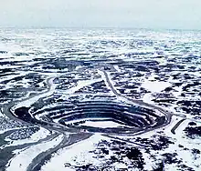
| 264 | 164 | Snap Lake Diamond Mine | NT | Owned by De Beers Canada and located southeast of the roadmap 4 |
| Gahcho Kue Diamond Mine | NT | Owned by a joint-venture between Mountain Province Diamonds and De Beers Canada, located southeast of the roadmap 5 | ||
| 350 | 220 | Lac de Gras | NT | Rest stop (for Lupin/Jericho traffic only)map 6 |
| 373 | 232 | Diavik Diamond Mine | NT | Owned by a joint venture between the Dominion Diamond Mines and Diavik Diamond Mines, a subsidiary of Rio Tinto Groupmap 7 |
| 378 | 235 | Misery | NT | Satellite mining camp of the Ekati Diamond Minemap 8 |
| 405 | 252 | Ekati Diamond Mine | NT | Owned by Dominion Diamond Mines, northwest of the roadmap 9 |
| Pellatt Lake | NT/NU | Crossing the NT/NU bordermap 10 | ||
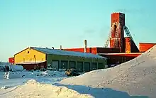
| 568 | 353 | Lupin Gold Mine | NU | Closed 2006, owned by Echo Bay Mines Limitedmap 11 |
| 600 | 370 | Jericho Diamond Mine | NU | Closed 2008, owned by Tahera Diamond Corporationmap 12 |
The road ends in Jericho Diamond Mine, at the north end of Contwoyto Lake, Nunavut. With the closing of the Lupin and Jericho mines, the road is no longer built to Contwoyto Lake. According to the 2020 JVTC Map book the road is shorted to 367km at the Ekati Mine on Lac De Gras.
Secondary route
The secondary route begins about 20 km (12 mi) east of Yellowknife at Prosperous Lake.map 13 The road heads north across the lake just to the west of Cassidy Pointmap 14 and through Quyta Lake where some of the earliest gold samples were found in 1933.map 15[18] From there the road continues north to Johnston Lakemap 16 and then northeast to Giauque Lake,map 17 with a road heading west to the old Discovery Mine, now the Yellowknife Gold Projectmap 18 operated by Tyhee Development.[19][20] From Giauque the road travels east across Thistlethwaite Lakemap 19 and northeast through Smokey Lakemap 20 before joining the main route just north of Gordon Lake.map 19[21]
Maps
Media
The ice road was the location of the first season of Ice Road Truckers.
This road inspired the Netflix movie The Ice Road.
See also
- Highways in Nunavut
- Wetum Road
References
- Tibbitt to Contwoyto Winter Road Joint Venture. "The Tibbitt to Contwoyto Winter Road". Retrieved April 26, 2020.
- "Tibbitt to Contwoyto Winter Road". NUNA Logistics. Retrieved April 26, 2020.
- "Supplying Canada's Northern Diamond Mines". JVTC Winter Road. Archived from the original on July 6, 2011.
- Nuna Logistics Ltd. "The Winter Road". Archived from the original on October 7, 2007. Retrieved August 15, 2007.
- "Facts". JVTC Winter Road. July 29, 2019. Retrieved April 27, 2020.
- "Construction: Backed by Experience, Monitored with Science". JVTC Winter Road. July 29, 2019. Retrieved April 27, 2020.
- "Security". JVTC Winter Road. July 29, 2019. Retrieved April 27, 2020.
- "Safety". JVTC Winter Road. July 29, 2019. Retrieved April 27, 2020.
- "1959 John Denison's Ice Roads". NWT Historical Timeline. Prince of Wales Northern Heritage Centre. Archived from the original on February 17, 2012.
- "2010 Winter Road Updates". Archived from the original on July 6, 2011.
- Nuna Logistics
- "New partnership for Deton'Cho Corp". Archived from the original on March 25, 2012.
- "Deton'Cho - Contact". Archived from the original on November 16, 2010.
- "Scarlet Security". Archived from the original on September 13, 2012.
- "Tibbitt to Contwoyto Winter Road 2008 orientation materials" (PDF). Archived from the original (PDF) on October 1, 2011. Retrieved September 30, 2013.
- "Producers find new ice road for TV series". Landline Magazine. Owner-Operator Independent Drivers Association. February 5, 2008. Archived from the original on February 9, 2008. Retrieved February 21, 2008.
- Maps
- "Northwest Territories Timeline - "Yellowknife Johnny" Baker". Prince of Whales Northern Heritage Centre. Archived from the original on August 31, 2006. Retrieved January 23, 2008.
- "GoldMining Completes Acquisition of Yellowknife Gold Project and Big Sky Property". www.newswire.ca. July 21, 2017. Retrieved October 1, 2019.
- Canadian Diamond Mine Winter Road
- "Secondary route" (PDF). Archived from the original (PDF) on July 6, 2011.
External links
- NWT Road Reports at the Government of Northwest Territories
Roads and highways in the Northwest Territories | ||
|---|---|---|
| Highways |
| |
| Other roads |
| |