Tolitoli Regency
Tolitoli Regency is a regency of Central Sulawesi Province of Indonesia. It was previously part of a larger Buol Tolitoli Regency (including the current Buol Regency), but this was split into two on 4 October 1999 after rapid decentralization of the Indonesian government. The present Tolitoli Regency covers an area of 3,701.54 km2 and had a population of 211,296 at the 2010 Census[2] and 225,154 at the 2020 Census;[3] the official estimate as at mid 2023 was 231,711, comprising 118,180 male and 113,530 female inhabitants.[1] Its regency seat is located at the town of Tolitoli (in Baolan District), which is a port town and where the regency's population is concentrated.
Tolitoli Regency
Kabupaten Tolitoli | |
|---|---|
 Coat of arms | |
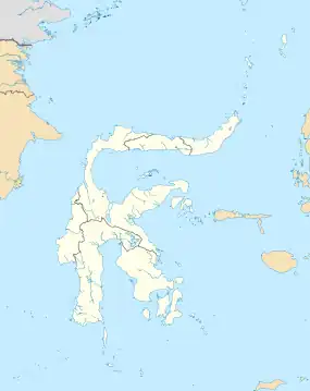
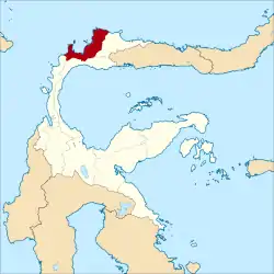 Location within Central Sulawesi | |
| Coordinates: 1°02′19″N 120°49′04″E | |
| Country | Indonesia |
| Province | Central Sulawesi |
| Capital | Tolitoli |
| Government | |
| • Regent | Mohammad Saleh Bantilan |
| • Vice Regent | Abdul Rahman |
| Area | |
| • Total | 3,701.54 km2 (1,429.17 sq mi) |
| Population (mid 2023 estimate)[1] | |
| • Total | 231,711 |
| • Density | 63/km2 (160/sq mi) |
| Time zone | UTC+8 (ICST) |
| Area code | (+62) 453 |
| Website | tolitolikab |
Administrative districts
The Tolitoli Regency was divided in 2020 into ten districts (kecamatan), which are tabulated below with their areas and their populations at the 2010 Census[2] and the 2020 Census,[3] together with the official estimates as at mid 2023.[1] The table also includes the location of the district administrative centres, the number of administrative villages in each district (totalling 103 rural desa and 6 urban kelurahan in total), and its post code.
| Kode Wilayah | Name of District (kecamatan) | Area in km2 (a) | Pop'n Census 2010 | Pop'n Census 2020 | Pop'n Estimate mid 2023 | Admin centre | No. of villages | Post code |
|---|---|---|---|---|---|---|---|---|
| 72.04.01 | Dampal Selatan (South Dampal) | 392.67 | 21,394 | 21,620 | 21,890 | Bangkir | 13 | 94554 |
| 72.04.02 | Dampal Utara (b) (North Dampal) | 182.88 | 14,390 | 13,900 | 14,030 | Ogotua | 12 | 94553 |
| 72.04.03 | Dondo | 542.50 | 21,358 | 22,650 | 23,260 | Tinabogan | 16 | 94551 |
| 72.04.05 | Ogo Deide (c) | 412.13 | 11,682 | 12,270 | 12,560 | Bib | 11 | 94516 |
| 72.04.04 | Basidondo | 441.30 | 10,458 | 10,750 | 10,940 | Kayulompa | 10 | 94552 |
| 72.04.07 | Baolan | 258.03 | 63,072 | 67,600 | 69,630 | Baru | (d) 10 | 94511 - 94517 |
| 72.04.06 | Lampasio | 626.00 | 11,875 | 12,850 | 13,270 | Sibea | 9 | 94517 & 94518 |
| 72.04.08 | Galang | 597.76 | 31,701 | 35,720 | 37,320 | Lalos | 14 | 94561 |
| 72.04.09 | Tolitoli Utara (North Toli-Toli) | 405.50 | 16,940 | 18,180 | 18,730 | Laulalang | 10 | 94560 |
| 72.04.10 | Dako Pamean | 221.00 | 8,426 | 9,630 | 10,100 | Galumpang | 4 | 94562 |
| Totals | 4,079.77 | 211,296 | 225,154 | 231,711 | Tolitoli | 109 |
Notes: (a) according to Badan Pusat Statistik, the area of Tolitoli Regency has been revised to 3,701.54 km2, but figures for the districts are not yet (2023) available. (b) including 7 offshore islands, the largest being Pulau Simatang off the north coast of the district.
(c) including 29 offshore islands, the largest being Pulau Kabetan off the northwest coast of the district.
(d) including all six kelurahan (urban villages) in the regency, namely Baru, Nalu, Panasakan, Sidoarjo, Tambun and Tuweley.
Climate
Tolitoli has a tropical rainforest climate (Af) with moderate rainfall in March and April and heavy rainfall in the remaining months.
| Climate data for Tolitoli | |||||||||||||
|---|---|---|---|---|---|---|---|---|---|---|---|---|---|
| Month | Jan | Feb | Mar | Apr | May | Jun | Jul | Aug | Sep | Oct | Nov | Dec | Year |
| Mean daily maximum °C (°F) | 30.5 (86.9) |
30.6 (87.1) |
30.9 (87.6) |
31.2 (88.2) |
31.4 (88.5) |
30.8 (87.4) |
30.4 (86.7) |
31.3 (88.3) |
31.5 (88.7) |
32.2 (90.0) |
31.6 (88.9) |
31.1 (88.0) |
31.1 (88.0) |
| Daily mean °C (°F) | 26.6 (79.9) |
26.7 (80.1) |
26.9 (80.4) |
27.0 (80.6) |
27.4 (81.3) |
26.8 (80.2) |
26.4 (79.5) |
27.0 (80.6) |
26.9 (80.4) |
27.5 (81.5) |
27.2 (81.0) |
27.1 (80.8) |
27.0 (80.5) |
| Mean daily minimum °C (°F) | 22.7 (72.9) |
22.8 (73.0) |
22.9 (73.2) |
22.9 (73.2) |
23.4 (74.1) |
22.9 (73.2) |
22.4 (72.3) |
22.7 (72.9) |
22.4 (72.3) |
22.8 (73.0) |
22.9 (73.2) |
23.1 (73.6) |
22.8 (73.1) |
| Average rainfall mm (inches) | 256 (10.1) |
169 (6.7) |
108 (4.3) |
117 (4.6) |
174 (6.9) |
194 (7.6) |
274 (10.8) |
166 (6.5) |
154 (6.1) |
164 (6.5) |
194 (7.6) |
177 (7.0) |
2,147 (84.7) |
| Source: Climate-Data.org[4] | |||||||||||||
References
- Badan Pusat Statistik, Jakarta, 28 February 2024, Kabupaten Tolitoli Dalam Angka 2024 (Katalog-BPS 1102001.7204)
- Biro Pusat Statistik, Jakarta, 2011.
- Badan Pusat Statistik, Jakarta, 2021.
- "Climate: Tolitoli". Climate-Data.org. Retrieved 21 November 2020.
External links
- (in Indonesian) Local Government of Tolitoli Regency
Regencies and cities of Central Sulawesi | ||
|---|---|---|
Capital: Palu | ||
| Regencies |
| |
| Cities | ||