Trincomalee District
Trincomalee District (Tamil: திருக்கோணமலை மாவட்டம் Tirukkōṇamalai Māvaṭṭam; Sinhala: ත්රිකුණාමළය දිස්ත්රික්කය Trikuṇāmalaya distrikkaya) is one of the 25 districts of Sri Lanka, the second level administrative division of the country. The district is administered by a District Secretariat headed by a District Secretary (previously known as a Government Agent) appointed by the central government of Sri Lanka. The capital of the district is the city of Trincomalee.
Trincomalee District
திருக்கோணமலை மாவட்டம் ත්රිකුණාමළය දිස්ත්රික්කය | |
|---|---|
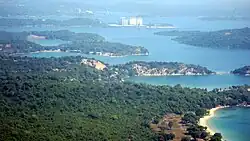 Trincomalee Bay | |
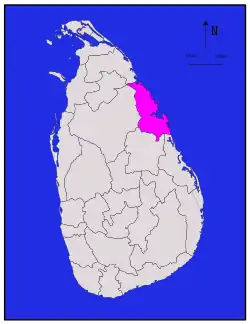 Location within Sri Lanka | |
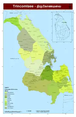 Administrative units of Trincomalee District in 2006 | |
| Coordinates: 08°35′N 81°05′E | |
| Country | Sri Lanka |
| Province | Eastern |
| Capital | Trincomalee |
| DS Division | List
|
| Government | |
| • District Secretary | J. S. D. M. Asanka Abeywardena |
| • MPs | List
|
| • MPCs | List
|
| Area | |
| • Total | 2,727 km2 (1,053 sq mi) |
| • Land | 2,529 km2 (976 sq mi) |
| • Water | 198 km2 (76 sq mi) 7.26% |
| • Rank | 11th (4.16% of total area) |
| Population (2012 census)[1] | |
| • Total | 378,182 |
| • Rank | 21st (1.87% of total pop.) |
| • Density | 140/km2 (360/sq mi) |
| Ethnicity (2012 census)[1] | |
| • Moor | 163,982 (40.43%) |
| • Sri Lankan Tamil | 115,549 (30.55%) |
| • Sinhalese | 101,991 (26.97%) |
| • Indian Tamil | 6,531 (1.73%) |
| • Other | 1,257 (0.33%) |
| Religion (2012 census)[2] | |
| • Muslim | 166,200 (42.12%) |
| • Buddhist | 98,772 (26.12%) |
| • Hindu | 98,133 (25.95%) |
| • Christian | 21,892 (5.79%) |
| • Other | 134 (0.04%) |
| Time zone | UTC+05:30 (Sri Lanka) |
| Post Codes | 31000-31999 |
| Telephone Codes | 026 |
| ISO 3166 code | LK-53 |
| Vehicle registration | EP |
| Official Languages | Tamil, Sinhala |
| Website | Trincomalee District Secretariat |
Geography
Trincomalee District is located in the east of Sri Lanka in the Eastern Province. It has an area of 2,727 square kilometres (1,053 sq mi).[3]
Etymology
Trincomalee
The city has developed from a village settlement on the promontory dedicated to the Hindu shrine. The origin of the term Ko, Kone and Konatha lies in the Old Tamil word for the terms "Lord", "King" or "Chief", which allude to the deity that presides here; this term appears in several Tamil Brahmi inscriptions of the 6th century BCE — 2nd century CE. Trincomalee, the coastal peninsula town where Koneswaram is located is an anglicized form of the old Tamil word "Thiru-kona-malai" (Tamil: திருகோணமலை), meaning "Lord of the Sacred Hill", its earliest reference in this form found in the Tevaram of the 7th century by Sambandhar. Thiru is a generally used epithet denoting a "sacred" temple site while Malai means mountain or hill; Middle Tamil manuscripts and inscriptions mention the monumental compound shrine as the Thirukonamalai Konesar Kovil.[4][5][6][7] Kona (Tamil: கோண) has other meanings in Old Tamil such as peak, while another origin for the term Koneswaram could come from the Tamil term Kuna (East). Therefore, other translators suggest definitions of Trincomalee such as "sacred angular/peaked hill", "sacred eastern hill" or "three peaked hill".[8][9][10] The temple was constructed atop Swami Rock, also called Swami Malai or Kona-ma-malai, a cliff on the peninsula that drops 400 feet (120 metres) directly into the sea.[4][11][12]
Administrative units
Trincomalee District is divided into 11 Divisional Secretary's Division (DS Divisions), each headed by a Divisional Secretary (previously known as an Assistant Government Agent).[13] The DS Divisions are further sub-divided into 230 Grama Niladhari Divisions (GN Divisions).[13]
| DS Division | Main Town | Divisional Secretary | GN Divisions |
Area (km2) [14] |
Population (2012 Census)[15] | Population Density (/km2) | |||||
|---|---|---|---|---|---|---|---|---|---|---|---|
| Sri Lankan Moors | Sri Lankan Tamil | Sinhalese | Indian Tamil | Other | Total | ||||||
| Gomarankadawala | Gomarankadawala | S. M. C. Samarakoon | 10 | 288 | 1 | 25 | 7,313 | 0 | 0 | 7,339 | 25 |
| Kantalai | Kantalai | K. Premadasha | 23 | 404 | 5,108 | 1,534 | 37,448 | 2,478 | 73 | 46,641 | 115 |
| Kinniya | Kinniya | M. A. Anas | 31 | 165 | 58,447 | 2,522 | 19 | 3,445 | 18 | 64,451 | 391 |
| Kuchchaveli | Kuchchaveli | P. Thaneswaran | 24 | 438 | 21,307 | 10,553 | 1,193 | 40 | 7 | 33,100 | 76 |
| Morawewa (Muthalikkulam) | Morawewa | W. M. Bathiya Vijayantha | 10 | 329 | 1,300 | 888 | 5,750 | 3 | 5 | 7,946 | 24 |
| Muttur | Muttur | V. Yoosuf | 42 | 195 | 34,984 | 20,935 | 444 | 4 | 12 | 56,379 | 289 |
| Padavi Siripura | Siripura | V. P. S. Jinadrasena | 10 | 152 | 1 | 10 | 11,846 | 0 | 1 | 11,858 | 78 |
| Seruvila | Seruvila | P. R. Jayarathna | 17 | 311 | 2,426 | 1,816 | 9,293 | 3 | 8 | 13,546 | 44 |
| Thampalakamam (Thambalagamuwa) | Thampalakamam | J. Sripathy | 12 | 226 | 16,164 | 4,701 | 7,476 | 0 | 15 | 28,356 | 125 |
| Trincomalee Town & Gravets | Trincomalee | J.H.Arulraj | 42 | 148 | 13,113 | 61,282 | 21,179 | 546 | 1,114 | 97,234 | 657 |
| Verugal & Eachchalampattu | Verugal | P. Thanesvaran | 9 | 71 | 3 | 11,283 | 30 | 12 | 4 | 11,332 | 160 |
| Total | 230 | 2,727 | 152,854 | 115,549 | 101,991 | 6,531 | 1,257 | 378,182 | 139 | ||
Demographics
Population
Trincomalee District's population was 378,182 in 2012.[1]
The population of the district, like the rest of the east and north, has been heavily affected by the civil war. The war killed an estimated 100,000 people.[16] Several hundred thousand Sri Lankan Tamils, possibly as much as one million, emigrated to the West during the war.[17]
Ethnicity
| Year | Muslim[lower-alpha 1] | Tamil[lower-alpha 2] | Sinhalese | Other | Total No. | ||||
|---|---|---|---|---|---|---|---|---|---|
| No. | % | No. | % | No. | % | No. | % | ||
| 1827 | 3,245 | 16.94% | 15,663 | 81.76% | 250 | 1.30% | 0 | 0.00% | 19,158 |
| 1881 Census | 5,746 | 25.89% | 14,304 | 64.44% | 935 | 4.21% | 1,212 | 5.46% | 22,197 |
| 1891 Census | 6,426 | 24.96% | 17,117 | 66.49% | 1,105 | 4.29% | 1,097 | 4.26% | 25,745 |
| 1901 Census | 8,258 | 29.04% | 17,060 | 59.98% | 1,203 | 4.23% | 1,920 | 6.75% | 28,441 |
| 1911 Census | 9,700 | 32.60% | 17,233 | 57.92% | 1,138 | 3.82% | 1,684 | 5.66% | 29,755 |
| 1921 Census | 12,846 | 37.66% | 18,580 | 54.47% | 1,501 | 4.40% | 1,185 | 3.47% | 34,112 |
| 1946 Census | 23,219 | 30.58% | 33,795 | 44.51% | 11,606 | 15.29% | 7,306 | 9.62% | 75,926 |
| 1953 Census | 28,616 | 34.10% | 37,517 | 44.71% | 15,296 | 18.23% | 2,488 | 2.96% | 83,917 |
| 1963 Census | 40,775 | 29.43% | 54,452 | 39.30% | 39,925 | 28.82% | 3,401 | 2.45% | 138,553 |
| 1971 Census | 59,924 | 31.83% | 71,749 | 38.11% | 54,744 | 29.08% | 1,828 | 0.97% | 188,245 |
| 1981 Census | 75,039 | 29.32% | 93,132 | 36.39% | 85,503 | 33.41% | 2,274 | 0.89% | 255,948 |
| 2001 Census[lower-alpha 3] | n/a | n/a | n/a | n/a | n/a | n/a | n/a | n/a | n/a |
| 2007 Enumeration | 151,692 | 45.37% | 96,142 | 28.75% | 84,766 | 25.35% | 1,763 | 0.53% | 334,363 |
| 2012 Census | 152,854 | 40.42% | 122,080 | 32.29% | 101,991 | 26.97% | 1,257 | 0.33% | 378,182 |
Religion
| Year | Islam | Buddhist | Hindu | Christian[lower-alpha 4] | Others | Total No. | |||||
|---|---|---|---|---|---|---|---|---|---|---|---|
| No. | % | No. | % | No. | % | No. | % | No. | % | ||
| 1981 Census | 76,404 | 29.85% | 82,602 | 32.27% | 80,843 | 31.59% | 15,583 | 6.09% | 516 | 0.20% | 255,948 |
| 2012 Census | 159,251 | 42.11% | 98,772 | 26.12% | 98,133 | 25.95% | 21,892 | 5.79% | 134 | 0.04% | 378,182 |
Poverty
In 2016, the district was one of the poorest in Sri Lanka and had the third-highest incidence of extreme poverty according to the World Bank.[21]
Politics and government
Local government
Trincomalee District has 13 local authorities of which two are Urban Councils and the remaining 11 are Divisional Councils (Pradesha Sabhai or Pradeshiya Sabha).[22]
| Local Authority | Area | Population | Registered Electors (2011) |
Elected Members (2011) | ||||
|---|---|---|---|---|---|---|---|---|
| UPFA | TNA | UNP | Other | Total | ||||
| Gomarankadawala Divisional Council | 5,831 | 8 | 0 | 1 | 0 | 9 | ||
| Kantalai Divisional Council | 397.3 | 48,632 | 30,898 | 8 | 0 | 3 | 0 | 11 |
| Kinniya Divisional Council | 16,626 | 5 | 0 | 2 | 0 | 7 | ||
| Kinniya Urban Council | 9.5 | 44,034 | 21,069 | 5 | 0 | 1 | 1 | 7 |
| Kuchchaveli Divisional Council | 333.3 | 29,967 | 20,872 | 6 | 2 | 1 | 0 | 9 |
| Morawewa Divisional Council | 116.0 | 10,000 | 8,659 | 6 | 0 | 3 | 0 | 9 |
| Muttur Divisional Council | 179.4 | 60,000 | 37,731 | 7 | 3 | 1 | 0 | 11 |
| Padavi Siripura Divisional Council | 217.1 | 13,000 | 8,362 | 6 | 0 | 1 | 2 | 9 |
| Seruvila Divisional Council | 277.0 | 13,886 | 9,130 | 7 | 1 | 1 | 0 | 9 |
| Thampalakamam Divisional Council | 244.0 | 33,967 | 17,125 | 6 | 0 | 3 | 0 | 9 |
| Trincomalee Town and Gravets Divisional Council | 31,791 | 3 | 5 | 1 | 0 | 9 | ||
| Trincomalee Urban Council | 7.5 | 101,958 | 31,927 | 2 | 8 | 1 | 1 | 12 |
| Verugal Divisional Council | 5,894 | 1 | 5 | 0 | 1 | 7 | ||
| Total | 245,915 | 70 | 24 | 19 | 5 | 118 | ||
Notes
- Sri Lankan Moors and Indian Moors.
- Sri Lankan Tamil and Indian Tamil.
- 2001 Census was only carried out partially in Trincomalee District.
- Roman Catholic and Other Christian.
References
- "A2 : Population by ethnic group according to districts, 2012". Census of Population & Housing, 2011. Department of Census & Statistics, Sri Lanka.
- "A3 : Population by religion according to districts, 2012". Census of Population & Housing, 2011. Department of Census & Statistics, Sri Lanka.
- "Area of Sri Lanka by province and district" (PDF). Statistical Abstract 2011. Department of Census & Statistics, Sri Lanka. Archived from the original (PDF) on 2012-11-13.
- E Greig, Doreen (1987). "The reluctant colonists: Netherlanders abroad in the 17th and 18th centuries". U.S.A.: Assen, The Netherlands; Wolfeboro, N.H., U.S.A.: 227. OCLC 14069213.
{{cite journal}}: Cite journal requires|journal=(help) - Sivaratnam, C (1964). An outline of the cultural history and principles of Hinduism (1 ed.). Colombo: Stangard Printers. OCLC 12240260.
Koneswaram temple. Tiru-Kona-malai, sacred mountain of Kona or Koneser, Iswara or Siva. The date of building the original temple is given as 1580, BCE. according to a Tamil poem by Kavi Raja Virothayan translated into English in 1831 by Simon Cassie Chitty...
- Herbert Keuneman; John Gottberg; Ravindralal Anthonis; Hans Hoefer (1985). Sri Lanka (3 ed.). Hong Kong: Hong Kong : Apa Productions (HK); [Englewood Cliffs, N.J. : Distributed by] Prentice Hall, 1985. p. 214. ISBN 978-0-13-839944-3. OCLC 13501485.
- Indrapala, Karthigesu (2007). The evolution of an ethnic identity: The Tamils in Sri Lanka C. 300 BCE to C. 1200 CE. Colombo: Vijitha Yapa. p. 324. ISBN 978-955-1266-72-1.
- Ramachandran, Nirmala (2004). The Hindu legacy to Sri Lanka. Pannapitiya: Stamford Lake (Pvt.) Ltd. 2004. ISBN 978-955-8733-97-4. OCLC 230674424.
- Taylor, Isaac (1843). Names and Their Histories: A Handbook of Historical Geography and Topographical Nomenclature. London: BiblioBazaar, LLC. p. 308. ISBN 0-559-29668-1.
- Room, Adrian (2006). Placenames of the world : origins and meanings of the names for 6,600 countries, cities, territories, natural features, and historic sites (2 ed.). London: Jefferson, N.C.; London : McFarland & Co., cop. 2006. p. 382. ISBN 978-0-7864-2248-7. OCLC 439732470.
- "Tirukōṇa-malai (Trincomalee), Kīri-malai, Kutirai-malai". TamilNet. July 1, 2007.
- "Aayiththiyamalai". TamilNet. October 24, 2010.
- "Overview". Trincomalee District Secretariat.
- "Land area by province, district and divisional secretariat division" (PDF). Statistical Abstract 2011. Department of Census & Statistics, Sri Lanka. Archived from the original (PDF) on 2013-12-15.
- "A6 : Population by ethnicity and district according to Divisional Secretary's Division, 2012". Census of Population & Housing, 2011. Department of Census & Statistics, Sri Lanka.
- "Up to 100,000 killed in Sri Lanka's civil war: UN". ABC News (Australia). 20 May 2009.
- Harrison, Frances (23 July 2003). "Twenty years on – riots that led to war". BBC News.
- "Special Enumeration 2007, Trincomalee" (PDF). Department of Census & Statistics, Sri Lanka.
- "Demographic Changes by the LTTE Peace Secretariat, April 2008" (PDF). Sangam.
- "Population by religion and district, Census 1981, 2001" (PDF). Statistical Abstract 2011. Department of Census & Statistics, Sri Lanka. Archived from the original (PDF) on 2013-12-15.
- "Geospatial Poverty Portal: Interactive Maps". World Bank. Retrieved 2024-01-22.
- "Local Authorities". Trincomalee District Secretariat.