Ulricehamn Municipality
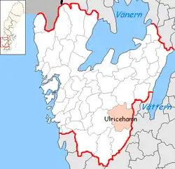
Ulricehamn Municipality (Ulricehamns kommun) is a municipality in Västra Götaland County in western Sweden. Its seat is located in the city of Ulricehamn.
Ulricehamn Municipality
Ulricehamns kommun | |
|---|---|
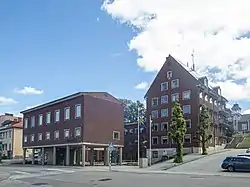 Ulricehamn town hall | |
 Coat of arms | |
 | |
| Coordinates: 57°47′N 13°25′E | |
| Country | Sweden |
| County | Västra Götaland County |
| Seat | Ulricehamn |
| Area | |
| • Total | 1,116.71 km2 (431.16 sq mi) |
| • Land | 1,046.02 km2 (403.87 sq mi) |
| • Water | 70.69 km2 (27.29 sq mi) |
| Area as of 1 January 2014. | |
| Population (31 December 2023)[2] | |
| • Total | 25,087 |
| • Density | 22/km2 (58/sq mi) |
| Time zone | UTC+1 (CET) |
| • Summer (DST) | UTC+2 (CEST) |
| ISO 3166 code | SE |
| Province | Västergötland |
| Municipal code | 1491 |
| Website | www.ulricehamn.se |
The present municipality was created in 1974 when the former City of Ulricehamn was merged with three former rural municipalities (themselves established through amalgamations of minor units in 1952).
Localities
- Blidsberg
- Dalum
- Gällstad
- Hulu
- Hökerum
- Marbäck
- Nitta
- Rånnaväg
- Timmele
- Trädet
- Ulricehamn (seat)
- Vegby
- Älmestad
Demographics
This is a demographic table based on Ulricehamn Municipality's electoral districts in the 2022 Swedish general election sourced from SVT's election platform, in turn taken from SCB official statistics.[3]
In total there were 24,871 residents, including 18,972 Swedish citizens of voting age.[3] 43.9% voted for the left coalition and 54.8% for the right coalition.
| Location | Residents | Citizen adults |
Left vote | Right vote | Employed | Swedish parents |
Foreign heritage |
Income SEK |
Degree |
|---|---|---|---|---|---|---|---|---|---|
| % | % | ||||||||
| Blidsberg/Dalum | 2,089 | 1,571 | 38.0 | 59.9 | 79 | 82 | 18 | 22,233 | 27 |
| Centrum/Tingsholm N | 1,692 | 1,409 | 47.9 | 51.2 | 79 | 78 | 22 | 21,756 | 34 |
| Fridhem/Paradiset/C-S | 2,028 | 1,641 | 44.7 | 54.3 | 83 | 85 | 15 | 26,372 | 38 |
| Gunnarshill | 1,648 | 1,201 | 50.4 | 48.3 | 85 | 76 | 24 | 26,758 | 36 |
| Gällstad/Rånnaväg | 2,113 | 1,611 | 46.1 | 52.8 | 84 | 83 | 17 | 24,464 | 27 |
| Hökerum/Nitta | 2,451 | 1,838 | 40.4 | 58.2 | 87 | 88 | 12 | 26,465 | 32 |
| Hössna/Liared | 1,479 | 1,098 | 35.7 | 63.0 | 85 | 89 | 11 | 25,736 | 30 |
| Marbäck/Fredriksberg | 2,385 | 1,760 | 48.5 | 50.3 | 87 | 85 | 15 | 28,334 | 42 |
| Markuslyckan/Karlslätt | 1,525 | 1,094 | 48.9 | 49.1 | 82 | 71 | 29 | 25,533 | 34 |
| Skarpås/Furet | 1,695 | 1,279 | 46.2 | 52.8 | 85 | 80 | 20 | 26,847 | 35 |
| Timmele/Älmestad | 2,024 | 1,599 | 37.8 | 61.4 | 86 | 90 | 10 | 25,893 | 28 |
| Tvärred/Vegby | 2,059 | 1,514 | 45.7 | 53.2 | 83 | 82 | 18 | 25,968 | 32 |
| Villastaden/Bronäs | 1,683 | 1,357 | 44.3 | 54.7 | 83 | 82 | 18 | 24,739 | 33 |
| Source: SVT[3] | |||||||||
References
- "Statistiska centralbyrån, Kommunarealer den 1 januari 2014" (in Swedish). Statistics Sweden. 2014-01-01. Archived from the original (Microsoft Excel) on 2016-09-27. Retrieved 2014-04-18.
- "Folkmängd och befolkningsförändringar - Kvartal 4, 2023" (in Swedish). Statistics Sweden. February 22, 2024. Retrieved February 22, 2024.
- "Valresultat 2022 för Ulricehamn i riksdagsvalet" (in Swedish). SVT. 11 September 2022. Retrieved 4 February 2024.
External links
 Media related to Ulricehamn Municipality at Wikimedia Commons
- Ulricehamn Municipality - Official site
- Ulricehamn Tourism - In Swedish, English and German
- (in Swedish) Article Ulricehamn - From Nordisk Familjebok
Places adjacent to Ulricehamn Municipality | |
|---|---|
This article is issued from Wikipedia. The text is licensed under Creative Commons - Attribution - Sharealike. Additional terms may apply for the media files.