Vacomagi
The Vacomagi were a people of ancient Britain, known only from a single mention of them by the geographer Claudius Ptolemy (AD c.100–c.170).[lower-alpha 1] Their principal places are known from Ptolemy's map c.150 of Albion island of Britannia – from the First Map of Europe.[1][Web 1]
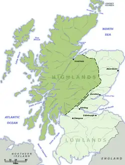
The Vacomagi were a confederacy of smaller tribes, each one a separate polity with its own hierarchy of leaders. According to the data collected by Ptolemy,[lower-alpha 2] the Vacomagi were spread over a wide area between the Moray Firth and the Firth of Forth; to the east of the Cairngorms and north of the Clyde–Forth isthmus.[lower-alpha 3]
Name
Terminology
..."Warriors from Northern Briton
fought naked and used narrow shields,
a spear and a sword...[2]
— Herodian (c.170–c.240).
The term Vacomagi was used by the Romans to distinguish between those Caledonians whose territory was in the lower plains to the east of the Grampian Mountains, from the Caledonii whose territory was in the Highland glens further west. Ptolemy's map is the only classical source to mention the Vacomagi by name; other classical sources generally used a generic term, for example Britons or Caledonians.[lower-alpha 4]
Terminology — from 2nd century AD to 4th century AD:[lower-alpha 5]
| Modern name | Ptolemy | Other sources[lower-alpha 6] | Geographic area |
|---|---|---|---|
| Caledonians | ? | Caledonians[lower-alpha 7] Britannis ..."Britons" Picti ..."Picts"[lower-alpha 8] |
North of the Clyde–Forth isthmus. |
| Caledones | Caledonii | Caledones | Highland glens to the east of Loch Ness and the Great Glen Fault. |
| Vacomagi | Vacomagi | Caledones[lower-alpha 9] | Lower plains to the east of the Grampian Mountains. |
Etymology
The name was probably a derisory insult to the enemy of the Roman army:[lower-alpha 6]
- Latin <vaco> ..."lazy, idle".
- Latin <magi> ...plural of magus.
- Latin <magus> ..."sorcerer, trickster, conjurer".
The Picts (descendants of the Vacomagi)[lower-alpha 10] are reported to have believed in the magi – people with supernatural powers; for example the magus Broichan, who was alleged to have the ability to influence the weather.[lower-alpha 11][lower-alpha 12]
Ptolemy's map
Principal places

..."below Caledonia are the Vacomagi, among whom are the following settlements:[lower-alpha 13]
— Claudius Ptolemy (AD c.100–c.170)
- Moray Firth
- Pinnata Castra
- Tuesis
- Firth of Tay
- Tamia
- Firth of Forth
- Bannatia
The principal places of the Vacomagi are known only from Ptolemy's map of Albion island of Britannia – from the First Map of Europe.[Web 1]
The historian Graham Robb has used scaling factors to compensate for the anomaly whereby Scotland appears to tip wildly into the North Sea, in order to determine the possible locations:[lower-alpha 14][lower-alpha 15] Robb has calculated that Tamia and Bannatia were further south than previously thought,[lower-alpha 16] probably on the Tay and Forth respectively. It might be expected that those settlements were near maritime navigation routes, since most of Ptolemy's data originated from seafarer's travel records.
| Place name | Latitude N – S |
Longitude E – W |
Navigation | Possible location |
|---|---|---|---|---|
| Pinnata Castra | 27°15 | 59°20 | Moray Firth | ? Burghead Fort[lower-alpha 14][lower-alpha 17] |
| Tuesis | 26°45 | 59°10 | Moray Firth | ? Burnfield camp – River Deveron.[lower-alpha 14] ? Mouth of the River Spey.[lower-alpha 18][lower-alpha 19] |
| Tamia | 25°00 | 59°20 | Firth of Tay | ? Perth – River Tay[lower-alpha 14] ? Bertha Roman fort – River Almond.[lower-alpha 20] |
| Bannatia | 24°00 | 59°30 | Firth of Forth | ? Camelon Roman fort – River Carron.[lower-alpha 14] ? Bannock Burn – Forth confluence. |
Tuesis
It has in the past been conjectured that Tuesis was the Romano-British name for the River Spey,[lower-alpha 18][lower-alpha 19] however historian Graham Robb has calculated that Tuesis was further east, possibly the Burnfield camp on the River Deveron.[lower-alpha 14]
Etymology
The name element esis (or isis) may derive from eíschusis (*eis-sis)[lower-alpha 21] translated from Ptolemy’s ancient Greek text.[lower-alpha 19]
The name Tuesis (or Toúesis)[lower-alpha 19] is possibly a conflation of the Gaulish deities Toutatis and Esus:[lower-alpha 22][lower-alpha 23][lower-alpha 24]
- Toú – Toutatis – God of the tribe.[lower-alpha 25]
- esis – Esus – God of the river.
Toutatis and Esus were famously associated with the deity Taranis in the poem Pharsalia by the Roman poet Lucan.[lower-alpha 26][lower-alpha 27]
Hadrian's Wall
The cult of Esus was possibly introduced into North Britain by the movement of legions and auxiliaries[lower-alpha 28] from Roman Gaul (France) and Hispania Tarraconensis (Spain).[lower-alpha 29] A bronze bowl (known as the Amiens Skillet) found at Amiens, France, has the inscription:
MAIS ABALLAVA VXELODVNVM CAMBOG...S BANNA ESICA
The inscription is a list of the Roman fort's on Hadrian's Wall. The last fort on the list is Æsica (Great Chesters); the name derives from Esus (or Æsus).[lower-alpha 30]
A pottery mould that is believed to depict the Gaulish deity Taranis was found at the Coria Roman fort near Hexham.[lower-alpha 31] Similar moulds were used to create relief decoration for fine pottery.[lower-alpha 32]
Etymology
The name element Tam is a common river name, there are many examples in England; a famous example is the River Thame,[lower-alpha 33] one of the major tributaries of the River Thames (Roman: Tamesis – Tam..esis).[lower-alpha 34]
It has been conjectured that the name Tam may derive from a Sanskrit word meaning "dark water".[lower-alpha 35][lower-alpha 36]
Another possibility is that Tam is the nickname of a Celtic god, goddess or deity. It is known that the Celts worshipped rivers,[lower-alpha 37][lower-alpha 38][lower-alpha 40] and gave votive offerings.[lower-alpha 41]
In addition to the British Celts, there was also a migration of Celts from Roman Gaul (France) and Hispania Tarraconensis (Spain), during the Roman occupation, who brought with them their own pantheon of deities with them.[lower-alpha 29]
River Tay
The Legio XX Valeria Victrix built and occupied the castra at Inchtuthil on the River Tay AD 82–86. A Roman altar found in Chester, AD 1653, may provide evidence that the Legio XX worshipped the Gaulish deity Taranis, but using the variant name Tanarus. There is a natural association between Tanarus – "God of thunder" – rain and rivers.[lower-alpha 42][lower-alpha 43]
The Romano-British name for the Tay – ("Taus") – may derive from Tanarus (Ta..nar..us).[lower-alpha 44][lower-alpha 45]
It has been conjectured that the Bertha Roman fort near the River Almond – River Tay confluence was originally called Tamia, derived from the native name for the River Tay.[lower-alpha 20]
Inchtuthil and Carpow
Inchtuthil and Carpow were both Roman legionary fortresses – based on the River Tay – the only legionary fortresses north of Hadrian's Wall, and therefore of strategic importance. However Inchtuthil was only occupied for a short while[lower-alpha 29] and Carpow was occupied much later, from the late second century AD until the early third century AD. It is not known if there was a base at Carpow when data was collected for Ptolemy's map.
Bannatia
Graham Robb has calculated that Bannatia might have been Camelon Roman fort at Falkirk, south of the River Carron. The name Bannatia may derive from Welsh (Welsh-Brittonic) <bannau> ..."peaks".[lower-alpha 46] This might relate to the breathtaking views of the Munro peaks, to the north of Stirling, for example Stùc a' Chroin and Ben Vorlich. The etymology suggests that Bannatia was between the Firth of Forth and the Firth of Tay,[lower-alpha 47][lower-alpha 48] and validates Graham Robb's methodology for re-evaluating Ptolemy's co-ordinates.[lower-alpha 49]
The area around Stirling was historically known as Manau (or Manaw Gododdin).[lower-alpha 50] This area has always been strategically important because of its location just north of the Clyde–Forth isthmus.[lower-alpha 51]
History
Mons Graupius AD c.83
The Battle of Mons Graupius took place in AD 83 or 84 between the Roman army and a coalition of Vacomagi, Caledonii and other native tribes.[lower-alpha 52] The combined might of the Roman army resulted in a decisive victory for the Roman general Agricola.[lower-alpha 53]

The location of the battle ("Graupius mountain") has never been convincingly identified, however most historians agree that it was somewhere east of the Highlands and north of the Forth (in other words – Vacomagi territory – or thereabouts). Some historians believe that Bennachie, near Inverurie in Aberdeenshire, might have been a possible location.[lower-alpha 54]
The Roman army
The Roman army consisted of:[lower-alpha 55]
| Roman legion | Infantry | Cavalry | Total |
|---|---|---|---|
| IX Hispana XX Valeria Victrix |
? | ? | 11,000 |
| Auxiliaries | 8,000 | 3,000 | 11,000 |
| 22,000 |
The Caledonians
During the previous years the Roman advance had destroyed farms and crops;[lower-alpha 56] this had probably been worse for the Vacomagi, whose territory was in the lower plains to the east – than for the Caledonii, whose territory in the Highland glens was more protected.[lower-alpha 57]
| Tribe | Territory | Total |
|---|---|---|
| Vacomagi | East of the Highlands North of the Forth |
? |
| Caledonii | Highland glens | ? |
| Other tribes | Coastal regions | ? |
| 30,000[lower-alpha 58] |
..."More than 30,000 armed men were now to be seen,
and still there were pressing in all the youth of the country,
with all whose old age was yet hale and vigorous,
men renowned in war and bearing each decorations of his own.
— Tacitus (AD c.56–c.120)[lower-alpha 59]
Translated from the original Latin:
triginta milia ...30,000
armatorum ..."armed men"
aspiciebantur..."to be seen"
Tacitus
The Roman historian Tacitus gave us this account: [lower-alpha 60]
..."Having sent on a fleet, which by its ravages at various points might cause a vague and wide-spread alarm, he advanced with a lightly equipped force,[lower-alpha 61] including in its ranks some Britons of remarkable bravery, whose fidelity had been tried through years of peace, as far as Mons Graupius,[lower-alpha 62] which the enemy had already occupied.
..."For the Britons, indeed, in no way cowed by the result of the late engagement, had made up their minds to be either avenged or enslaved, and convinced at length that a common danger must be averted by union, had, by embassies and treaties, summoned forth the whole strength of all their states.[lower-alpha 52]
..."More than 30,000 armed men...
..."Meanwhile, among the many leaders, one superior to the rest in valour and in birth, Calgacus by name, is said to have thus harangued the multitude gathered around him and clamouring for battle...
— Tacitus (AD c.56–c.120)
Legio XX Valeria Victrix
The Legio XX Valeria Victrix from Clunia in Hispania Tarraconensis (Spain) took part in the Battle of Mons Graupius AD c.83 and built and occupied the castra at Inchtuthil on the River Tay AD 82–86. They evacuated Inchtuthill c.87 and arrived at Deva Victrix (Chester) AD 88 where they were based for another two centuries.
Chronology:[lower-alpha 63]
| Date | Event |
|---|---|
| AD 78–84 | Legio XX took part in Agricola's campaigns in northern Britannia. |
| AD 82–83 | Legio XX built the base at Inchtuthill. |
| AD c.83 | Legio XX took part in the Battle of Mons Graupius. |
| AD 84–86 | Legio XX occupied the base at Inchtuthill. |
| AD 86-87 | Legio XX evacuated Inchtuthill. |
| AD 88 | Legio XX occupied Deva Victrix (Chester) for another two centuries. |
| AD 154 | Altar dedicated to Jupiter—Tanarus.[RIB 1] |
| AD 1653 | Altar found in Chester. |
| AD 1675 | Altar given to Oxford University. |
| AD 2024 | Altar is part of the Arundel Marbles collection. |
Glen Tanar
A Roman altar found in Chester, AD 1653, may provide evidence that the Legio XX worshipped the Gaulish deity Taranis, but using the variant name Tanarus. There is a natural association between Tanarus – God of thunder – rain and rivers.[lower-alpha 64]

(Scottish Gaelic: Monadh Caoin)
It is possible that the Water of Tanar – in Glen Tanar – derives its name from the Gaulish deity Tanarus. At the entrance to Glen Tanar is the Bridge o' Ess, suggesting that this part of the river was previously known as the Ess (or Esk, a common river name) possibly derived from the Gaulish deity Esus – God of the river.[lower-alpha 27] The Tanar rises on the north side of Mount Keen, the most easterly of the Scottish Munro's.
Mount Keen is in a geographic area known as The Mounth, an expanse of high plateau that extends west to east from the Cairngorms across to the North Sea coast. It forms a physical barrier to north-south travel – historians sometimes refer to The Mounth in the context of it being a geo-political border that historically separated the north and south of Pictland.[lower-alpha 65][lower-alpha 66]
Mount Keen is also part of a range of hills that defined the west to east boundary between the former regions of Grampian and Tayside.
The Mounth Road is a high level track that connects Glen Esk (south of the Mounth) with Aboyne on the River Dee (north of the Mounth). The track traverses the west flank of Mount Keen before descending down into Glen Tanar. Historically the Mounth Road connected the north and south of Pictland.
Monadh Caoin
It is possible that the people who gave Mount Keen its Scottish Gaelic name ("Monadh Caoin") had a good understanding of its human history. Important historic events were rarely recorded in written form but were regaled over and over in the form of stories or poems passed down from generation to generation.[lower-alpha 67][lower-alpha 68]
See also Wiktionary:
2nd century
The Vacomagi were a confederacy of smaller tribes, each one a separate polity with its own hierarchy of leaders. According to the data collected by Ptolemy, the Vacomagi were spread out over a wide area between the Moray Firth and the Firth of Forth; to the east of the Cairngorms and north of the Clyde–Forth isthmus. This area was also occupied by neighbouring tribes:
They were probably hunter-gatherer's who also kept animals and grew crops – it was reported that during the Roman advance, prior to the Battle of Mons Graupius, there had been destruction to farm land. They probably lived in traditional roundhouse dwellings.
3rd century
By the late 2nd century – early 3rd century, only two tribes are known (from classical sources) to have occupied the original territory of the Vacomagi:[lower-alpha 69]
- Caledones
- Maeatae (south)[lower-alpha 70]
It has been conjectured that the Vacomagi and other tribes realigned their allegiances towards two main polities, those of the Caledones and Maeatae, in order to better coordinate their defence against the Romans.[lower-alpha 71]
7th century
It was only by about the late 7th century that the descendants of the Vacomagi and Caledones became the contiguous group that we now know as the Picts, with a unique language, culture and identity, and ruled by a single Pictish king.[lower-alpha 72] The term Picti (first recorded AD c.297) was used in classical sources to distinguish between those Celtic Tribes in Northern Britain who were Romanised[lower-alpha 73] – from those who were outside the Roman rule of law.[lower-alpha 74]
Archaeology
Roman altar found in Chester (AD 1653)
I · O · M · TANARO
T · ELVPIVS · GALER
PRAESENS · GVNTA
PRI · LEG · XX V V
COMMODO · ET
LATERANO
COS ·
V · S · L · M[RIB 1]
— Inscription from altar
..."jovi Optimo Maximo Tanaro
T Elypius Galerius
præfens Gumia
Primcipibus Legionis Vicefimæ Veteramus
votum folvit libens merito B...[lower-alpha 75]
— Gerard Langbaine (1608–1658)
A red sandstone altar dedicated to Jupiter—Tanarus by the Legio XX Valeria Victrix was found in Foregate Street, Chester, AD 1653.[RIB 1]
The inscription on the altar was in poor condition when it was found in 1653 and deteriorated further while being used as a garden feature before it was given to Oxford University in 1675.[Web 3]
To Jupiter Tanarus, Best and Greatest,
Lucius Elufrius Praesens of the Galerian voting-tribe,
from Clunia,
princeps of the Twentieth Legion Valeria Victrix,
willingly and deservedly fulfilled his vow
in the consulship of Commodus and Lateranus.[RIB 1]
The Twentieth Legion Valeria Victrix were based at Deva Victrix, from AD 88, following their evacuation from Inchtuthill castra on the River Tay near Dunkeld.
Jupiter—Tanarus
Tanarus is believed to be a variant name for the Gaulish deity Taranis;[31][lower-alpha 76] one of the triad of Gaulish deities mentioned in the poem Pharsalia by the Roman poet Lucan.[lower-alpha 26][lower-alpha 27] Another example of a dedication on stone to Tanarus, by a Gaul named Vebroumarus, was found at Orgon, Bouches du Rhone, France.[32]
Jupiter—Tanarus is a conflation of:[lower-alpha 23][lower-alpha 77][lower-alpha 78]
See also
References
Citations
- Strang 1997, pp. 1–30.
- Noble & Evans 2022, pp. 119.
- Foster 2014, pp. 3.
- Noble & Evans 2022, pp. 7.
- Foster 2014, pp. 1–3.
- Oliver 2012, pp. 160–161.
- Noble & Evans 2022, pp. 144.
- Robb 2018, pp. 241.
- Strang 1997, pp. 29.
- Foster 2014, pp. 46–47.
- James 2019, p. 270.
- de la Bédoyère 2013, pp. 234.
- Green 1992, pp. 93–94.
- de la Bédoyère 2013, pp. 250.
- Reaney 1969, p. 72.
- Reaney 1969, pp. 77–78.
- Noble & Evans 2022, pp. 143.
- Noble & Evans 2022, pp. 142.
- Moffat 2019, pp. 142.
- Noble & Evans 2022, pp. 6–7.
- Coleman 2022, pp. 7.
- Coleman 2022, pp. 88.
- Moffat 2017, pp. 49–51.
- de la Bédoyère 2013, pp. 111.
- Moffat 2017, pp. 91.
- Foster 2014, pp. 166.
- Moffat 2017, pp. 90.
- Coleman 2022, pp. 146.
- Foster 2014, pp. 2–3.
- Noble & Evans 2022, pp. 5.
- Green 1982, pp. 37–44.
- Green 1982, pp. 42.
- Oliver 2012, pp. 347.
- Oliver 2012, pp. 345.
Web
-
- Thayer, Bill, ed. (1991). "The Geography of Claudius Ptolemy. Book II, Chapter 2. Albion island of Britannia". LacusCurtius website at the University of Chicago. Retrieved 23 February 2024.
-
- "Perth and Bertha". Tim Clarkson – "Senchus". Retrieved 23 January 2024.
-
- "Taranis". chester.shoutwiki.com. Retrieved 3 February 2024.
-
- "Chester (Deva) Roman Fortress". Roman-Britain. Retrieved 3 February 2024.
RIB
-
- "RIB 452. Altar dedicated to Jupiter Tanarus Optimus Maximus". Roman Inscriptions of Britain. Retrieved 3 February 2024.
Maps
- Ordnance Survey, ed. (2010). Roman Britain (Historical Map and Guide). Ordnance Survey. ISBN 978-0-319-29037-8.
Notes
- Other classical sources did not mention the Vacomagi by name, but used a generic term, for example Britons or Caledonians.
See Contents > Name > Terminology - There has been much speculation about the locations of the places mentioned.
- See Contents > Principal places
- The Roman historian Tacitus used the term Britons in his account of the Battle of Mons Graupius.
See Contents > History > Mons Graupius AD c.83. - Sally M. Foster – Picts, Gaels and Scots
- See Ancient Rome > Language > ...The native language of the Romans was Latin...
- Noble and Evans – The Picts...
..."The term Caledones – or the earlier Caledonii – does not occur frequently in the ancient era but the related adjective Caledonia, 'Caledonian', ...is common in classical sources...in relation to the inhabitants living north of the Firth of Forth...[4] - The term Picti was first recorded in AD c.297.[5]
- See Contents > History > 3rd century.
- Neil Oliver – Ancient Britain
..."The Picts were descendants of those native tribes that had refused to co-operate with the Romans, preferring to fight and make mischief for the invaders instead...[6] - Noble and Evans – The Picts... Chapter 4 – From pagan magi to early mediaeval saints
..."Columba battles with King Bridei's magus Broichan, who claims to be able to control the weather...the pagan magi are of course depicted in a less than glowing light...malicious, taunting, controlled by the "art of the devils" ...[7] - See Broichan > ...Broichan used his magic to summon the weather against Columba
- Translated from the ancient Greek language.[Web 1]
- Graham Robb – The Debatable Land – Appendix
Fig. 12: Ptolemy's map of Caledonia.[8] - See also Caledonia > History > ...Map of the British Isles...
- Alastair Strang placed them both on the Gask Ridge north of the Tay:
- Sally M. Foster – Picts, Gaels and Scots
..."Forts and coastal promontories...What may be one of the earliest power bases in Pictland is also the largest...the coastal promontory fort at Burghead, Moray...important naval base for the Picts from as far back as the late Roman period...it may even be Ptolemy's Pinnata Castra...[10] - TVESIS AEST. – Spey Bay, Moray Firth.[Map 1]
- Alan G. James – The Brittonic Language...
< *tew >..."Ptolemy’s Toúesis [eíschusis]...is not the Tweed, perhaps the Spey... [11] - Tim Clarkson – Perth and Bertha
..."Roman fort at the mouth of the Almond ...The original Roman name was probably Tamia, derived from a native name for the River Tay...In early medieval times, when the long-abandoned site was still used for ceremonial or other purposes by Pictish and Gaelic kings, its name was Rathinveramon (Fort at the mouth of the River Almond) ...[Web 2] - See Esus > Name ...root *eis-, 'well-being, energy, passion'.
- Guy de la Bédoyère – Roman Britain
..."conflation of deities was founded as much on complimentary qualities as on those that were similar...[12] - Neil Oliver – Ancient Britain
..."Twinning of gods and goddesses was a tactic the Romans employed all across the Empire...[33] - See also (Contents) > Archaeology > Jupiter—Tanarus.
- The local tribes were:
-
Miranda Aldhouse-Green – Dictionary of Celtic Myth and Legend <Esus>
..."The Roman poet Lucan described in a poem, the Pharsalia ...the journey of Caesar's troops through southern Gaul and their encounter with three Gaulish gods: Taranis, Toutatis and Esus...(Pharsalia I, 444-6)...Lucan describes this triad as cruel, savage and demanding of human sacrifice...[13]..."horrid Esus with his wild altars"
- The triad of Gaulish deities mentioned in the poem Pharsalia:
- Taranis (Tanarus) – God of thunder.
- Toutatis – God of the tribe.
- Esus – God of the river.
- See also Auxilia > ...Auxiliary regiments were often stationed in provinces other than that in which they were originally raised...
- See Contents > History > Legio XX Valeria Victrix.
- Alan G. James – The Brittonic Language...
< *Ẹ:s >..."Latinised as Esus, Æsus, Hesus....the fort-name Æsica or Esica...on Hadrian’s Wall at Great Chesters ...is pretty certainly formed from the Latinised name + the Celtic adjectival suffix –icā-...[11] - Guy de la Bédoyère – Roman Britain
..."A pottery mould from Corbridge depicts a Celtic warrior god, usually identified as Taranis, with a wheel motif, a standard symbol of the sun...[14] - See Ancient Roman pottery > ...The more expensive pottery tended to use relief decoration...
- The Th– spelling is a post-conquest Anglo-Norman influence.[15]
- P. H. Reaney – English Place Names
..."The earliest forms of Thames, Tamesa, Tamesis...adopted by the Anglo-Saxons as Tamis, Temes..."The common ME Tamise is a French form, as is the modern spelling with the French Th– for T– (Thamis 1220)...[15] - P H Reaney – English Place Names
..."The name is considered to be related to the Sanskrit Tamasa ("dark water"), the name of a tributary of the River Ganges...[15] - See also Tamsa River.
- P H Reaney – English Place Names
..."That the Celts worshipped rivers is suggested by the name of the French Marne, Gaulish Matrona 'mother'. The Matronae were the Gaulish mother-goddesses...[16] - P H Reaney – English Place Names
..."Dee, earlier Deva, is from Brittonic dēvā 'the goddess', 'the holy one', an interpretation confirmed by the Welsh name Aerfen 'the goddess of war'...[16] - See also Wiktionary: Latin <deivā>
- goddess, deity.
- Noble and Evans – The Picts...
..."Deities were also associated with rivers. The two largest Aberdeenshire rivers, the Don and Dee, both appear in Ptolemy's Geography...as dēouana and dēoua...the use of the underlying ancient Indo-European divinity word[lower-alpha 39] for river names being[17]..."a diagnostically Celtic cultural phenomenon..."
- Noble and Evans – The Picts...
..."Indeed, Gildas, writing in the first half of the 6th century, stated that, in the past, people in Britain...[18]..."heaped divine honours on mountains, hills and rivers..."
- There is a river called Tanaro in north-west Italy, historically part of Gaul.
- See also Taranis > Name and etymology ...The Gaulish word for thunder has been preserved in Gascon "taram".
- Alistair Moffat – A Journey to Lindisfarne...
...The derivation of the Tay is thought to be Taus...[19] - TAVS AEST.[Map 1]
- See also Bannock Burn near Stirling.
- This area was later inhabited by the Maeatae tribe.
- Noble and Evans – The Picts...
..."the inhabitants of the Maiatai territory...continued to speak ...Brittonic – a P-Celtic language, from which modern Welsh...descended
..."The use of Brittonic as far north as the Ochils was perhaps due to...connections with southern neighbours...[20] - See Contents > Ptolemy's map
- Keith Coleman – Áedán of the Gaels...
..."The area around Stirling comprised some of the land in the territory known as Manau[21] - Keith Coleman – Áedán of the Gaels...
..."The area of Manau and its surroundings was an area of immense strategic value, fought over repeatedly in the Early Medieval period by Britons, Scots, Irish and Picts...[22] - Alistair Moffat – Scotland, A History...
..."It seems that the kindreds of Scotland beyond the Forth had come together to form a confederacy...[23] - See also Gnaeus Julius Agricola > The invasion of Caledonia > ...In the summer of 83, Agricola...
- Alistair Moffat – Scotland, A History...
..."The most persuasive location...Bennachie near Inverurie in Aberdeenshire...[23] - Guy de la Bédoyère – Roman Britain
..."At the Battle of Mons Graupius in AD 83 or 84, Agricola had all, or most, of the IX and XX legions with him. Tacitus says that he also had 8,000 auxiliary infantry and 3,000 auxiliary cavalry...we have...11,000 legionaries...11,000 auxiliaries...The auxiliary cavalry were decisive...it was never necessary to order the legionaries to take part...[24] - Alistair Moffat – Scotland, A History...
..."destruction to farmland and harvest caused by the Roman advance...[23] - Alistair Moffat – Scotland, A History...
..."Unless they were surprised, sensible farmers and their families will have fled into the hills and high ground where their beasts were summering...[25] - The Roman historian Tacitus (AD c.56–c.120) possibly exaggerated his estimate in order to emphasise the success of the Roman army:[23]
..."Already more than 30,000 armed men could be observed – Tacitus
- Tacitus, Agricola 29
- Tacitus, Agricola 29
- Alistair Moffat – Scotland, A History...
..."Probably in the summer of AD 83, a year after the attack on the IX Legion...Agricola led his army north...hoping to force the Caledonians into a pitched battle....[23] - Mons Graupius (Latin: montem Graupium).
- See also Legio XX Valeria Victrix > History > ...In AD 78–84...
- There is a river called Tanaro in north-west Italy, historically part of Gaul.
- Sally M. Foster – Picts, Gaels and Scots
Glossary – Mounth ..."The traditional boundary between the northern and southern Picts...[26] - Alistair Moffat – Scotland, A History...
..."As the 8th century opened...Bridei was succeeded by his brother Nechtan who reigned between 706 and 724 and probably established himself as Rex Pictorum, High King of all the kindreds north and south of the Mounth...[27] - Keith Coleman – Áedán of the Gaels...
..."Early professional story tellers were highly honoured and peripatetic, carrying tales from one kingdom to another...The filíd, or poets, had to learn a rota of primary and secondary tales ...[28] - Keith Coleman – Áedán of the Gaels...
..."According to medieval Irish manuscripts, the highest grade of poets had to commit to memory 250 major tales and 350 minor ones...the audience for these primary tales were chieftains and kings. They were classified as:[28]- togla (destructions),
- tana (cattle raids),
- tochmarca (wooings),
- catha (battles),
- Sally M. Foster – Picts, Gaels and Scots
..."In the Classical sources at least two main internal divisions in this un-Romanised population are referred to:[29]- late 2nd century – early 3rd century
- Maeatae and Caledones
- by the mid 4th century,
- Verturiones and Dicalydones
- late 2nd century – early 3rd century
- The territory of the Maeatae extended between the Firth of Tay and Firth of Forth.
- Noble and Evans – The Picts...
..."As elsewhere on Roman frontiers, one result of the Roman presence may have been the amalgamation of polities bordering Roman Britain, into fewer but larger units. While describing the major Roman campaigns ...north of Hadrian's Wall from AD 208–211 ...Cassius Dio ...noted that:[30]..."the names of other British groups had been merged into these two main polities...
- Sally M. Foster – Picts, Gaels and Scots
..."If we follow James Fraser (2009), the political birth of the picts as a single people ruled by a single king does not take place until the late 7th century...[5] - Neil Oliver – Ancient Britain
..."To the south were the Britons ...those tribes that had chosen to accept Roman rule. Their territory was spread between fortresses like Din Eidyn – Edinburgh – in the east and Alt Clut...Dumbarton Rock, in the west ...[6] - Sally M. Foster – Picts, Gaels and Scots
..."The appearance of the term Picti[lower-alpha 8] cannot be used to infer that the Picts were a nation or uniform people prior to the end of the 3rd century...on the contrary, the Romans were simply distinguishing the inhabitants of Britain who had changed by becoming Romanised(Britones) from those to the north who had not...[5] - Gerard Langbaine (1608–1658)
..."Thank you for communicating that inscription from Chester which I easily read thus [Web 3]..."jovi Optimo Maximo Tanaro...
- Roman-Britain – Chester (Deva) Roman Fortress
Legio Vicesimae Valeria Victrix
RIB 452 - Altar dedicated to Jupiter Tanarus
Commentary
..."Clunia, in Hispania Tarraconensis ..."For photographs ...and a discussion of the cult of Tanarus/Taranis ...see Green...[31][Web 4] - A famous example of a conflation of deities is the Temple of Sulis–Minerva, part of the Aquae Sulis Roman Baths.
- Neil Oliver – Ancient Britain
..."The local goddess Sulis ...concerned with healing, wisdom and insight ...Roman deity Minerva ...medicine, wisdom and magic ...Romans combined the two – creating a goddess called Sulis–Minerva...[34]
Sources
- de la Bédoyère, Guy (2013). Roman Britain: A New History. Thames & Hudson. ISBN 978-0500291146.
- Coleman, Keith (2022). Áedán of the Gaels: King of the Scots. Pen and Sword Books. ISBN 978-1526794901.
- Foster, Sally M. (2014). Picts, Gaels and Scots: Early Historic Scotland. Edinburgh: Birlinn. ISBN 978-1780271910.
- Green, Miranda J (1992). Dictionary of Celtic Myth and Legend. Thames & Hudson. ISBN 978-0500279755.
- Green, Miranda J (1982), "Tanarus, Taranis and the Chester altar", Journal of the Chester Archaeological Society 65, 65: 37–44, doi:10.5284/1070267
- James, Alan G. (2019). "The Brittonic Language in the Old North, A Guide to the Place-Name Evidence, Volume 2" (PDF). Scottish Place-Name Society. Retrieved 3 January 2024.
- Moffat, Alistair (2019). To the Island of Tides; A Journey to Lindisfarne. Canongate Books. ISBN 978-1786896346.
- Moffat, Alistair (2017). Scotland, A History from Earliest Times. Birlinn. ISBN 978-1780274386.
- Noble, Gordon; Evans, Nicholas (2022). The Picts: Scourge of Rome, Rulers of the North. Birlinn. ISBN 978-1780277783.
- Oliver, Neil (2012). A History of Ancient Britain. Weidenfeld & Nicolson. ISBN 978-0753828861.
- Rabbitts, Paul; Rabbitts, David (2022). Cotherstone: A Village in Teesdale. Amberley Publishing. ISBN 978-1398113831.
- Reaney, P. H. (1969). The Origin of English Place Names. Routledge & Kegan Paul.
- Robb, Graham (2018). The Debatable Land: The Lost World Between Scotland and England. Picador (imprint). ISBN 978-1509804689.
- Rodgers, Nigel (2017). Ancient Rome: An Illustrated History. Lorenz Books. ISBN 978-0754834205.
External links
- Ptolemy (150), Thayer, Bill (ed.), Geographia, Book 2, Chapter 2: Albion island of Britannia, LacusCurtius website at the University of Chicago (published 2008), retrieved 26 April 2008