Huangpu River
The Huangpu (![]() pronunciation ), formerly romanized as Whangpoo,[2] is a 113 km-long (70 mi) river flowing north through Shanghai. The Bund and Lujiazui are located along the Huangpu River.
pronunciation ), formerly romanized as Whangpoo,[2] is a 113 km-long (70 mi) river flowing north through Shanghai. The Bund and Lujiazui are located along the Huangpu River.
| Huangpu River Pu Jiang (浦江) Chunshen Jiang (春申江) Shen Jiang (申江) | |
|---|---|
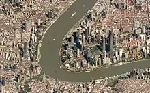
 A view of the Huangpu River as it flows through downtown Shanghai. | |
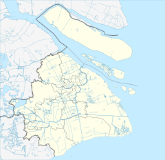 Location of mouth in Shanghai | |
| Native name | 黄浦江 (Chinese) |
| Location | |
| Country | China |
| Municipality | Shanghai |
| Physical characteristics | |
| Source | Dianshan Lake |
| • location | Qingpu, Shanghai, China |
| Mouth | Yangtze River |
• location | Baoshan, Shanghai, China |
• coordinates | 31°23′33″N 121°30′54″E |
| Length | 113 km (70 mi) |
| Discharge | |
| • average | 180 m3/s (6,400 cu ft/s)[1] |
| Basin features | |
| Tributaries | |
| • left | Suzhou Creek |
| Huangpu River | |||||||||||||
|---|---|---|---|---|---|---|---|---|---|---|---|---|---|
| Simplified Chinese | 黄浦江 | ||||||||||||
| Traditional Chinese | 黃浦江 | ||||||||||||
| Postal | Whangpoo River | ||||||||||||
| |||||||||||||
The Huangpu is the biggest river in central Shanghai, with the Suzhou Creek being its major tributary. It is on average 400 m (1,312 ft) wide and 9 m (30 ft) deep, and divides the city into two regions: Puxi ("west of Huangpu"), the traditional city center, and Pudong ("east of Huangpu").[3]
Bridges
- Fengpu Bridge
- Lupu Bridge, opened 2003.
- Minpu Bridge
- Minpu Bridge No. 2
- The lower deck of this bridge carries Line 5 across the Huangpu River. This is the first line of the Shanghai Metro to cross the river via a bridge.[4]
- Nanpu Bridge, opened 1991.
- Songpu Bridge, opened 1975 railway, 1976 highway.
- Songpu Bridge No. 2
- Songpu Bridge No. 3
- Xupu Bridge, opened 1997.
- Yangpu Bridge, opened 1993.
The following roadways, highways, and railways also cross the Huangpu River via a bridge:
- G1503 Shanghai Ring Expressway
- G50 Shanghai–Chongqing Expressway
- G60 Shanghai–Kunming Expressway
- Zhufeng Highway
- Huqingping Highway
- Shanghai–Hangzhou railway
Tunnels
A number lines of the Shanghai Metro cross underneath the river, including Line 12, Line 4, Line 2, Line 9, Line 4 (twice), Line 8, Line 13, and Line 11 (from north to south geographically).
There are several roadways which cross the Huangpu river via a tunnel, including:
- Bund Sightseeing Tunnel
- Dalian Road tunnel
- Dapu Road tunnel
- East Fuxing Road tunnel
- East Yan'an Road tunnel
- Jiangpu Road tunnel (planned)
- Jungong Road tunnel
- Longyao Road tunnel
- Lujiabang Road tunnel (planned)
- Luoxiu Road tunnel (planned)
- Nenjiang Road tunnel (planned)
- Outer Ring Road tunnel
- Renmin Road tunnel
- Shangzhong Road tunnel
- South Hongmei Road tunnel
- South Wanping Road tunnel (planned)
- South Xizang Road tunnel
- West Changjiang Road tunnel (under construction)
- Xiangyin Road tunnel
- Xinjian Road tunnel
- Yinxing Road tunnel (planned)
- Zhoujiazui Road tunnel (planned)
Ferries

There are currently several ferry lines operated by Shanghai Ferry. Numerous tour boats also ply the harbour in the Pudong area.
See also
- Geography of China
- List of rivers in China
References
Citations
- (四)水文 Archived 2011-09-29 at the Wayback Machine (in Chinese)
- Sladen (1895), p. 278.
- "The New Huangpu River Both Banks". Archived from the original on 2014-04-13. Retrieved Apr 16, 2014.
- "Shanghai Metro Line 5 South Extension to Start Test Runs". that's Shanghai. 10 August 2018. Retrieved 15 June 2020.
General and cited references
- Sladen, Douglas (1895), "Bits of China", The Japs at Home (5th ed.), New York: New Amsterdam Book Co., pp. 276–354
External links
 Media related to Huangpu River at Wikimedia Commons