Demirköy District
Demirköy District is a district of the Kırklareli Province of Turkey. Its seat is the town of Demirköy at the Istranca/Yildiz Mountains at the foot of the Mahya Dağı.[1] Its area is 893 km2,[2] and its population is 8,961 (2022).[3]. The population of different Background merged together, and are now called simple Hill people (Dağlılar). Some Pictures of the Villages[4]
Demirköy District | |
|---|---|
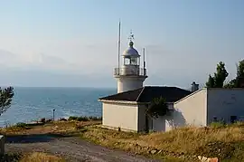 Limanköy Lighthouse | |
 Map showing Demirköy District in Kırklareli Province | |
 Demirköy District Location in Turkey  Demirköy District Demirköy District (Marmara) | |
| Coordinates: 41°49′N 27°46′E | |
| Country | Turkey |
| Province | Kırklareli |
| Seat | Demirköy |
| Government | |
| • Kaymakam | Yaşar Şimşek |
| Area | 893 km2 (345 sq mi) |
| Population (2022) | 8,961 |
| • Density | 10/km2 (26/sq mi) |
| Time zone | TRT (UTC+3) |
| Website | www |
Demirköy Mountains
- Mahya Dağı (1031 m) is the Highest mountain, followed by[5]:
- Karamanbayır Tepesi (995 m)
- Boyunduruk Tepesi (973 m)
- Fatmakaya Tepesi (901 m)
- Kaynak Tepesi (898 m)
- Paraşüt Tepesi (883 m)
- Meşe Tepesi (872 m)
- Haydut Tepesi (860 m)
- Sivritepe (851 m)
- Kaletepe (846 m)
- Bıçkı Tepesi (726 m)
- Çavuştepe (726 m)
- Dalyantepe (725 m)
- Karakoltepe (719 m)
- Bocalar Tepe (680 m)
- Ceviz Tepe (675 m)
- Yangınkulesi Tepe (629 m)
- Yeltepe (618 m)
- Topkoru Tepe (592 m)
- Soğuksu Tepesi (567 m)
- Büyükbezirgan Tepe (412 m)
- Kocataş Tepesi (281 m)
- Koca Tepe (207 m)
Composition
There are two municipalities in Demirköy District:[1][6]
- Demirköy (residents mainly the descendants of Pomaks from Mavrochori, Drama/(Tisovo) in Greece[7]
- İğneada
There are 15 villages[8] in Demirköy District:[9]
- Armutveren (Pomaks residents descendants from Bulgaria and Greece)[10]
- Avcılar (Gajal inhabitants) [11]
- Balaban (descendants of Bulgarian Turks residents)[12]
- Beğendik (residents descendants of Balkan Turks)[13]
- Boztaş (Pomaks residents descendants from Bulgaria and Greece)[14]
- Gökyaka (Bosniaks residents descendants[15]
- Hamdibey (residents offspring of mixed origin from Albanians and Bosniaks[16])
- İncesırt (Pomaks residents descendants[17]
- Karacadağ (Bosniaks residents descendants[18]
- Limanköy (residents descendants of Bulgarian Turks[19]
- Sarpdere (residents descendants of Pomaks)[20]
- Sislioba (residents descendants of Pomaks)[21]
- Sivriler (residents descendants of Bulgarian Turks[22]
- Yeşilce (residents descendants of Romanian Muslims[23]
- Yiğitbaşı (Majority residents offspring of mixed origin from Albanians and few Pomaks)[24]
- Karanlık (Pomaks residents descendants),[25] possible abandoned village, because in 2011 only two persons an old couple lived there.[26]
- Longoz (An abandoned village, yet in the İğneada Floodplain Forests National Park[27][28]
- Polohor (An abandoned village)[29]
- Macara ((An abandoned village)[30]
References
- İlçe Belediyesi, Turkey Civil Administration Departments Inventory. Retrieved 1 March 2023.
- "İl ve İlçe Yüz ölçümleri". General Directorate of Mapping. Retrieved 1 March 2023.
- "Address-based population registration system (ADNKS) results dated 31 December 2022, Favorite Reports" (XLS). TÜİK. Retrieved 13 March 2023.
- https://www.koylerim.com/kirklareli-demkirkoy-364gk.htm
- https://peakvisor.com/adm/demirkoey.html
- Belde Belediyesi, Turkey Civil Administration Departments Inventory. Retrieved 1 March 2023.
- https://nisanyanmap.com/?yer=35643&haritasi=demirk%C3%B6y
- https://www.trakyanet.com/rumeli/haberler/187-trakya/kirklareli/demirkoy/koyler.html
- Köy, Turkey Civil Administration Departments Inventory. Retrieved 1 March 2023.
- https://nisanyanmap.com/?yer=20471&haritasi=armutveren
- https://nisanyanmap.com/?yer=20466&haritasi=avc%C4%B1lar
- https://nisanyanmap.com/?yer=20472&haritasi=balaban
- https://nisanyanmap.com/?yer=20467&haritasi=be%C4%9Fendik
- https://nisanyanmap.com/?yer=20473&haritasi=bozta%C5%9F
- https://nisanyanmap.com/?yer=20474&haritasi=g%C3%B6kyaka
- https://nisanyanmap.com/?yer=20475&haritasi=hamdibey
- https://nisanyanmap.com/?yer=20476&haritasi=i%CC%87nces%C4%B1rt
- https://nisanyanmap.com/?yer=20477&haritasi=karacada%C4%9F
- https://nisanyanmap.com/?yer=20469&haritasi=limank%C3%B6y
- https://nisanyanmap.com/?yer=20478&haritasi=sarpdere
- https://nisanyanmap.com/?yer=20470&haritasi=sislioba
- https://nisanyanmap.com/?yer=20479&haritasi=sivriler
- https://nisanyanmap.com/?yer=20480&haritasi=ye%C5%9Filce
- https://nisanyanmap.com/?yer=20481&haritasi=yi%C4%9Fitba%C5%9F%C4%B1
- https://nisanyanmap.com/?yer=39623&haritasi=karanl%C4%B1kk%C3%B6y
- https://www.trakyagezi.com/karanlik-koyunun-son-asiklari/
- https://nisanyanmap.com/?yer=49005&haritasi=longoz
- https://www.igneada.bel.tr/galeri/longoz-ormanlari-milli-parki/2/
- https://nisanyanmap.com/?yer=60544&haritasi=polihor
- https://nisanyanmap.com/?yer=60543&haritasi=macara
Demirköy District in Kırklareli Province of Turkey | |||||||||||||||||||||||||||
|---|---|---|---|---|---|---|---|---|---|---|---|---|---|---|---|---|---|---|---|---|---|---|---|---|---|---|---|
| Districts |  Districts of Kırklareli | ||||||||||||||||||||||||||
| |||||||||||||||||||||||||||
Metropolitan municipalities are bolded. | |||||||||||||||||||||||||||
| Municipalities | |
|---|---|
| Villages |
|
This article is issued from Wikipedia. The text is licensed under Creative Commons - Attribution - Sharealike. Additional terms may apply for the media files.