Horní Kamenice
Horní Kamenice is a municipality and village in Plzeň-South District in the Plzeň Region of the Czech Republic. It has about 300 inhabitants.
Horní Kamenice | |
|---|---|
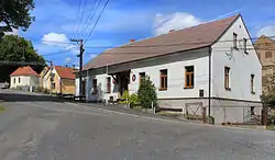 Municipal office and chapel (left) | |
 Flag .svg.png.webp) Coat of arms | |
 Horní Kamenice Location in the Czech Republic | |
| Coordinates: 49°34′11″N 13°6′4″E | |
| Country | |
| Region | Plzeň |
| District | Plzeň-South |
| First mentioned | 1115 |
| Area | |
| • Total | 3.85 km2 (1.49 sq mi) |
| Elevation | 377 m (1,237 ft) |
| Population (2022-01-01)[1] | |
| • Total | 256 |
| • Density | 66/km2 (170/sq mi) |
| Time zone | UTC+1 (CET) |
| • Summer (DST) | UTC+2 (CEST) |
| Postal code | 345 62 |
| Website | hornikamenice |
Geography
Horní Kamenice is located about 26 km (16 mi) southwest of Plzeň. It lies on the border of the Švihov Uplands and Plasy Uplands. Horní Kamenice is located in the valley of the river Radbuza. The Srbický Creek flows through the municipality.
History
The first written mention of Horní Kamenice is from 1115.[2]
From 1 January 2021, Horní Kamenice is no longer a part of Domažlice District and belongs to Plzeň-South District.[3]
Gallery
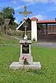 Crucifix in Horní Kamenice
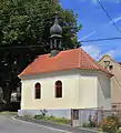 Chapel in Horní Kamenice
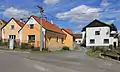 Village view
References
- "Population of Municipalities – 1 January 2022". Czech Statistical Office. 2022-04-29.
- "Souhrné informace" (in Czech). Obec Horní Kamenice. Retrieved 2021-05-24.
- "Obecně o novém zákonu č. 51/2020 Sb". mvcr.cz (in Czech). Ministry of the interior of the Czech Republic. Retrieved 2021-05-24.
This article is issued from Wikipedia. The text is licensed under Creative Commons - Attribution - Sharealike. Additional terms may apply for the media files.