Plzeň-South District
Plzeň-South District (Czech: okres Plzeň-jih) is a district in the Plzeň Region of the Czech Republic. Its capital is the city of Plzeň. The most populated town of the district is Přeštice.
Plzeň-South District
Okres Plzeň-jih | |
|---|---|
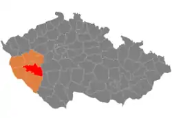 Location in the Plzeň Region within the Czech Republic | |
| Coordinates: 49°34′N 13°26′E | |
| Country | |
| Region | Plzeň |
| Capital | Plzeň |
| Area | |
| • Total | 1,068.23 km2 (412.45 sq mi) |
| Population (2022)[2] | |
| • Total | 68,918 |
| • Density | 65/km2 (170/sq mi) |
| Time zone | UTC+1 (CET) |
| • Summer (DST) | UTC+2 (CEST) |
| Municipalities | 99 |
| * Towns | 8 |
| * Market towns | 1 |
Administrative division
Plzeň-South District is divided into four administrative districts of municipalities with extended competence: Blovice, Nepomuk, Přeštice and Stod.
List of municipalities
Towns are marked in bold and market towns in italics:
Blovice - Bolkov - Borovno - Borovy - Buková - Bukovec - Čečovice - Černovice - Chlum - Chlumčany - Chlumy - Chocenice - Chotěšov - Čižice - Čížkov - Čmelíny - Dnešice - Dobřany - Dolce - Dolní Lukavice - Drahkov - Holýšov - Honezovice - Horní Kamenice - Horní Lukavice - Horšice - Hradec - Hradiště - Jarov - Kasejovice - Kbel - Klášter - Kotovice - Kozlovice - Kramolín - Kvíčovice - Letiny - Lisov - Líšina - Louňová - Lužany - Měcholupy - Merklín - Mileč - Milínov - Míšov - Mladý Smolivec - Mohelnice - Nebílovy - Nekvasovy - Nepomuk - Netunice - Neuměř - Neurazy - Nezdice - Nezdřev - Nová Ves - Nové Mitrovice - Oplot - Oselce - Otěšice - Polánka - Prádlo - Předenice - Přestavlky - Přeštice - Příchovice - Ptenín - Radkovice - Roupov - Řenče - Seč - Sedliště - Skašov - Soběkury - Spálené Poříčí - Srby - Štěnovice - Štichov - Stod - Střelice - Střížovice - Tojice - Třebčice - Týniště - Únětice - Útušice - Ves Touškov - Vlčí - Vlčtejn - Vrčeň - Všekary - Vstiš - Zdemyslice - Zemětice - Žákava - Ždírec - Žinkovy - Životice
Geography

The terrain is hilly, most of the territory has the character of highlands. The territory extends into four geomorphological mesoregions: Švihov Highlands (most of the territory), Plasy Uplands (west and northwest), Blatná Uplands (southeast) and Brdy Highlands (northeast). The highest point of the district is the mountain Nad Marastkem in Čížkov with an elevation of 805 m (2,641 ft), the lowest point is the river bed of the Radbuza in Dobřany at 317 m (1,040 ft).
The territory is rich in watercourses. There are three important rivers that cross the district from south to north: Radbuza, Úhlava and Úslava. There are no significant bodies of water.
Brdy is the protected landscape area that extends into the territory in the east.
Demographics
|
|
| ||||||||||||||||||||||||||||||||||||||||||||||||||||||
| Source: Censuses[3][4][5][lower-alpha 1] | ||||||||||||||||||||||||||||||||||||||||||||||||||||||||
Economy
The largest employers with its headquarters in Plzeň-South District and at least 500 employers are:[6]
| Economic entity | Location | Number of employees | Activity |
|---|---|---|---|
| MD Elektronik | Chotěšov | 2,000–2,499 | Manufacture of electrical equipment |
| International Automotive Components Group | Přeštice | 2,000–2,499 | Automotive industry |
| Dobřany Psychiatric Hospital | Dobřany | 1,000–1,499 | Health care |
| Vishay Electronic | Přeštice | 1,000–1,499 | Manufacture of electrical equipment |
| Murr CZ | Stod | 1,000–1,499 | Manufacture of electrical equipment |
| Stod Hospital | Stod | 500–999 | Health care |
Transport
The D5 motorway (part of the European route E50) from Prague to Plzeň and the Czech-German border briefly passes through the district. The other important roads in the district are the I/27 (part of European route E53) from Plzeň to the Czech-German border via Klatovy, and the I/20 (part of European route E49) from Karlovy Vary to Plzeň and Písek.
Sights
._(006).jpg.webp)
The most important monuments in the district, protected as national cultural monuments, are:[7]
- Church of Saint Nicholas in Čečovice
- Church of the Assumption of the Virgin Mary in Přeštice
- Chotěšov Abbey
The best-preserved settlements, protected as monument zones, are:[8]
The most visited tourist destination is the Chotěšov Abbey.[9]
Notes
References
- "Small Lexicon of Municipalities of the Czech Republic – 2022". Czech Statistical Office. 2022-12-15.
- "Population of Municipalities – 1 January 2022". Czech Statistical Office. 2022-04-29.
- "Historický lexikon obcí České republiky 1869–2011 – Okres Plzeň-jih" (in Czech). Czech Statistical Office. 2015-12-21. pp. 11–12.
- "Historický lexikon obcí České republiky 1869–2011 – Okres Domažlice" (in Czech). Czech Statistical Office. 2015-12-21. pp. 1–2.
- "Population Census 2021: Population by sex". Public Database. Czech Statistical Office. 2021-03-27.
- "Registr ekonomických subjektů". Business Register (in Czech). Czech Statistical Office. Retrieved 2023-02-20.
- "Výsledky vyhledávání: Národní kulturní památky, okres Plzeň-jih". Ústřední seznam kulturních památek (in Czech). National Heritage Institute. Retrieved 2023-02-20.
- "Výsledky vyhledávání: Památkové rezervace, Památkové zóny, okres Plzeň-jih". Ústřední seznam kulturních památek (in Czech). National Heritage Institute. Retrieved 2023-02-20.
- "Návštěvnost památek 2021" (in Czech). Národní informační a poradenské středisko pro kulturu. Retrieved 2023-02-20.
External links
- Plzeň-South District profile on the Czech Statistical Office's website