Horní Pěna
Horní Pěna (German: Oberbaumgarten) is a municipality and village in Jindřichův Hradec District in the South Bohemian Region of the Czech Republic. It has about 600 inhabitants. The village of Malíkov nad Nežárkou within the municipality is well preserved and is protected by law as a village monument zone.
Horní Pěna | |
|---|---|
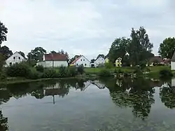 Malíkov nad Nežárkou, a part of Horní Pěna | |
 Flag  Coat of arms | |
 Horní Pěna Location in the Czech Republic | |
| Coordinates: 49°6′16″N 15°2′32″E | |
| Country | |
| Region | South Bohemian |
| District | Jindřichův Hradec |
| First mentioned | 1354 |
| Area | |
| • Total | 14.85 km2 (5.73 sq mi) |
| Elevation | 496 m (1,627 ft) |
| Population (2022-01-01)[1] | |
| • Total | 574 |
| • Density | 39/km2 (100/sq mi) |
| Time zone | UTC+1 (CET) |
| • Summer (DST) | UTC+2 (CEST) |
| Postal codes | 377 01, 378 31 |
| Website | www |
Administrative parts
The village of Malíkov nad Nežárkou is an administrative part of Horní Pěna.
Geography
Horní Pěna is located about 5 kilometres (3 mi) south of Jindřichův Hradec and 42 km (26 mi) northeast of České Budějovice. It lies in the Javořice Highlands. The highest point is at 596 metres (1,955 ft) above sea level. In addition to several small fishponds, there is Pěněnský Pond with an area of 75 ha (190 acres).[2]
History
The first written mention of Horní Pěna is from 1354.[3]
Sights
In Horní Pěna is the Zoo Na Hrádečku, a small zoo with more than 100 species on an area of 10 hectares (25 acres).[4]
References
- "Population of Municipalities – 1 January 2022". Czech Statistical Office. 2022-04-29.
- "Ohlasy od Dřeva 3/2011" (in Czech). Obec Horní Pěna. p. 2. Retrieved 2022-08-29.
- "Horní Pěna" (in Czech). Obec Horní Pěna. Retrieved 2021-09-03.
- "Zoo Na Hrádečku" (in Czech). Zoo Na Hrádečku. Retrieved 2021-09-22.