Staré Město pod Landštejnem
Staré Město pod Landštejnem (German: Altstadt) is a market town in Jindřichův Hradec District in the South Bohemian Region of the Czech Republic. It has about 500 inhabitants.
Staré Město pod Landštejnem | |
|---|---|
 Centre of Staré Město pod Landštejnem | |
 Flag 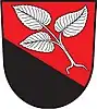 Coat of arms | |
 Staré Město pod Landštejnem Location in the Czech Republic | |
| Coordinates: 49°0′12″N 15°15′15″E | |
| Country | |
| Region | South Bohemian |
| District | Jindřichův Hradec |
| First mentioned | 1495 |
| Area | |
| • Total | 69.25 km2 (26.74 sq mi) |
| Elevation | 545 m (1,788 ft) |
| Population (2022-01-01)[1] | |
| • Total | 456 |
| • Density | 6.6/km2 (17/sq mi) |
| Time zone | UTC+1 (CET) |
| • Summer (DST) | UTC+2 (CEST) |
| Postal codes | 378 81, 378 82 |
| Website | www |
Administrative parts
Villages and hamlets of Dobrotín, Landštejn, Návary, Podlesí, Pomezí, Veclov and Vitíněves are administrative parts of Staré Město pod Landštejnem.
Geography
Staré Město pod Landštejnem is located about 23 kilometres (14 mi) southeast of Jindřichův Hradec and 55 km (34 mi) east of České Budějovice. The municipal territory borders with Austria and is adjacent to the municipality of Kautzen. It is situated in the Javořice Highlands. The highest point is the hill Uhliště at 702 metres (2,303 ft) above sea level. The Pstruhovec stream flows through the market town.
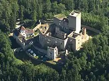
Sights
The main landmark is the Landštejn Castle.
Twin towns – sister cities
Staré Město pod Landštejnem is twinned with:[2]
 Rača (Bratislava), Slovakia
References
- "Population of Municipalities – 1 January 2022". Czech Statistical Office. 2022-04-29.
- "Podpis partnerské smlouvy s Račou" (in Czech). Městys Staré Město pod Landštejnem. Retrieved 2021-01-08.