Portal:Myanmar
ကြိုဆိုပါတယ်။ / Welcome to the Myanmar Portal 

Myanmar, officially the Republic of the Union of Myanmar, also known as Burma (the official name until 1989), is a country in Southeast Asia. It is the largest country by area in Mainland Southeast Asia, and had a population of about 54 million in 2017. It is bordered by Bangladesh and India to its northwest, China to its northeast, Laos and Thailand to its east and southeast, and the Andaman Sea and the Bay of Bengal to its south and southwest. The country's capital city is Naypyidaw, and its largest city is Yangon (formerly Rangoon).
Myanmar is a member of the East Asia Summit, Non-Aligned Movement, ASEAN, and BIMSTEC, but it is not a member of the Commonwealth of Nations despite once being part of the British Empire. The country is very rich in natural resources, such as jade, gems, oil, natural gas, teak and other minerals, as well as also endowed with renewable energy, having the highest solar power potential compared to other countries of the Great Mekong Subregion. However, Myanmar has long suffered from instability, factional violence, corruption, poor infrastructure, as well as a long history of colonial exploitation with little regard to human development. In 2013, its GDP (nominal) stood at US$56.7 billion and its GDP (PPP) at US$221.5 billion. The income gap in Myanmar is among the widest in the world, as a large proportion of the economy is controlled by cronies of the military junta. Myanmar is one of the least developed countries; as of 2020, according to the Human Development Index, it ranks 147 out of 189 countries in terms of human development. Since 2021, more than 600,000 people were displaced across Myanmar due to the surge in violence post-coup, with more than 3 million people in dire need of humanitarian assistance. (Full article...)
Selected articles -
![Image 1Burmese nat statues in the shrineThe nats (နတ်; MLCTS: nat; IPA: [naʔ]) are god-like spirits venerated in Myanmar and neighbouring countries in conjunction with Buddhism. They are divided between the 37 Great Nats who were designated that status by King Anawrahta when he formalized the official list of nats. Most of the 37 Great Nats were human beings who met violent deaths.There are two types of nats in Burmese Belief: nat sein (နတ်စိမ်း) which are humans that were deified after their deaths and all the other nats which are spirits of nature (spirits of water, trees etc.). (Full article...)](../I/Blank.png.webp)
 Burmese nat statues in the shrine
The nats (နတ်; MLCTS: nat; IPA: [naʔ]) are god-like spirits venerated in Myanmar and neighbouring countries in conjunction with Buddhism. They are divided between the 37 Great Nats who were designated that status by King Anawrahta when he formalized the official list of nats. Most of the 37 Great Nats were human beings who met violent deaths.
There are two types of nats in Burmese Belief: nat sein (နတ်စိမ်း) which are humans that were deified after their deaths and all the other nats which are spirits of nature (spirits of water, trees etc.). (Full article...)
General elections were held in Myanmar on 7 November 2010, in accordance with the new constitution, which was approved in a referendum held in May 2008. The election date was announced by the State Peace and Development Council (SPDC) on 13 August.
The elections were the fifth step of the seven-step "roadmap to democracy" proposed by the SPDC in 2003, the sixth and seventh steps being the convening of elected representatives and the building of a modern, democratic nation, respectively. However, the National League for Democracy boycotted the elections. The result was a sweeping victory for the Union Solidarity and Development Party, which won nearly 80% of seats contested across the upper and lower houses. The United Nations expressed concern about the fairness of the elections, and western countries dismissed them as fraudulent. (Full article...).png.webp) Sites of battles (1277–1287)
Sites of battles (1277–1287)
Pagan might have also seen a battle in 1287
The first Mongol invasions of Burma (Myanmar) (Burmese: မွန်ဂို–မြန်မာ စစ် (၁၂၇၇–၁၂၈၇); Chinese: 元緬戰爭) were a series of military conflicts between Kublai Khan's Yuan dynasty, a division of the Mongol Empire, and the Pagan Empire took place between 1277 and 1287. The invasions toppled the 250-year-old Pagan Empire, and the Mongol army seized Pagan territories in present-day Dehong, Yunnan and northern Burma to Tagaung. The invasions ushered in 250 years of political fragmentation in Burma and the rise of ethnic Tai-Shan states throughout mainland Southeast Asia.
The Mongols first demanded tribute from Pagan in 1271–72, as part of their drive to encircle the Song dynasty of China. When King Narathihapate refused, Emperor Kublai Khan himself sent another mission in 1273, again demanding tribute. It too was rejected. In 1275, the emperor ordered the Yunnan government to secure the borderlands in order to block an escape path for the Song, and permitted a limited border war if Pagan contested. Pagan did contest but its army was driven back at the frontier by the Mongol Army in 1277–78. After a brief lull, Kublai Khan in 1281 turned his attention to Southeast Asia, demanding tribute from Pagan, the Khmer Empire, Đại Việt and Champa. When the Burmese king again refused, the emperor ordered an invasion of northern Burma. Two dry season campaigns (1283–1285) later, the Mongols had occupied down to Tagaung and Hanlin, forcing the Burmese king to flee to Lower Burma. The Mongols organized northern Burma as the province of Zhengmian. (Full article...)
China–Myanmar relations (Chinese: 中缅关系; Burmese: တရုတ်မြန်မာဆက်ဆံရေး) are the international relations between the People's Republic of China and Myanmar. China and Myanmar have active bilateral relations with each other. The relation is often described as a pauk-phaw relationship (Burmese: ပေါက်ဖော်), based a Burmese term for kinsfolk that implicates special asymmetric obligations between the two countries.
Bilateral relations between China and Myanmar have faced difficulties due to the effects of alleged Chinese-sponsored debt-traps and Chinese-backed rebels in northern Myanmar territories. In recent years, the relations between China and Myanmar have faced some problems due to ongoing clashes between ethnic Chinese rebels and the Myanmar military near the China–Myanmar border. However, China remains Myanmar's largest trading partner and the dependence of Myanmar on China has grown after the 2021 Myanmar coup d'état, which led to the near international isolation of the country. (Full article...).svg.png.webp)
British rule in Burma lasted from 1824 to 1948, from the successive three Anglo-Burmese wars through the creation of Burma as a province of British India to the establishment of an independently administered colony, and finally independence. The region under British control was known as British Burma, and officially known as Burma (Burmese: မြန်မာနိုင်ငံတော်) from 1886. Various portions of Burmese territories, including Arakan and Tenasserim were annexed by the British after their victory in the First Anglo-Burmese War; Lower Burma was annexed in 1852 after the Second Anglo-Burmese War. The annexed territories were designated the minor province (a chief commissionership) of British India in 1862.
After the Third Anglo-Burmese War in 1885, Upper Burma was annexed, and the following year, the province of Burma in British India was created, becoming a major province (a lieutenant-governorship) in 1897. This arrangement lasted until 1937, when Burma began to be administered separately by the Burma Office under the Secretary of State for India and Burma. British rule was disrupted during the Japanese occupation of much of the country during World War II. Burma achieved independence from British rule on 4 January 1948. (Full article...)
Yangon Circular Railway (Burmese: ရန်ကုန် မြို့ပတ် ရထား [jàɰ̃ɡòʊɰ̃ mjo̰baʔ jətʰá]) is the local commuter rail network that serves the Yangon metropolitan area. Operated by Myanma Railways, the 45.9-kilometre (28.5 mi) 39-station loop system connects satellite towns and suburban areas to the city. Circa 2008–2010, the railway had about 200 coaches, had 20 daily runs, and sold 100,000 to 150,000 tickets daily.
The railway is heavily utilized by lower-income commuters, as it is (along with buses) the cheapest method of transportation in Yangon.
The hours of service have been consistent over the years, from 3:45 am to 10:15 pm daily. In 2011, the cost of a ticket for a distance of 15 miles was two hundred kyats (~eighteen US cents), and that for over 15 miles was four hundred kyats (~37 US cents). In the new currency (introduced in 2012) long distance tickets are 200 kyat (~20 US cents). (Full article...) Location of airport in Myanmar
Mandalay International Airport (Burmese: မန္တလေး အပြည်ပြည်ဆိုင်ရာ လေဆိပ်; (IATA: MDL, ICAO: VYMD)), located 35 km south of Mandalay in Tada-U, is one of three international airports in Myanmar. Completed in 1999, it was the largest and most modern airport in the country until the modernization of Yangon International Airport in 2008. The airport connects 11 domestic and seven international destinations. Its 4,267 m (13,999 ft) runway is the longest runway in use in Southeast Asia and has the capacity to handle up to 3 million passengers a year. (Full article...)
The Shwezigon Pagoda or Shwezigon Paya (ရွှေစည်းခုံဘုရား [ɕwèzíɡòʊɰ̃ pʰəjá]) is a Buddhist stupa located in Nyaung-U, Myanmar. A prototype of Burmese stupas, it consists of a circular gold leaf-gilded stupa surrounded by smaller temples and shrines. Construction of the Shwezigon Pagoda began during the reign of King Anawrahta (r. 1044–1077), the founder of the Pagan Empire, in 1059–1060 and was completed in 1102, during the reign of his son King Kyansittha. Over the centuries the pagoda had been damaged by many earthquakes and other natural calamities, and has been refurbished several times. In recent renovations it has been covered by more than 30,000 copper plates. However, the lowest level terraces have remained as they were.
This pagoda, a sacred Buddhist religious place, is believed to enshrine a bone and tooth of Gautama Buddha. The pagoda is in the form of a cone formed by five square terraces with a central solid core. There are footprints below the four standing Buddha statues here. Jataka legends are depicted on glazed terra-cotta tiles set into three rectangular terraces. At the entrance of the pagoda there are large statues of guardians of the temple. There are also four bronze standing statues of Buddha which are stated to be of the current age Buddha. At the outer limits of the pagoda there are 37 nats deified along with an intricately carved wooden sculpture of Thagyamin, Burmese version of Indian god Indra. Within the compound of the Shwezigon Pagoda there is a stone pillar containing Mon language inscriptions dedicated by Kyansittha. (Full article...)- Hkakaborazi National Park is a national park in northern Myanmar with an area of 3,812.46 km2 (1,472.00 sq mi). It was established in 1998.
It surrounds Hkakabo Razi, the highest mountain in the country.
It ranges in elevation from 900 to 5,710 metres (2,950 to 18,730 ft) comprising evergreen forest and mixed deciduous forests in Nogmung Township, Kachin State. It is managed by the Nature and Wildlife Conservation Division.
It is contiguous with Bumhpa Bum Wildlife Sanctuary and Hukaung Valley Wildlife Sanctuary. These protected areas together with Hponkanrazi Wildlife Sanctuary comprise the largest continuous expanse of natural forest called the Northern Forest Complex stretching over an area of 30,105 km2 (11,624 sq mi). Its objective is to conserve the biodiversity of the Ayeyarwady and Chindwin river basins. (Full article...)
Did you know (auto-generated) -
- ... that the EMER-K1 was created by Myanmar by reverse-engineering QBZ-97 assault rifles sold to them?
- ... that the Myanmar Coast Guard was initially proposed as a civilian law enforcement agency before being established as a branch of the military three years later?
- ... that Esther Ze Naw, who appeared on the 2021 Time 100, was one of the few people in Myanmar who protested against Aung San Suu Kyi's defence of the military at the International Court of Justice in December 2019?
- ... that the mission of the United Nations special envoy on Myanmar has been called a "diplomatic graveyard"?
- ... that Rangoon kept its own time for more than two decades after Burma Standard Time first came into effect?
- ... that Maw Htun Aung, a Shan Nationalities League for Democracy candidate in the 2020 Myanmar general election, is Kachin, not Shan?
- ... that as part of the coronation of Mindon Min, the square yuzana around the capital was designated a sanctuary?
- ... that the Burmese and South Korean first ladies held their first informal conversation 44 years after the establishment of bilateral relations between the two countries?
Related portals and projects
![]() WikiProject Myanmar
WikiProject Myanmar
![]() WikiProject Southeast Asia
WikiProject Southeast Asia
![]() WikiProject Asia
WikiProject Asia
General images -
 Myinhkin thabin - equestrian sport (from Culture of Myanmar)

 The paddle steamer Ramapoora (right) of the British India Steam Navigation Company on the Rangoon river having just arrived from Moulmein. 1895. Photographers: Watts and Skeen (from History of Myanmar)
 A wide range of Burmese lacquerware from Bagan (from Culture of Myanmar)
 Boxing match. 19th-century watercolour (from Culture of Myanmar)
 Protesters in Yangon carrying signs reading "Free Daw Aung San Suu Kyi" on 8 February 2021. (from History of Myanmar)
 Myanmar (Burma) map of Köppen climate classification (from Geography of Myanmar)
_headquarter.jpg.webp) Aung San Suu Kyi addresses crowds at the NLD headquarters shortly after her release. (from History of Myanmar)
Aung San Suu Kyi addresses crowds at the NLD headquarters shortly after her release. (from History of Myanmar) A theatrical performance of the Mon dance (from Culture of Myanmar)
 19th century funeral cart and spire, which would form part of the procession from the home to the place of cremation (from Culture of Myanmar)
 Two female musicians play the saung at a performance in Mandalay. (from Culture of Myanmar)
 Sculpture of Myanmar mythical lion (from Culture of Myanmar)
 A wedding procession, with the groom and bride dressed in traditional Burmese wedding clothes, reminiscent of royal attire. (from Culture of Myanmar)
 Hlei pyaingbwè - a Burmese regatta (from Culture of Myanmar)
 British soldiers dismantling cannons belonging to King Thibaw's forces, Third Anglo-Burmese War, Ava, 27 November 1885. Photographer: Hooper, Willoughby Wallace (1837–1912). (from History of Myanmar)
 British soldiers remove their shoes at the entrance of Shwedagon Pagoda. To the left, a sign reads "Foot wearing is strictly prohibited" in Burmese, English, Tamil, and Urdu. (from Culture of Myanmar)
.jpg.webp) Salween river at Mae Sam Laep on the Thai-Myanmar border (from Geography of Myanmar)
Salween river at Mae Sam Laep on the Thai-Myanmar border (from Geography of Myanmar) Former US President Barack Obama poses barefoot on the grounds of Shwedagon Pagoda, one of Myanmar's major Buddhist pilgrimage sites. (from Culture of Myanmar)
 Protesters in Yangon with a banner that reads non-violence: national movement in Burmese, in the background is Shwedagon Pagoda. (from History of Myanmar)
 Temples at Mrauk U, was the capital of the Mrauk U Kingdom, which ruled over what is now Rakhine State. (from History of Myanmar)
 A group of Buddhist worshipers at Shwedagon Pagoda, an important religious site for Burmese Buddhists. (from Culture of Myanmar)
 Political Map of Burma (Myanmar) c. 1450 CE. (from History of Myanmar)
 The restored Taungoo or Nyaungyan dynasty c. 1650 CE. (from History of Myanmar)
 Recorder's Court on Sule Pagoda Road, with the Sule Pagoda at the far end, Rangoon, 1868. Photographer: J. Jackson. (from History of Myanmar)
 Jade Mine in Hpakant (from Geography of Myanmar)
 The shores of Irrawaddy River at Nyaung-U, Bagan (from Geography of Myanmar)
 Saint Mary's Cathedral in Downtown Yangon is the largest Roman Catholic cathedral in Burma. (from Culture of Myanmar)
 British soldiers on patrol in the ruins of the Burmese town of Bahe during the advance on Mandalay, January 1945. (from History of Myanmar)
 Grandfather Island, Dawei (from Geography of Myanmar)
 Mount Popa, a dormant volcano in the Central Lowlands (from Geography of Myanmar)
 A large fracture on the Mingun Pahtodawgyi caused by the 1839 Ava earthquake. (from Geography of Myanmar)
 A bull fight. 19th-century watercolour (from Culture of Myanmar)
 Mountains near Pindaya on the Shan Plateau (from Geography of Myanmar)
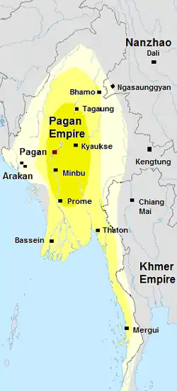 Pagan Kingdom during Narapatisithu's reign. Burmese chronicles also claim Kengtung and Chiang Mai. Core areas shown in darker yellow. Peripheral areas in light yellow. Pagan incorporated key ports of Lower Burma into its core administration by the 13th century. (from History of Myanmar)
 Aerial view of a burned Rohingya village in Rakhine state, Myanmar, September 2017 (from History of Myanmar)
 Vegetable stall on the roadside at the Madras Lancer Lines, Mandalay, January 1886. Photographer: Hooper, Willoughby Wallace (1837–1912). (from History of Myanmar)
Major topics
Categories
More topics

Associated Wikimedia
The following Wikimedia Foundation sister projects provide more on this subject:
-
 Commons
Free media repository -
 Wikibooks
Free textbooks and manuals -
 Wikidata
Free knowledge base -
 Wikinews
Free-content news -
 Wikiquote
Collection of quotations -
 Wikisource
Free-content library -
 Wikiversity
Free learning tools -
 Wikivoyage
Free travel guide -
 Wiktionary
Dictionary and thesaurus
More portals
-
 List of all portalsList of all portals
 -
 The arts portal
 -
 Biography portal
 -
 Current events portal
 -
 Geography portal
 -
 History portal
 -
 Mathematics portal
 -
 Science portal
 -
 Society portal
 -
 Technology portal
 -
 Random portalRandom portal
 -
 WikiProject PortalsWikiProject Portals