Cushing, Oklahoma
Cushing (Pawnee: Túhkiicahihtuʾ [3]) is a city in Payne County, Oklahoma, United States. The population was 7,826 at the 2010 census, a decline of 6.5 percent from 8,371 at the 2000 census.[4]
Cushing, Oklahoma | |
|---|---|
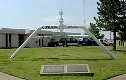 Pipeline Crossroads of the World monument, 2006 | |
| Nickname(s): "Pipeline Crossroads of the World" | |
| Motto(s): "Personal Connections. Global Impact." | |
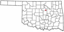 Location of Cushing, Oklahoma | |
| Coordinates: 35°58′57″N 96°45′51″W | |
| Country | United States |
| State | Oklahoma |
| County | Payne |
| Area | |
| • Total | 7.6 sq mi (19.8 km2) |
| • Land | 7.6 sq mi (19.8 km2) |
| • Water | 0.0 sq mi (0.0 km2) |
| Elevation | 935 ft (285 m) |
| Population (2010) | |
| • Total | 7,826 |
| • Density | 1,096.1/sq mi (423.2/km2) |
| Time zone | UTC-6 (Central (CST)) |
| • Summer (DST) | UTC-5 (CDT) |
| ZIP code | 74023 |
| Area code(s) | 539/918 |
| FIPS code | 40-18850[1] |
| GNIS feature ID | 1091897[2] |
References
- "American FactFinder". United States Census Bureau. Retrieved 2008-01-31.
- "US Board on Geographic Names". United States Geological Survey. 2007-10-25. Retrieved 2008-01-31.
- "AISRI Dictionary Database Search--prototype version. "River", Southband Pawnee". American Indian Studies Research Institute. Retrieved 2012-05-26.
- "CensusViewer:Population of the City of Cushing, Oklahoma". Archived from the original on 2013-06-15. Retrieved 2012-11-05.

Wikimedia Commons has media related to Cushing, Oklahoma.
This article is issued from Wikipedia. The text is licensed under Creative Commons - Attribution - Sharealike. Additional terms may apply for the media files.