Rorschwihr
Rorschwihr is a commune in the Haut-Rhin department east France. In 2015, 382 people lived there.
Rorschwihr | |
|---|---|
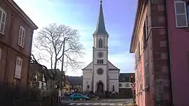 The church of Saint Michel at Rorschwihr | |
.svg.png.webp) Coat of arms | |
Location of Rorschwihr  | |
 Rorschwihr  Rorschwihr | |
| Coordinates: 48°13′05″N 7°21′49″E | |
| Country | France |
| Region | Grand Est |
| Department | Haut-Rhin |
| Arrondissement | Colmar-Ribeauvillé |
| Canton | Sainte-Marie-aux-Mines |
| Intercommunality | Pays de Ribeauvillé |
| Government | |
| • Mayor (2008–2014) | Olivier Stocky |
| Area 1 | 2.47 km2 (0.95 sq mi) |
| Population (2006) | 399 |
| • Density | 160/km2 (420/sq mi) |
| Time zone | UTC+01:00 (CET) |
| • Summer (DST) | UTC+02:00 (CEST) |
| INSEE/Postal code | 68285 /68590 |
| Elevation | 190–362 m (623–1,188 ft) |
| 1 French Land Register data, which excludes lakes, ponds, glaciers > 1 km2 (0.386 sq mi or 247 acres) and river estuaries. | |
Rorschwihr is at the bottom of Vosges Mountains, between Sélestat and Ribeauvillé.
Population
| 1962 | 1968 | 1975 | 1982 | 1990 | 1999 | 2006 |
|---|---|---|---|---|---|---|
| 248 | 264 | 272 | 303 | 350 | 366 | 386 |
Related pages
References
Other websites
![]() Media related to Rorschwihr at Wikimedia Commons
Media related to Rorschwihr at Wikimedia Commons
This article is issued from Wikipedia. The text is licensed under Creative Commons - Attribution - Sharealike. Additional terms may apply for the media files.