Rockville, Connecticut
Rockville is a census-designated place and a village of the town of Vernon in Tolland County, Connecticut, United States. The population was 7,474 at the 2010 census.
Rockville, Connecticut | |
|---|---|
 Downtown Rockville from Fox Hill in 2015 | |
| Etymology: "Going to the Rock" | |
 Location in Tolland County, then Tolland County's location in Connecticut | |
| Coordinates: 41.8673°N 72.4483°W | |
| Country | |
| State | |
| Town | Vernon |
| Area | |
| • Total | 5 km2 (1.8 sq mi) |
| • Land | 4.6 km2 (1.76 sq mi) |
| • Water | 0.1 km2 (0.04 sq mi) |
| Population (2010)[1] | |
| • Total | 7,474 |
| • Estimate (2018)[2] | 7,188 |
| • Density | 752.1/km2 (1,947.9/sq mi) |
| Time zone | UTC-5 (Eastern Time Zone) |
| • Summer (DST) | UTC-4 (Eastern Daylight Time) |
| Postal Code | 06066 |
| Area code(s) | 860 |
| Website | rockvillect |
Rockville Historic District | |
U.S. Historic district | |
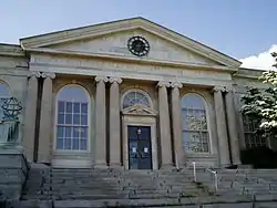 George Maxwell Memorial Library, photograph from 2006 | |
  | |
| Location | Roughly bounded by Snipsic St., Davis Ave., West and South Sts., Rockville, Connecticut |
| Coordinates | 41°51′51″N 72°27′4″W |
| Area | 550 acres (220 ha) |
| Architect | Platt, Charles A. et al |
| Architectural style | Greek Revival, Late Victorian, Classical Revival |
| NRHP reference No. | 84001173[3] |
| Added to NRHP | September 13, 1984 |
References
- Bureau, U.S. Census. "American FactFinder - Community Facts". factfinder.census.gov. Archived from the original on 2020-02-14. Retrieved 2016-12-01.
- Bureau, U.S. Census. "American FactFinder - Community Facts". factfinder.census.gov. Archived from the original on 2020-02-14. Retrieved 2016-12-01.
- "National Register Information System". National Register of Historic Places. National Park Service. 2009-03-13.
Municipalities and communities of Tolland County, Connecticut, United States | ||
|---|---|---|
| Towns |  | |
| CDPs | ||
| Other communities |
| |
This article is issued from Wikipedia. The text is licensed under Creative Commons - Attribution - Sharealike. Additional terms may apply for the media files.