25th meridian east

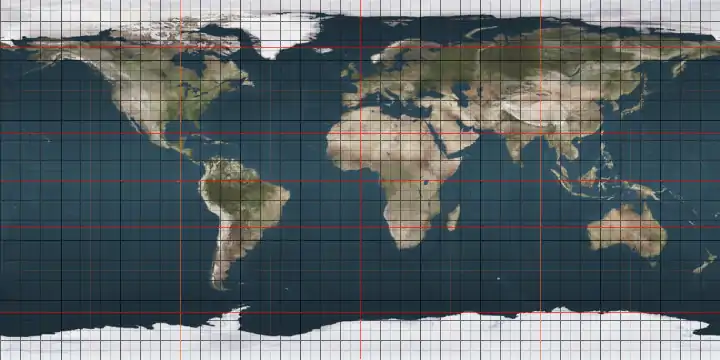
The meridian 25° east of Greenwich is a line of longitude that extends from the North Pole across the Arctic Ocean, Europe, Africa, the Indian Ocean, the Southern Ocean, and Antarctica to the South Pole.

Line across the Earth
25°
25th meridian east
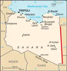
The 25th meridian east delineates most of Libya's eastern border with Egypt and Sudan

The 25th meridian east forms a great circle with the 155th meridian west.

Most of the border between Libya and Egypt is defined by the meridian, as is much of the border between Libya and Sudan.[1]

From Pole to Pole

Starting at the North Pole and heading south to the South Pole, the 25th meridian east passes through:

Co-ordinates Country, territory or sea Notes
90°0′N 25°0′E Arctic Ocean
80°15′N 25°0′E  Norway Island of Nordaustlandet, Svalbard
79°20′N 25°0′E Barents Sea
76°29′N 25°0′E  Norway Island of Hopen, Svalbard
76°26′N 25°0′E Barents Sea
71°2′N 25°0′E  Norway
68°37′N 25°0′E  Finland
65°38′N 25°0′E Baltic Sea Gulf of Bothnia
65°3′N 25°0′E  Finland Island of Hailuoto
65°2′N 25°0′E Baltic Sea Gulf of Bothnia
64°55′N 25°0′E  Finland Passing through Helsinki
60°10′N 25°0′E Baltic Sea Gulf of Finland
59°39′N 25°0′E  Estonia Island of Prangli
59°37′N 25°0′E Baltic Sea Gulf of Finland
59°29′N 25°0′E  Estonia Passing just east of Tallinn
58°0′N 25°0′E  Latvia
56°18′N 25°0′E  Lithuania Passing just west of Vilnius
54°9′N 25°0′E  Belarus
51°55′N 25°0′E  Ukraine Volyn Oblast — passing just west of Lutsk
Lviv Oblast — passing just east of Zolochiv
Ternopil Oblast — passing just east of Berezhany
Ivano-Frankivsk Oblast — passing through Kolomyia
Chernivtsi Oblast
47°44′N 25°0′E  Romania
43°44′N 25°0′E  Bulgaria
41°23′N 25°0′E  Greece
40°57′N 25°0′E Mediterranean Sea Aegean Sea - passing just west of the island of Lemnos,  Greece
39°33′N 25°0′E  Greece Island of Agios Efstratios
39°29′N 25°0′E Mediterranean Sea Aegean Sea
37°46′N 25°0′E  Greece Just passing through the easternmost point of the island of Andros
37°46′N 25°0′E Mediterranean Sea Aegean Sea
37°40′N 25°0′E  Greece Island of Tinos
37°38′N 25°0′E Mediterranean Sea Aegean Sea - passing just east of the island of Syros,  Greece
36°59′N 25°0′E  Greece Island of Despotiko
36°57′N 25°0′E Mediterranean Sea Aegean Sea
Passing between the islands of Folegandros and Sikinos,  Greece
36°36′N 25°0′E Mediterranean Sea Sea of Crete
35°25′N 25°0′E  Greece Island of Crete
34°56′N 25°0′E Mediterranean Sea
31°57′N 25°0′E  Libya
31°30′N 25°0′E  Egypt
30°50′N 25°0′E  Libya For about 12 km
30°44′N 25°0′E  Egypt
29°15′N 25°0′E  Libya /  Egypt border
22°0′N 25°0′E  Libya /  Sudan border
20°0′N 25°0′E  Sudan
9°58′N 25°0′E  South Sudan
7°58′N 25°0′E  Central African Republic
5°0′N 25°0′E  Democratic Republic of the Congo
11°15′S 25°0′E  Zambia
17°36′S 25°0′E  Namibia Caprivi Strip
17°43′S 25°0′E  Botswana Passing through the Makgadikgadi Pan
25°45′S 25°0′E  South Africa North West
Northern Cape - for about 8 km
North West
Northern Cape - for about 8 km
Free State
Northern Cape
Eastern Cape
33°59′S 25°0′E Indian Ocean
60°0′S 25°0′E Southern Ocean
70°7′S 25°0′E Antarctica Queen Maud Land, claimed by  Norway

See also

  • 24th meridian east
  • 26th meridian east

References

  1. Brownlie, Ian (1979). African Boundaries: A Legal and Diplomatic Encyclopedia. Institute for International Affairs, Hurst and Co. pp. 102–09 & 133–40.
This article is issued from Wikipedia. The text is licensed under Creative Commons - Attribution - Sharealike. Additional terms may apply for the media files.