Administrative divisions of Cape Verde
The territory of Cape Verde is divided into 22 concelhos (municipalities), and subdivided into 32 freguesias (equivalent to civil parish).
 |
|---|
In Portuguese language usage, there are two words to distinguish the territory and the administrative organ. Administratively, right below the government, there are the municípios (municipalities), which administer the concelhos. Therefore, the concelhos are the first-level administrative subdivision in Cape Verde. Each municipality has an Assembleia Municipal (municipal assembly, the legislative body) and a Câmara Municipal (municipal chamber, the executive body). Every four years elections are held for the Assembleia Municipal, the Câmara Municipal and the President of the Câmara Municipal. Where a municipality consists of several freguesias (civil parishes), a Delegação Municipal (municipal delegation) is established in the parishes that do not contain the municipal seat.[1]
The islands are traditionally divided in two geographic regions (with no administrative meaning):
- Barlavento Islands (windward), the six northern islands and
- Sotavento Islands (leeward), the four southern ones.
Municipalities and civil parishes
Island group: Barlavento Islands Sotavento Islands
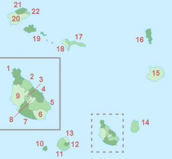
| Map # | Municipality | Island(s) | Area (km2)[2] | Population (2010 census)[2] | Population (2021 Census)[3] | Parishes |
|---|---|---|---|---|---|---|
| 1 | Tarrafal | Santiago | 120.8 | 18,565 | 16,620 | Santo Amaro Abade |
| 2 | São Miguel | Santiago | 77.4 | 15,648 | 12,906 | São Miguel Arcanjo |
| 3 | São Salvador do Mundo | Santiago | 26.5 | 8,677 | 7,452 | São Salvador do Mundo |
| 4 | Santa Cruz | Santiago | 112.2 | 26,609 | 25,004 | Santiago Maior |
| 5 | São Domingos | Santiago | 147.5 | 13,808 | 13,958 | Nossa Senhora da Luz São Nicolau Tolentino |
| 6 | Praia | Santiago | 102.6 | 131,602 | 142,009 | Nossa Senhora da Graça |
| 7 | Ribeira Grande de Santiago | Santiago | 137.3 | 8,325 | 7,632 | Santíssimo Nome de Jesus São João Baptista |
| 8 | São Lourenço dos Órgãos | Santiago | 36.9 | 7,388 | 6,317 | São Lourenço dos Órgãos |
| 9 | Santa Catarina | Santiago | 242.6 | 43,297 | 37,472 | Santa Catarina |
| 10 | Brava | Brava | 62.5 | 5,995 | 5,594 | São João Baptista Nossa Senhora do Monte |
| 11 | São Filipe | Fogo | 228.8 | 22,248 | 20,732 | São Lourenço Nossa Senhora da Conceição |
| 12 | Santa Catarina do Fogo | Fogo | 153.0 | 5,299 | 4,725 | Santa Catarina do Fogo |
| 13 | Mosteiros | Fogo | 89.5 | 9,524 | 8,062 | Nossa Senhora da Ajuda |
| 14 | Maio | Maio | 274.5 | 6,952 | 6,298 | Nossa Senhora da Luz |
| 15 | Boa Vista | Boa Vista | 631.1 | 9,162 | 12,613 | Santa Isabel São João Baptista |
| 16 | Sal | Sal | 219.8 | 25,765 | 33,347 | Nossa Senhora das Dores |
| 17 | Ribeira Brava | São Nicolau | 224.8 | 7,580 | 6,978 | Nossa Senhora da Lapa Nossa Senhora do Rosário |
| 18 | Tarrafal de São Nicolau | São Nicolau | 119.8 | 5,237 | 5,261 | São Francisco |
| 19 | São Vicente | São Vicente | 226.7 | 76,107 | 74,016 | Nossa Senhora da Luz |
| 20 | Porto Novo | Santo Antão | 564.3 | 18,028 | 15,914 | São João Baptista Santo André |
| 21 | Ribeira Grande | Santo Antão | 166.5 | 18,890 | 15,022 | Nossa Senhora do Rosário Nossa Senhora do Livramento Santo Crucifixo São Pedro Apóstolo |
| 22 | Paul | Santo Antão | 54.3 | 6,997 | 5,696 | Santo António das Pombas |
The uninhabited island of Santa Luzia and all uninhabited islets, including Raso and Branco, are not part of any municipality, but are in the public domain of the state of Cape Verde.[4]
See also
- ISO 3166-2:CV
References
- Lei nº 134/IV/95, Estatuto dos Municípios Archived 2016-09-13 at the Wayback Machine, p. 83-127
- 2010 Census Summary
- 2021 Census Summary
- Proposta do Plano de Gestão da Reserva Natural de Santa Luzia, ilhéus Branco e Raso Archived 2018-08-17 at the Wayback Machine, p. 30