Districts of Sudan
Before the independence of South Sudan, the States of Sudan were subdivided into 133 districts. With the adoption of the Interim National Constitution of Sudan[1] and the Interim Constitution of Southern Sudan,[2] the ten states of South Sudan are, however, now divided into counties. The maps on this page represent the boundaries as they existed in 2006.[3] Current information is available from the Humanitarian Data Exchange.[4]
 |
|---|
|
|
The districts are listed below, by state:
.png.webp)
Districts of Sudan
Al Jazirah
- Al Kamlin District
- East al Gazera District
- North al Gazera District
- Al Managil District
- South al Gazera District
- Um Al Gura District
- Wad Madani District
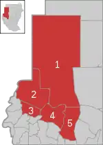
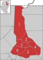
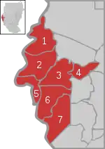
Al Qadarif
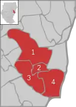
Districts of Al Qadarif
- Al Faw District
- Al Gadaref District
- Al Rahd District
- East Galabat District
- West Galabat District
- Al Fushqa District
- Butana District
- Qala al-Nahl District
- Al-Quresha District[5]
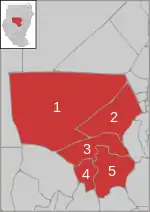
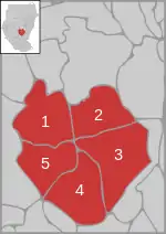
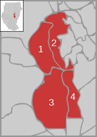
Blue Nile
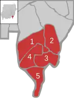
Districts of Blue Nile
- Ad Damazin District
- Al Roseires District
- Geissan District
- Baw District
- Al Kurumik District
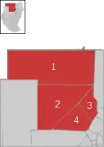
Kassala
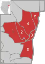
Districts of Kassala
- Seteet District
- Nahr Atbara District
- Kassala District
- Al Gash District
- Hamashkorieb District
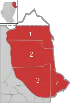
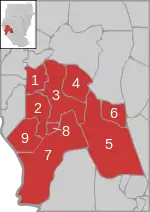
Khartoum
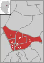
Districts of Khartoum
- Khartoum District
- Um Badda District
- Omdurman District
- Karary District
- Khartoum Bahri District
- Sharg En Nile District
- South Khartoum District
North Darfur
(Not representing the present state structure)
Districts of North Darfur
- Mellit District
- Kutum District
- Kabkabiya District
- Al Fasher District
- Um Kadada District
North Kurdufan
Districts of North Kurdufan
- Sowdari District
- Jebrat al Sheikh District
- Sheikan District
- Bara District
- Um Rawaba District
- En Nuhud District
- Ghebeish District
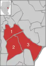
Northern
Districts of Northern Sudan
- Wadi Halfa District
- Dongola District
- Merawi District
- Addabah District
River Nile
Districts of River Nile
- Abu Hamad District
- Berber District
- Ad Damer District
- Atbara District
- Shendi District
- Al Matammah District
South Darfur
(Not reflecting the present state structure)
Districts of South Darfur
- Kas District
- Edd al Fursan District
- Nyala District
- Shearia District
- Al Deain District
- Adayala District
- Buram District
- Tulus District
- Rehed al Birdi District
South Kurdufan
Districts of South Kurdufan
- Dilling District
- Rashad District
- Abu Jubaiyah District
- Talodi District
- Kadugli District
- Lagawa District
- As Salam District
- Abyei District
West Darfur
(Not representing the present state structure)
Districts of West Darfur
- Kulbus District
- Al Geneina District
- Zallingi District
- Jebel Marra District
- Habillah District
- Wadi Salih District
- Mukjar District
White Nile
Districts of White Nile
- Ad Douiem District
- Al Gutaina District
- Kosti District
- Al Jabalian District
See also
- States of Sudan
- Districts of the Southern Sudan
References
- "text of the 2005 constitution in English" (PDF). Archived from the original (PDF) on 2007-06-14. (492 KiB)
- The Interim Constitution of Southern Sudan (PDF) (cushcommunity.org)
- "Sudan Administration Boundaries February 2006" (PDF). World Health Organization. Retrieved 16 July 2021.
- "Sudan - Subnational Administrative Boundaries". Humanitarian Data Exchange. 2020. Retrieved 16 July 2021.
- "الهيكل الإداري" [The Administrative Structure] (in Arabic). Gadarif State. 18 October 2010. Archived from the original on 2013-08-21. Retrieved 16 July 2021.
External links
Wikimedia Commons has media related to maps of districts in Sudan.
This article is issued from Wikipedia. The text is licensed under Creative Commons - Attribution - Sharealike. Additional terms may apply for the media files.