Champfromier
Champfromier (French pronunciation: [ʃɑ̃fʁɔmje]) is a commune in the Ain department in eastern France.[3]
Champfromier | |
|---|---|
Commune | |
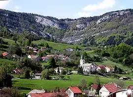 | |
Location of Champfromier | |
 Champfromier  Champfromier | |
| Coordinates: 46°12′00″N 5°49′00″E | |
| Country | France |
| Region | Auvergne-Rhône-Alpes |
| Department | Ain |
| Arrondissement | Nantua |
| Canton | Valserhône |
| Intercommunality | Pays Bellegardien |
| Government | |
| • Mayor (2020–2026) | Jacques Vialon[1] |
| Area 1 | 32.40 km2 (12.51 sq mi) |
| Population (2021)[2] | 718 |
| • Density | 22/km2 (57/sq mi) |
| Time zone | UTC+01:00 (CET) |
| • Summer (DST) | UTC+02:00 (CEST) |
| INSEE/Postal code | 01081 /01410 |
| Elevation | 480–1,540 m (1,570–5,050 ft) (avg. 646 m or 2,119 ft) |
| 1 French Land Register data, which excludes lakes, ponds, glaciers > 1 km2 (0.386 sq mi or 247 acres) and river estuaries. | |
Population
| Year | Pop. | ±% p.a. |
|---|---|---|
| 1968 | 428 | — |
| 1975 | 326 | −3.81% |
| 1982 | 332 | +0.26% |
| 1990 | 440 | +3.58% |
| 1999 | 593 | +3.37% |
| 2007 | 630 | +0.76% |
| 2012 | 696 | +2.01% |
| 2017 | 729 | +0.93% |
| Source: INSEE[4] | ||
See also
References
- "Répertoire national des élus: les maires". data.gouv.fr, Plateforme ouverte des données publiques françaises (in French). 9 August 2021. Archived from the original on 28 March 2023. Retrieved 3 May 2024.
- "Populations légales 2021". The National Institute of Statistics and Economic Studies. 28 December 2023.
- (Ain), Champfromier 2000 (2001). Champfromier: les moissons de la mémoire (in French). Musnier Gilbert (Editions). ISBN 9782910267414.
{{cite book}}: CS1 maint: numeric names: authors list (link) - Population en historique depuis 1968 Archived 26 July 2022 at the Wayback Machine, INSEE
Wikimedia Commons has media related to Champfromier.
This article is issued from Wikipedia. The text is licensed under Creative Commons - Attribution - Sharealike. Additional terms may apply for the media files.