Sandrans
Sandrans (French pronunciation: [sɑ̃dʁɑ̃] ⓘ; Arpitan: Sandrens) is a commune in the Ain department in eastern France.
Sandrans | |
|---|---|
Commune | |
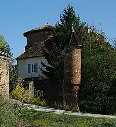 Chateau | |
.svg.png.webp) Coat of arms | |
Location of Sandrans | |
 Sandrans  Sandrans | |
| Coordinates: 46°04′00″N 4°59′00″E | |
| Country | France |
| Region | Auvergne-Rhône-Alpes |
| Department | Ain |
| Arrondissement | Bourg-en-Bresse |
| Canton | Châtillon-sur-Chalaronne |
| Intercommunality | Dombes |
| Government | |
| • Mayor (2020–2026) | Bernard Taponat[1] |
| Area 1 | 29.03 km2 (11.21 sq mi) |
| Population (2021)[2] | 567 |
| • Density | 20/km2 (51/sq mi) |
| Time zone | UTC+01:00 (CET) |
| • Summer (DST) | UTC+02:00 (CEST) |
| INSEE/Postal code | 01393 /01100 |
| Elevation | 235–291 m (771–955 ft) (avg. 280 m or 920 ft) |
| 1 French Land Register data, which excludes lakes, ponds, glaciers > 1 km2 (0.386 sq mi or 247 acres) and river estuaries. | |
Geography
The Chalaronne forms parts of the commune's northeastern border.[3]
Population
| Year | Pop. | ±% p.a. |
|---|---|---|
| 1968 | 361 | — |
| 1975 | 366 | +0.20% |
| 1982 | 379 | +0.50% |
| 1990 | 346 | −1.13% |
| 1999 | 416 | +2.07% |
| 2009 | 527 | +2.39% |
| 2014 | 514 | −0.50% |
| 2020 | 555 | +1.29% |
| Source: INSEE[4] | ||
See also
References
- "Répertoire national des élus: les maires" (in French). data.gouv.fr, Plateforme ouverte des données publiques françaises. 13 September 2022. Archived from the original on 28 June 2020. Retrieved 7 May 2024.
- "Populations légales 2021". The National Institute of Statistics and Economic Studies. 28 December 2023.
- "Map of Sandrans - Michelin Sandrans map". ViaMichelin. Archived from the original on 17 January 2019. Retrieved 17 January 2019.
- Population en historique depuis 1968 Archived 12 December 2023 at the Wayback Machine, INSEE
Wikimedia Commons has media related to Sandrans.
This article is issued from Wikipedia. The text is licensed under Creative Commons - Attribution - Sharealike. Additional terms may apply for the media files.