Kerling-lès-Sierck
Kerling-lès-Sierck (Lorraine Franconian: Kiirléngen/Kerléngen; German: Kerlingen) is a commune in the Moselle department in Grand Est in north-eastern France.
Kerling-lès-Sierck | |
|---|---|
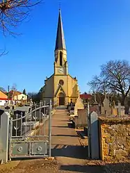 The church in Kerling-lès-Sierck | |
.svg.png.webp) Coat of arms | |
Location of Kerling-lès-Sierck | |
 Kerling-lès-Sierck 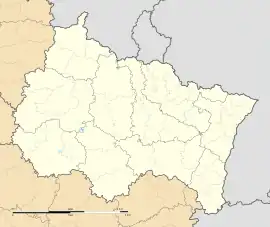 Kerling-lès-Sierck | |
| Coordinates: 49°23′55″N 6°21′01″E | |
| Country | France |
| Region | Grand Est |
| Department | Moselle |
| Arrondissement | Thionville |
| Canton | Bouzonville |
| Intercommunality | Bouzonvillois-Trois Frontières |
| Government | |
| • Mayor (2020–2026) | Guy Hochard[1] |
| Area 1 | 17.82 km2 (6.88 sq mi) |
| Population (2021)[2] | 616 |
| • Density | 35/km2 (90/sq mi) |
| Time zone | UTC+01:00 (CET) |
| • Summer (DST) | UTC+02:00 (CEST) |
| INSEE/Postal code | 57361 /57480 |
| Elevation | 175–311 m (574–1,020 ft) (avg. 380 m or 1,250 ft) |
| 1 French Land Register data, which excludes lakes, ponds, glaciers > 1 km2 (0.386 sq mi or 247 acres) and river estuaries. | |
See also
References
- "Répertoire national des élus: les maires". data.gouv.fr, Plateforme ouverte des données publiques françaises (in French). 2 December 2020.
- "Populations légales 2021". The National Institute of Statistics and Economic Studies. 28 December 2023.
External links
 Media related to Kerling-lès-Sierck at Wikimedia Commons
This article is issued from Wikipedia. The text is licensed under Creative Commons - Attribution - Sharealike. Additional terms may apply for the media files.